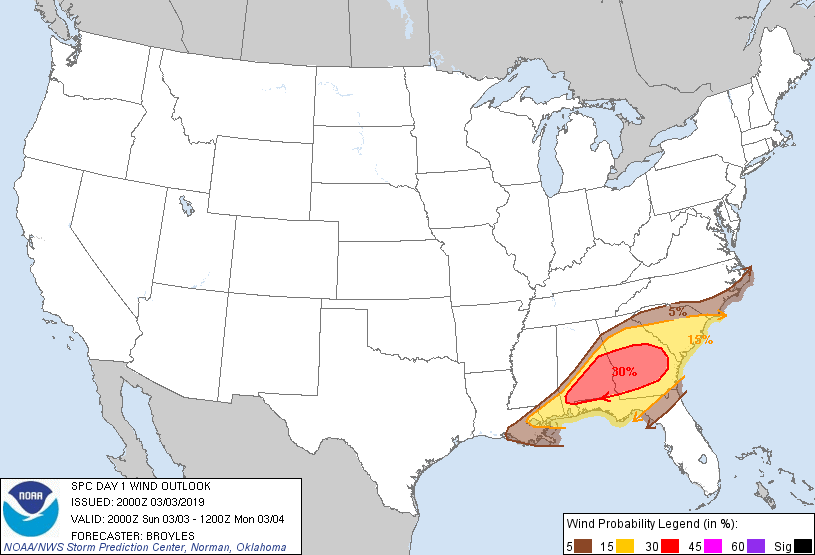
New Orleans, LA...Tallahassee, FL...Wilmington, NC...Jacksonville, NC...Marrero, LA...
Probabilistic Damaging Wind Graphic
Probability of damaging thunderstorm winds or wind gusts of 50 knots or higher within 25 miles of a point. Hatched Area: 10% of greater probability of wind gusts 65 knots or greater within 25 miles of a point.
New Orleans, LA...Gainesville, FL...Wilmington, NC...Kenner, LA...Jacksonville, NC...
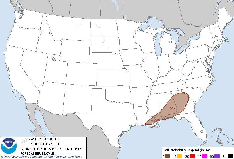
Probabilistic Large Hail Graphic
Probability of hail 1" or larger within 25 miles of a point. Hatched Area: 10% or greater probability of hail 2" or larger within 25 miles of a point.
Day 1 Hail Risk
Area (sq. mi.)
Area Pop.
Some Larger Population Centers in Risk Area
5 %
84,558
12,925,785
New Orleans, LA...Atlanta, GA...Montgomery, AL...Mobile, AL...Columbus, GA...
SPC AC 032000
Day 1 Convective Outlook
NWS Storm Prediction Center Norman OK
0200 PM CST Sun Mar 03 2019
Valid 032000Z - 041200Z
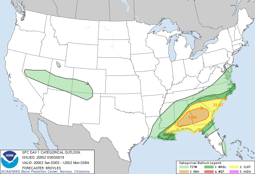
...THERE IS AN ENHANCED RISK OF SEVERE THUNDERSTORMS ACROSS PARTS OF
SOUTHERN ALABAMA...THE FAR WESTERN FLORIDA PANHANDLE...SOUTHWEST AND
SOUTH-CENTRAL GEORGIA...
...SUMMARY...
Severe thunderstorms with tornadoes and damaging gusts are expected
over parts of the Southeast this afternoon into early evening.
...DISCUSSION...
A few changes have been made to the outlook for this issuance. The
first change is to expand the enhanced area a bit further east along
the expected path of a squall-line producing wind damage that is
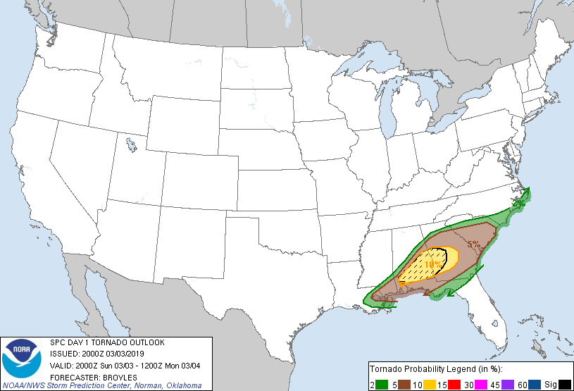
currently located in south-central Alabama. The 10 percent tornado
contour has also been expanded slightly eastward across
south-central Georgia where supercells with a tornado threat are
expected to track this afternoon. The third change is to trim the
slight and marginal risk areas from parts of south-central
Mississippi and west-central Alabama behind a cold front moving
southeast. The fourth change is to remove thunder from parts of the
East Texas and the Arklatex where thunderstorm development is not
expected due to the drying airmass.
..Broyles.. 03/03/2019
.PREV DISCUSSION... /ISSUED 0951 AM CST Sun Mar 03 2019/
...MS/AL/GA/FL into the Carolinas...
A strong and progressive shortwave trough is moving quickly eastward
across the central US today. Ahead of the trough, strong
southwesterly low-level winds and low-level cyclogenesis will help
to transport rich gulf moisture northward into parts of the
southeast states. The result will be a line of intense
thunderstorms tracking from MS across AL/GA/FL Panhandle today, and
into the Carolinas tonight.
Storms are strengthening this morning over southern MS along the
primary cold front. This activity will likely develop into a severe
squall line by early afternoon and spread eastward across the ENH
risk area of southern AL and southern/central GA. Damaging winds
will be the main threat with this line, although a few transient
QLCS tornado circulations are also expected.
Forecast soundings and visible satellite imagery suggest that the
air mass ahead of the line will slowly destabilize through the
afternoon, with little cap noted. This will promote the risk of a
few discrete storms and a more appreciable threat of tornadoes ahead
of the primary squall line. Strong low-level shear and sufficient
CAPE indicate a risk of intense supercells with a strong tornado or
two possible. This scenario will exist ahead of the line throughout
the ENH risk area.
Farther east and later this evening, the squall line is likely to
maintain sufficient intensity to continue to pose a risk for
damaging winds and isolated tornadoes across much of eastern GA and
SC.
CLICK TO GET WUUS01 PTSDY1 PRODUCT
NOTE: THE NEXT DAY 1 OUTLOOK IS SCHEDULED BY 0100Z