San Antonio, TX...Oklahoma City, OK...St. Louis, MO...Madison, WI...Shreveport, LA...
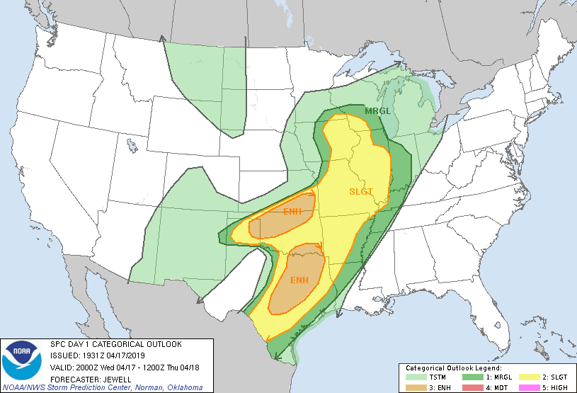
MARGINAL
165,140
28,573,760
Chicago, IL...Houston, TX...Indianapolis, IN...Memphis, TN...Kansas City, MO...
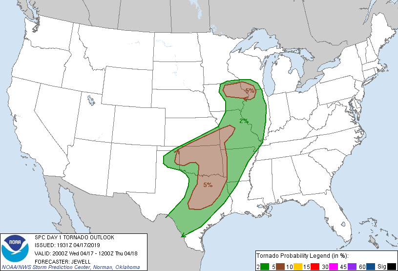
Probabilistic Tornado Graphic
Probability of a tornado within 25 miles of a point. Hatched Area: 10% or greater probability of EF2 - EF5 tornadoes within 25 miles of a point.
Day 1 Tornado Risk
Area (sq. mi.)
Area Pop.
Some Larger Population Centers in Risk Area
5 %
162,377
16,704,744
Dallas, TX...Fort Worth, TX...Oklahoma City, OK...Tulsa, OK...Arlington, TX...
2 %
253,761
21,129,779
San Antonio, TX...Austin, TX...Kansas City, MO...St. Louis, MO...Madison, WI...
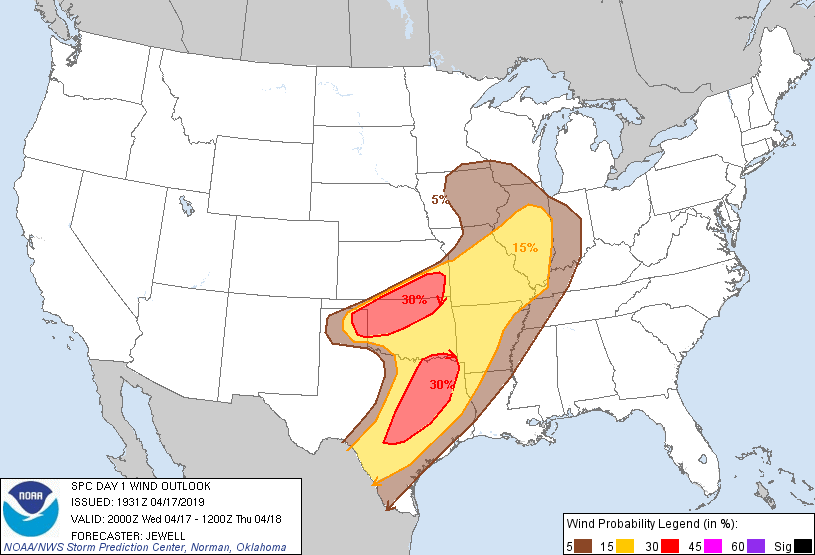
Probabilistic Damaging Wind Graphic
Probability of damaging thunderstorm winds or wind gusts of 50 knots or higher within 25 miles of a point. Hatched Area: 10% of greater probability of wind gusts 65 knots or greater within 25 miles of a point.
San Antonio, TX...Oklahoma City, OK...Tulsa, OK...St. Louis, MO...Madison, WI...
5 %
193,066
30,429,193
Chicago, IL...Houston, TX...Indianapolis, IN...Memphis, TN...Kansas City, MO...
   SPC AC 171931

   Day 1 Convective Outlook
   NWS Storm Prediction Center Norman OK
   0231 PM CDT Wed Apr 17 2019

   Valid 172000Z - 181200Z

   ...THERE IS AN ENHANCED RISK OF SEVERE THUNDERSTORMS ACROSS MUCH OF
   CENTRAL AND NORTHERN TX INTO SOUTHEAST OK...AND ACROSS MUCH OF
   NORTHERN OK INTO SOUTHEAST KS...

   ...SUMMARY...
   Scattered to numerous severe storms are expected from the Texas
   Panhandle to the Mid-Mississippi Valley from late afternoon through
   tonight, and from south-central to northeast Texas, mainly this
   evening into tonight. Very large hail, damaging winds, and a few
   tornadoes are possible.

   No change was made to the previous outlook as the bulk of the severe
   activity is expected later this afternoon and evening across TX, KS
   and MO.

   ...TX Panhandle into western/northwest OK...
   A single storm producing large hail was noted over Donley county TX
   at 1930Z, and this general zone along the cold front into northwest
   OK will continue to destabilize and become more favorable for
   additional storm development, with damaging hail and wind the most
   likely threats.

   ..Jewell.. 04/17/2019

   .PREV DISCUSSION... /ISSUED 1128 AM CDT Wed Apr 17 2019/

   ...TX Panhandle to the Mid-MS Valley...
   Highest confidence signal for severe storm development is across
   this region. Thunderstorms will form in the vicinity of the surface
   cyclone over the TX Panhandle by 21Z and then develop northeast
   along a quasi-stationary front across northwest OK to southeast KS
   through the early evening. Very steep mid-level lapse rates of 8-9
   C/km will support a warm sector characterized by MLCAPE of 1000-2500
   J/kg. Storms initially will pose a threat for very large hail and a
   couple tornadoes. However, upscale growth/consolidation is expected
   rather quickly given the degree of ascent and orientation of the
   deep-layer wind fields to the front. Latest CAMs are somewhat
   inconsistent with the degree of development into the higher-quality
   buoyancy across central OK.

   40-50 kt effective shear will support potential for several bowing
   line segments as the cold front sharpens during the evening.
   Damaging winds, some embedded hail, and a few tornadoes will be
   possible as multiple MCSs likely persist east-northeast towards the
   Mid-MS Valley overnight.

   ...South-central TX to southeast OK/western AR...
   Will generally maintain previous forecast with little change evident
   for this outlook. Low confidence exists in warm-sector development
   this afternoon. ARW-based CAMs are aggressive with this occurring in
   the northeast TX vicinity which may support an all hazards risk
   during the late afternoon and early evening. However, ongoing
   widespread stratus beneath a stout EML suggests that a capping
   inversion may hold. In addition, a subtle mid-level impulse
   traversing the region soon should result in veer-back-veer low to
   mid-level wind profiles which may temper overall supercell
   structure/intensity should development occur.

   A more likely scenario is convective development between 00-03Z
   across central TX as convergence strengthens along the composite
   dryline/Pacific cold front. Initially, large hail should be the
   primary hazard, but upscale growth into an extensive MCS is likely.
   Around 50-kt effective shear should support embedded bowing
   structures with severe wind gusts, some hail, and brief tornado
   threat continuing east-northeast overnight towards the Ark-La-Tex/TX
   Coastal Plain.

   ...Eastern IA/Southern WI/Northwest IL...
   The severe threat here is highly conditional as warm-sector
   boundary-layer moisture per 12Z soundings may be inadequate to
   support substantial warm-sector convective development beneath the
   northern periphery of the EML. Latest CAMs suggest minimal, if any,
   development occurring amid weak large-scale ascent in the warm
   sector. Nevertheless, low-level wind profiles will be supportive of
   updraft rotation as slightly backed surface winds should persist to
   the southeast of a cyclone near the MN/IA border area in late
   afternoon. Should a few storms become sustained, all hazards are
   possible but the tornado/hail threat should be dominant.

   CLICK TO GET WUUS01 PTSDY1 PRODUCT

   NOTE: THE NEXT DAY 1 OUTLOOK IS SCHEDULED BY 0100Z