Indianapolis, IN...Kansas City, MO...Amarillo, TX...Overland Park, KS...Waco, TX...
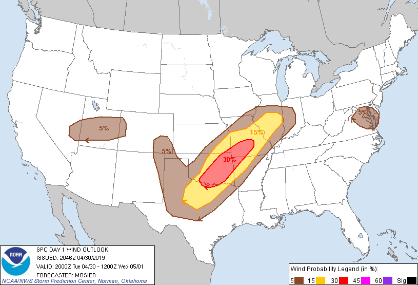
Probabilistic Damaging Wind Graphic
Probability of damaging thunderstorm winds or wind gusts of 50 knots or higher within 25 miles of a point. Hatched Area: 10% of greater probability of wind gusts 65 knots or greater within 25 miles of a point.
Day 1 Wind Risk
Area (sq. mi.)
Area Pop.
Some Larger Population Centers in Risk Area
30 %
54,307
4,526,620
Oklahoma City, OK...Tulsa, OK...Springfield, MO...Norman, OK...Wichita Falls, TX...
Baltimore, MD...Washington, DC...Kansas City, MO...Lubbock, TX...Richmond, VA...
SPC AC 302046
Day 1 Convective Outlook AMEND 1
NWS Storm Prediction Center Norman OK
0346 PM CDT Tue Apr 30 2019
Valid 302000Z - 011200Z
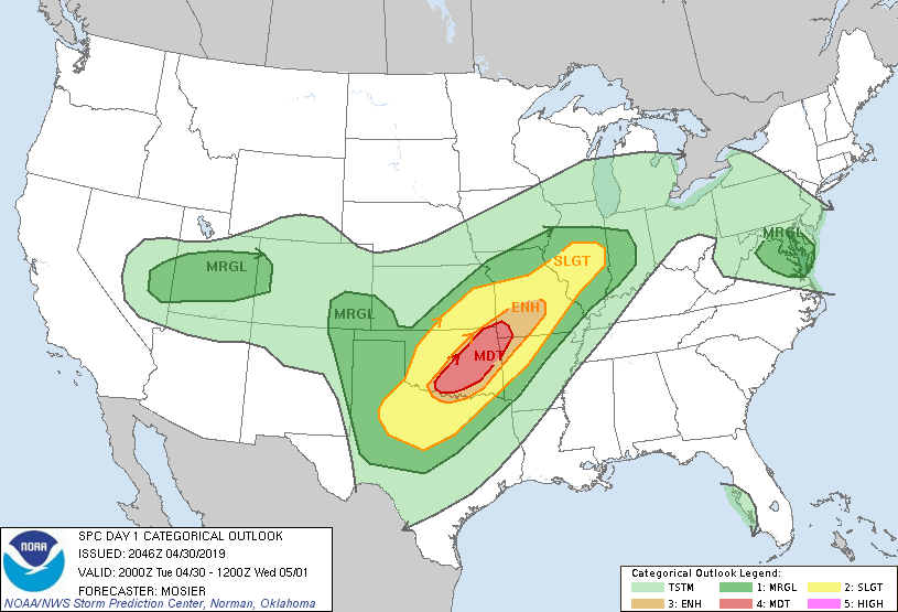
...THERE IS A MODERATE RISK OF SEVERE THUNDERSTORMS ACROSS CENTRAL
AND EASTERN OK...FAR SOUTHWEST MO...AND FAR NORTHWEST AR...
AMENDED TO UPGRADE TO MODERATE RISK
...SUMMARY...
Severe thunderstorms are possible in a corridor across parts of the
southern Plains northeastward toward Illinois/Indiana today and
tonight. This will include a risk for tornadoes, large hail, and
locally damaging gusts.
...Amendment Discussion...
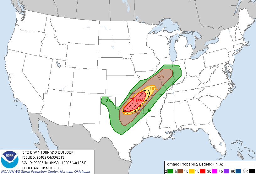
An upgrade to Moderate is being issued based on recent data from 20Z
OUN sounding and a recent special NSSL sounding in southwest OK.
These soundings show an uncapped environment with strong low-level
hodographs (lengthened by 40 to 50 kt within the 850 mb layer).
Resulting 0-1 km SRH values are around 300 m2/s2. This environment
downstream of developing storms in SW OK and Far NW TX as well as
the expected increase in the low-level jet later increases
confidence in higher tornado probabilities.
Numerous tornadic supercells across northwest OK, southwest MO, and
northwest AR also warrant the upgrade.
...Previous 20Z Update Discussion...
...TX/OK...
Recent surface analysis places a boundary from low over southeast KS
southwestward across central OK to near FDR in southwest OK. The
boundary then extends more south-southwestward towards SANK and then
westward through the Permian Basin. Portion of this boundary over
central and southwest OK is moving gradually northward as a warm
front. CHK has gone from 67/64 at 18Z to 77/70 at 19Z with a
southeast wind gusting to 25 kt. In relation to this shift in the
frontal position, severe probabilities where increased west of a
line from TIK to DUC.
18Z sounding at FWD showed a deep moist layer beneath a
well-developed elevated mixed layer. Resultant capping is expected
to weaken over the next few hours as the shortwave trough over the
southern High Plains continues eastward. As it does, convective
coverage will likely increase across western north TX and southwest
OK. The beginnings of this scenario appears to be underway with
developing storms near the boundary from CHK southwestward into far
northwest TX.
Severe probabilities were also increased across portions of the TX
South Plains and east-central NM. In this area, cumulus has been
building along a well-defined surface boundary and the potential for
convective initiation has increased. More details about this region
are available in MCD 481.
...MO/IL...
Thunderstorm coverage is expected to continue increasing near and
south of the front extending from the central IL/IN border
southwestward into northeast OK. Environment remains supportive of
severe thunderstorms, particularly if cells continue to remain
discrete.
..Mosier/Hart.. 04/30/2019
.PREV DISCUSSION... /ISSUED 1105 AM CDT Tue Apr 30 2019/
...TX/OK/MO/AR...
Water vapor imagery shows a strong upper trough moving across
eastern NM this morning, with fast southwesterly flow aloft across
all of the southern Plains. Ample moisture and instability is
present over TX/OK/AR with dewpoints in the 60s to lower 70s and
near dry-adiabatic mid level lapse rates. A surface boundary
extends from southeast KS into central OK and northwest TX. This
boundary is expected to remain nearly stationary through the day, as
the warm sector slowly warms into the mid/upper 70s. The result
will be a rather widespread area of substantial CAPE (MLCAPE over
3000 J/kg) and minimal inhibition from southwest MO into southern OK
and north TX.
Meanwhile, model guidance is consistent in developing a strong
southerly low-level jet over north TX and southeast OK by late
afternoon. This will enhance the low-level shear profiles (SRH
values of 200-350 ms/s2) and encourage supercell storm structures.
Given the relatively weak cap, 12z CAM solutions suggest numerous
rotating storms will occur this afternoon and evening over the ENH
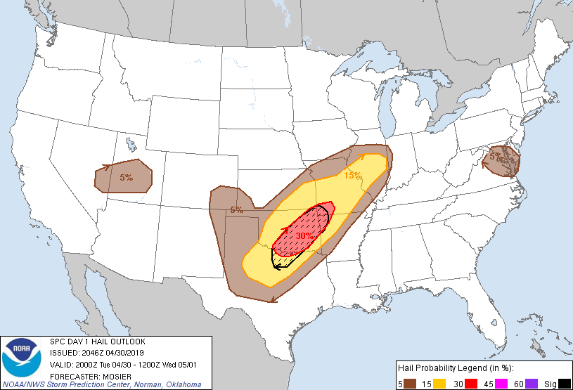
risk area. These storms would pose a risk of tornadoes, large hail,
and damaging winds. If model solution are right in the widespread
nature of storm development, destructive interference between storms
may limit the potential of a more significant severe/tornado event.
Nevertheless, a strong tornado or two is possible today - mainly
across south-central into eastern OK.
It is also uncertain how far south storms will form into TX. Only a
few 12z CAMs show storms developing south of the DFW area, but
forecast soundings suggest a conditional risk of hail and damaging
winds with any storms that form in this area. Therefore have nudged
the severe risk areas slightly farther south.
Later this evening and tonight, lines and clusters of storms will
develop eastward into parts of southern MO and western AR, with a
continued risk of damaging winds and a few tornadoes.
...NV/UT...
Behind the primary upper trough over NM, a second progressive system
is moving across northern CA and will dig into the Great Basin
today. Scattered thunderstorms are expected to form this afternoon
over east-central NV and spread into UT. The strongest of these
cells will pose a risk of gusty winds and hail.
CLICK TO GET WUUS01 PTSDY1 PRODUCT
NOTE: THE NEXT DAY 1 OUTLOOK IS SCHEDULED BY 0100Z