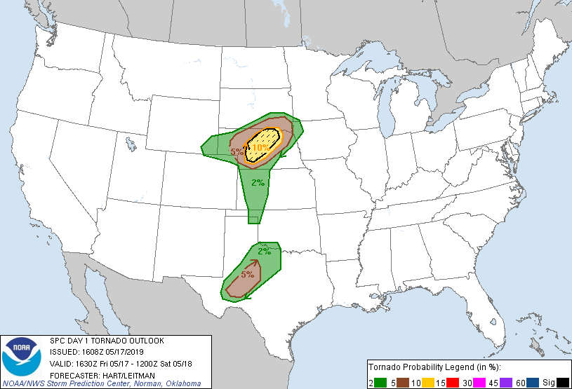
Probability of a tornado within 25 miles of a point. Hatched Area: 10% or greater probability of EF2 - EF5 tornadoes within 25 miles of a point.
Day 1 Tornado Risk
Area (sq. mi.)
Area Pop.
Some Larger Population Centers in Risk Area
SIG SEVERE
17,201
90,559
North Platte, NE...
10 %
24,215
138,875
North Platte, NE...Lexington, NE...
5 %
48,839
608,161
San Angelo, TX...Kearney, NE...Big Spring, TX...Norfolk, NE...Mitchell, SD...
2 %
103,177
1,847,398
Sioux Falls, SD...Abilene, TX...Wichita Falls, TX...Midland, TX...Odessa, TX...
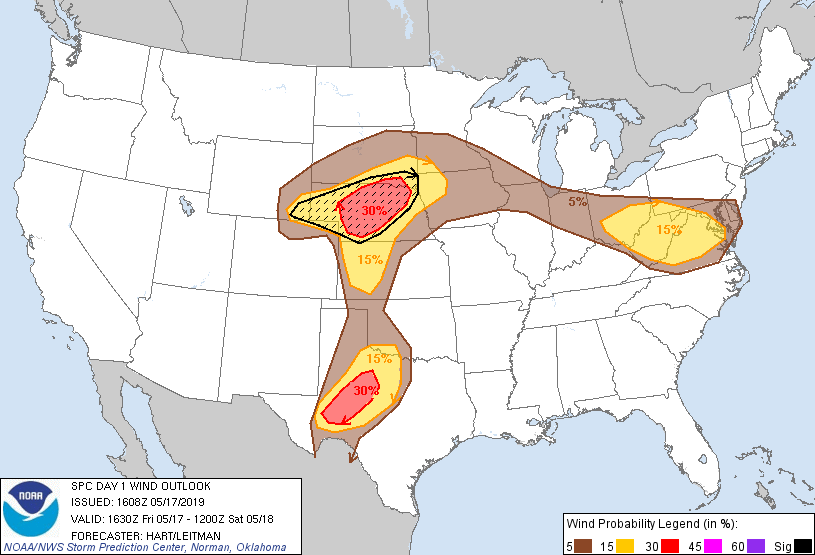
Probabilistic Damaging Wind Graphic
Probability of damaging thunderstorm winds or wind gusts of 50 knots or higher within 25 miles of a point. Hatched Area: 10% of greater probability of wind gusts 65 knots or greater within 25 miles of a point.
SPC AC 171608
Day 1 Convective Outlook
NWS Storm Prediction Center Norman OK
1108 AM CDT Fri May 17 2019
Valid 171630Z - 181200Z
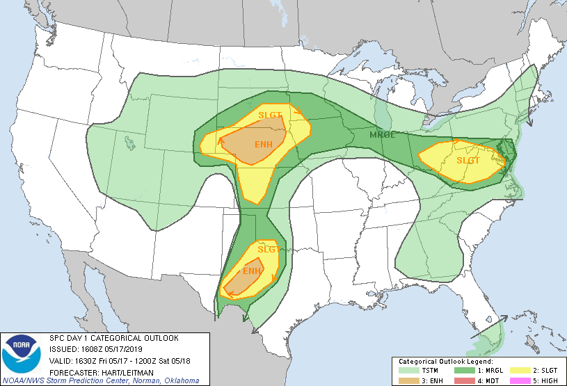
...THERE IS AN ENHANCED RISK OF SEVERE THUNDERSTORMS OVER PARTS OF
NEBRASKA AND SOUTHEAST SOUTH DAKOTA...
...THERE IS A SLIGHT RISK OF SEVERE THUNDERSTORMS OVER PARTS OF THE
HIGH PLAINS...AND OVER THE MID-ATLANTIC REGION...
...SUMMARY...
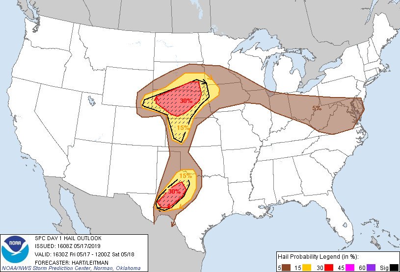
Severe storms with very large hail, damaging winds, and a few
tornadoes (a couple of which could be strong) are expected over
Nebraska and adjacent regions this afternoon and evening. A few
severe storms capable of very large hail and damaging winds will
also affect portions of western Texas. Finally, scattered afternoon
storms capable of locally gusty/damaging winds will be possible from
Ohio through the Middle Atlantic region.
...NE and vicinity...
Morning water vapor loop shows a powerful upper trough digging
across the Great Basin into the Rockies. Midlevel height falls and
wind speeds are increasing over the High Plains, where multiple
clusters of severe thunderstorms are forecast for this afternoon and
tonight. One area of concern will be over parts of eastern CO/WY,
northern KS, much of NE, and southern SD. Storms are expected to
initiate by late afternoon over northeast CO into southwest NE and
northwest KS, with forecast hodographs favoring supercell storm
modes. Steep midlevel lapse rates and ample CAPE will encourage
hail production, with very large hail possible. The corridor of
greatest tornado threat is forecast to extend across central and
northern NE as storms track north-northeastward across a moist and
moderately unstable warm sector. Intense storms should eventually
move into parts of SD where they may become elevated, but remain
capable of large hail.
...Southwest TX...
A very moist and unstable air mass is in place today over parts of
southwest TX, with dewpoints in the upper 60s extending from Del Rio
to Abilene, TX. A few intense storms are expected to form in this
region this afternoon, but should remain rather isolated. These
storms will pose a risk of very large hail and perhaps a tornado.
More widespread convection will develop after dark across the
SLGT/ENH risk area. These storms will maintain organization through
the overnight period and spread toward northwest TX and southwest
OK, posing a risk of large hail and damaging winds.
...Mid Atlantic States...
Pockets of strong heating and sufficient CAPE will lead to scattered
thunderstorm development over parts of OH/WV this afternoon.
Moderately strong west-northwest flow aloft will help to organize
these storms and spread them toward parts of VA. Confidence in an
organized severe threat in this area is not particularly high, but
there is a risk of gusty/damaging winds in the strongest cells this
afternoon and evening.
..Hart/Leitman.. 05/17/2019
CLICK TO GET WUUS01 PTSDY1 PRODUCT
NOTE: THE NEXT DAY 1 OUTLOOK IS SCHEDULED BY 2000Z