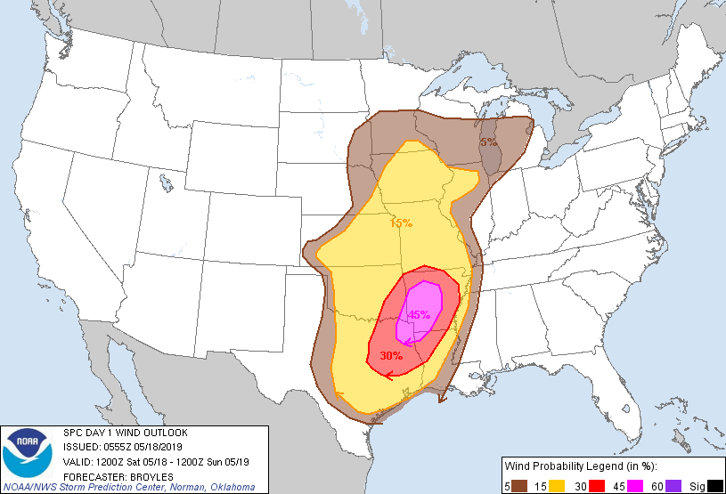
Probability of damaging thunderstorm winds or wind gusts of 50 knots or higher within 25 miles of a point. Hatched Area: 10% of greater probability of wind gusts 65 knots or greater within 25 miles of a point.
Day 1 Wind Risk
Area (sq. mi.)
Area Pop.
Some Larger Population Centers in Risk Area
45 %
31,654
1,927,462
Shreveport, LA...Little Rock, AR...Longview, TX...Bossier City, LA...North Little Rock, AR...
SPC AC 180555
Day 1 Convective Outlook
NWS Storm Prediction Center Norman OK
1255 AM CDT Sat May 18 2019
Valid 181200Z - 191200Z
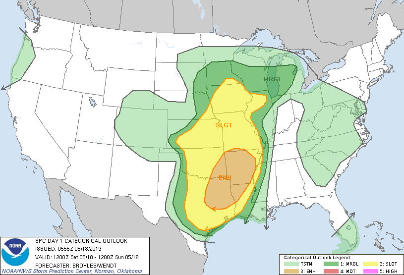
...THERE IS AN ENHANCED RISK OF SEVERE THUNDERSTORMS ACROSS PARTS OF
SOUTHEAST OKLAHOMA...EAST TEXAS...ARKANSAS...FAR SOUTHERN MISSOURI
AND NORTHWEST LOUISIANA...
...SUMMARY...
Severe storms are possible over a large area today, from Texas to
southern Minnesota, with the greatest threat from northeast Texas
across southeast Oklahoma into Arkansas and northwest Louisiana. A
few tornadoes, widespread damaging winds and large hail are
expected.
...Significant Event Including Widespread Wind Damage and a Few
Strong Tornadoes Expected Today across parts of the Southern Plains,
Arklatex and southern Ozarks...
...Southern Plains/Arklatex/Southern Ozarks...
A negatively-tilted upper-level trough will move eastward into the
southern High Plains today as a moist and unstable airmass advects
northward into the southern Plains. A cluster of strong to severe
thunderstorms is expected to be ongoing across north-central Texas
and southwest Oklahoma during the morning, associated with a 40 to
50 kt low-level jet. Model forecasts develop this cluster upscale
into an MCS, moving a squall-line eastward across Oklahoma and north
Texas during the day. As surface heating takes place ahead of the
line, cell intensity within the cluster is expected to gradually
increase. Surface dewpoints ahead of the MCS should be in the upper
60s and lower 70s F with MLCAPE values reaching the 2500 to 3500
J/Kg range by early afternoon. In addition, a 60 to 70 kt mid-level
jet is forecast to move across the southern Plains. This feature
will enhance lift and create strong deep-layer shear profiles
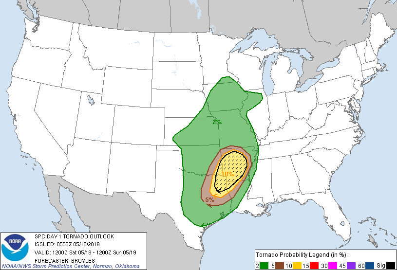
favorable for bow echoes within the squall-line. An isolated tornado
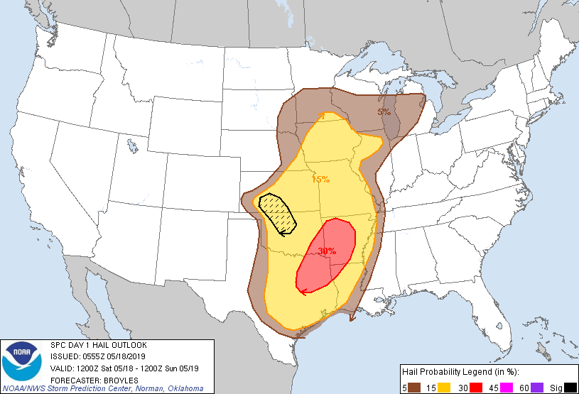
threat along with potential for wind damage and isolated large hail
is forecast during the early afternoon across parts of eastern
Oklahoma and northeast Texas.
As the linear MCS moves into far eastern Oklahoma, western Arkansas
and far northeast Texas, the current thinking is that new convection
will develop on the southern end of the MCS. At the same time, the
strengthening low-level jet will become coupled with the mid-level
jet. In addition, a cluster of discrete cells could also develop
ahead of the squall-line across western Arkansas and far northeast
Texas with a shear environment favorable for supercells and
tornadoes. There is conditionality associated with this scenario.
RAP forecast soundings at 21Z in southwest Arkansas show MLCAPE
values of 2000 to 3000 J/kg with 0-6 km shear in the 35 to 45 kt
range. This combined with looped hodographs and 0-3 km storm
relative helicities of 300 to 400 m2/s2 would be favorable for
strong tornadoes if a cluster of discrete cells can develop. The
more certain scenario would be for widespread wind damage to occur
along the leading edge of the linear MCS. The threat is expected to
be maximized across western and central Arkansas extending
southwestward into far northeast Texas in the 20Z to 00Z time-frame.
The severe threat should be less with south south-westward extent
into east Texas where wind damage and large hail will be possible. A
wind damage threat and potential for tornadoes associated with the
squall-line is expected to continue into the evening as far east as
the Mississippi River.
...South-central and Southwest Kansas/Northwest and North-central
Oklahoma...
A negatively-tilted upper-level trough will move into the southern
High Plains today. At the surface, a low is forecast to develop in
the northeastern Texas Panhandle as a cold front advances
southeastward across western Kansas. Surface heating ahead of the
front should enable a corridor of moderate instability to develop
from western Kansas southeastward into northwest Oklahoma by
afternoon. Isolated to scattered thunderstorm initiation is expected
to occur along this corridor during the mid to late afternoon just
ahead of a shortwave trough. RAP forecast soundings from Dodge City
to northwest of Oklahoma City late this afternoon show MLCAPE values
in the 1500 to 2000 J/kg range with 0-6 km shear of 45 to 55 kt.
This combined with steep mid-level lapse rates approaching 8.0 C/km
should be favorable for supercells with large hail. Supercells that
develop where instability becomes strongest, may have potential to
produce hailstones of 2 inches or greater in diameter. A wind damage
threat is also expected but cell coverage may remain somewhat
isolated across the area.
...Lower to Mid Missouri Valley/Mid to Upper Mississippi Valley...
South-southwesterly mid-level flow will be in place today across the
central Plains and lower to mid Missouri Valley. At the surface, a
cold front will advance eastward across the mid Missouri Valley as a
low develops across northwest Iowa. The moist sector should be
located to the southeast of the low across much of Iowa extending
southward into north-central Missouri. Surface heating will likely
enable a pocket of moderate instability to develop across the moist
sector by afternoon. This combined with increasing low-level
convergence to the southeast of the surface low should result in
scattered thunderstorm development during the mid to late afternoon.
RAP forecast soundings at Des Moines late this afternoon show MLCAPE
values of 2000 to 3000 J/kg with 0-6 km shear around 30 kt. This
combined with steep mid-level lapse rates would be enough for
rotating cells or organized multicells capable of producing isolated
large hail. Wind damage would also be possible, especially with fast
moving short line segments. The severe threat could persist into the
early evening mainly in areas where instability is the strongest.
..Broyles/Wendt.. 05/18/2019
CLICK TO GET WUUS01 PTSDY1 PRODUCT
NOTE: THE NEXT DAY 1 OUTLOOK IS SCHEDULED BY 1300Z