Columbia, MO...Broken Arrow, OK...Quincy, IL...Jefferson City, MO...Shawnee, OK...
5 %
49,135
4,543,988
Oklahoma City, OK...Springfield, MO...Springfield, IL...Peoria, IL...Norman, OK...
2 %
92,661
18,829,167
Columbus, OH...Kansas City, MO...Cleveland, OH...Wichita, KS...Cincinnati, OH...
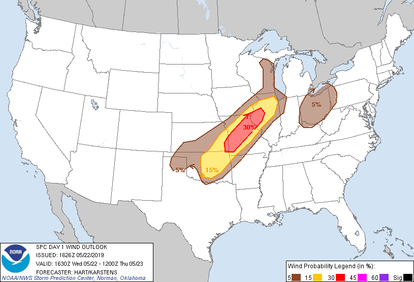
Probabilistic Damaging Wind Graphic
Probability of damaging thunderstorm winds or wind gusts of 50 knots or higher within 25 miles of a point. Hatched Area: 10% of greater probability of wind gusts 65 knots or greater within 25 miles of a point.
Day 1 Wind Risk
Area (sq. mi.)
Area Pop.
Some Larger Population Centers in Risk Area
30 %
36,019
1,696,387
Columbia, MO...Joplin, MO...Quincy, IL...Jefferson City, MO...Pekin, IL...
15 %
83,547
12,938,761
Oklahoma City, OK...Kansas City, MO...Tulsa, OK...Aurora, IL...Overland Park, KS...
SPC AC 221626
Day 1 Convective Outlook
NWS Storm Prediction Center Norman OK
1126 AM CDT Wed May 22 2019
Valid 221630Z - 231200Z
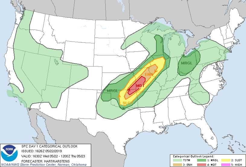
...THERE IS A MODERATE RISK OF SEVERE THUNDERSTORMS THIS AFTERNOON
AND EVENING OVER PARTS OF NORTHEAST OKLAHOMA...SOUTHEAST
KANSAS...AND WESTERN AND CENTRAL MISSOURI...
...SUMMARY...
Severe thunderstorms are forecast this afternoon into evening from
central and northeast Oklahoma into Missouri and central Illinois.
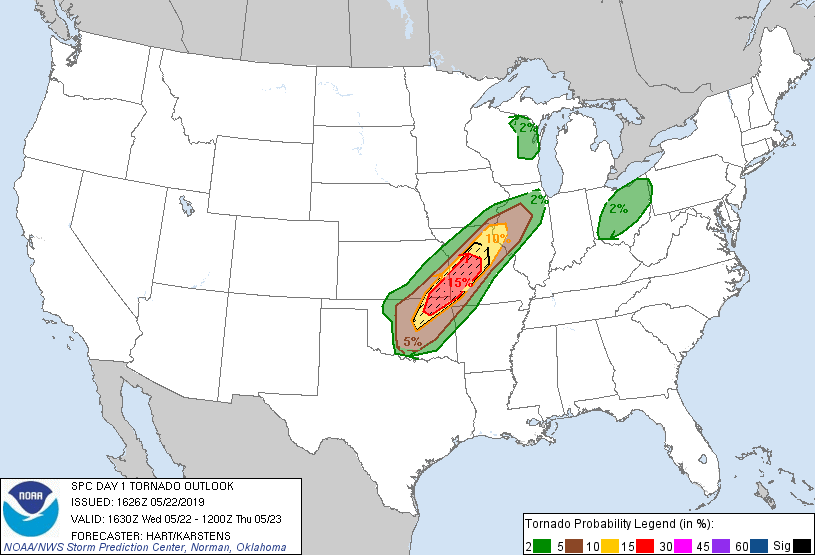
Tornadoes, large/damaging hail and severe gusts all are possible.
...OK to IL...
Given latest model guidance and observational trends, have opted to
upgrade to MDT risk along a narrow corridor from northeast OK into
central MO. Consensus continues to grow in model guidance that
several discrete supercells will develop along this corridor this
afternoon and evening, as low-level moisture streams northward and
shear profiles rapidly strengthen. The primary negative indicator
of a more significant severe weather event involves the large scale
pattern, and the large midlevel height rises that are occurring
throughout the Plains. However, latest water vapor loop and model
guidance suggest very subtle shortwave troughs embedded in the upper
flow, with one currently over southwest OK. This feature would
arrive into the risk area around peak heating, potentially helping
initiation. Forecast soundings suggest an environment favorable for
strong tornadoes and very large hail and if discrete supercells can
form.
It is unclear how far southwest the development will occur into
central OK. Several 12z CAM solutions suggest 1-2 storms near OKC
that could be severe if they develop, with a conditional risk of
significant tornadoes and hail. However, confidence in persistent
thunderstorms that far southwest is lower than farther northeast.
Storms that form over central MO will spread eastward into
central/northern IL during the evening, with the continued risk of
supercells capable of large hail, damaging winds, and a few
tornadoes. It is unclear how rich the low-level moisture will be
ahead of the storms, but shear profiles will be quite favorable in
this area.
..Hart/Karstens.. 05/22/2019
CLICK TO GET WUUS01 PTSDY1 PRODUCT
NOTE: THE NEXT DAY 1 OUTLOOK IS SCHEDULED BY 2000Z