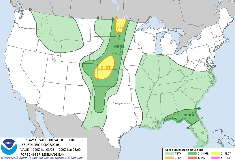
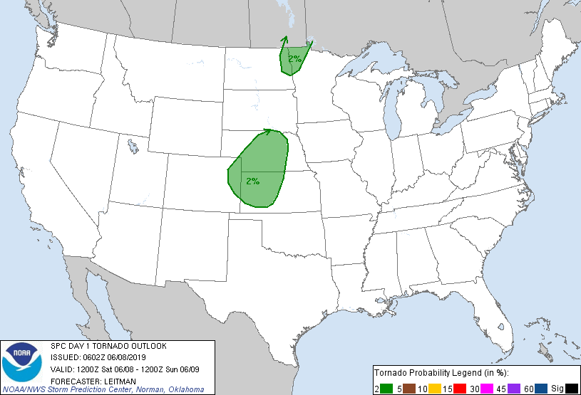
Probability of a tornado within 25 miles of a point. Hatched Area: 10% or greater probability of EF2 - EF5 tornadoes within 25 miles of a point.
Day 1 Tornado Risk
Area (sq. mi.)
Area Pop.
Some Larger Population Centers in Risk Area
2 %
98,277
846,661
Grand Forks, ND...Grand Island, NE...Kearney, NE...Garden City, KS...Dodge City, KS...
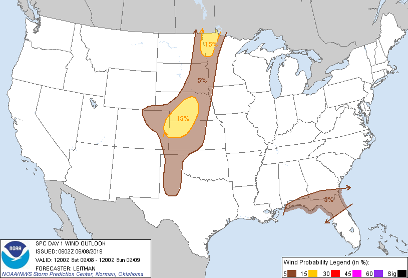
Probabilistic Damaging Wind Graphic
Probability of damaging thunderstorm winds or wind gusts of 50 knots or higher within 25 miles of a point. Hatched Area: 10% of greater probability of wind gusts 65 knots or greater within 25 miles of a point.
Day 1 Wind Risk
Area (sq. mi.)
Area Pop.
Some Larger Population Centers in Risk Area
15 %
65,747
797,347
Fargo, ND...Grand Forks, ND...Grand Island, NE...Moorhead, MN...Kearney, NE...
   SPC AC 080602

   Day 1 Convective Outlook
   NWS Storm Prediction Center Norman OK
   0102 AM CDT Sat Jun 08 2019

   Valid 081200Z - 091200Z

   ...THERE IS A SLIGHT RISK OF SEVERE THUNDERSTORMS ACROSS PORTIONS
   CENTRAL NE INTO NORTHWEST KS AND EAST-CENTRAL CO AS WELL AS PARTS OF
   FAR EASTERN ND AND NORTHWEST MN...

   ...SUMMARY...
   Strong to severe thunderstorms are expected this afternoon and
   evening from eastern North Dakota and northwest Minnesota into the
   central Plains. Damaging wind gusts and large hail will be the main
   threats with these storms. Additional strong storms could produce
   some strong gusts across parts of the Southeast.

   ...Eastern Dakotas into Western Minnesota...

   A potent shortwave trough will shift east from the northern Rockies
   toward the northern and central Plains today. Midlevel southwesterly
   flow of 35-50 kt will overspread eastern ND into western MN by early
   afternoon as a surface cold front advances eastward across the
   Dakotas. Moderate southerly surface to 850 mb flow will maintain low
   to mid 60s dewpoints ahead of the front while temperatures warm into
   the upper 70s to low 80s. This will result in a corridor of
   1000-2000 J/kg MLCAPE ahead of the cold front and vigorous
   thunderstorm development is expected by late morning/early afternoon
   across the eastern Dakotas. There is some potential that storms
   could become undercut by the cold front, given generally
   boundary-parallel deep-layer flow. The best chance for organized,
   potentially forward-propagating cluster appears to be over parts of
   northeast ND into northwest MN where stronger effective shear and
   modest 0-3km SRH will foster better organized structures.  Steep
   low-level lapse rates and 35-45 kt flow at the top of a well-mixed
   sub-cloud layer will support severe, locally damaging wind gusts.
   Some hail is also possible, especially early in storm evolution when
   semi-discrete high-based supercells and clusters are more likely
   before a transition to a more linear storm mode. Storms will track
   eastward through the evening before weakening across central MN into
   northwest IA where forcing for ascent and effective shear diminishes
   and inhibition increases.

   ...Central Plains to the Southern High Plains Vicinity...

   Deep-layer shear will be somewhat weaker than further north where
   the influence of the shortwave trough will be greater. That being
   said, effective shear will increase to around 35 kt during the
   afternoon and evening as the surface cold front surges southward
   across the central High Plains during the late afternoon/evening
   hours.  A weak surface low will develop across southeast CO with a
   dryline extending south/southwest from southwest KS toward southwest
   TX. Low-level flow will be more southeasterly than further north and
   will maintain low to mid 60s dewpoints ahead of the cold front and
   east of the dryline. Strong heating and steepening midlevel lapse
   rates will result in strong destabilization in a corridor from far
   eastern CO into western KS and central NE. Widely scattered storms
   are expected to develop along the cold front toward the triple point
   in eastern CO. Vertical shear will support high-based supercells
   capable of large hail. Steep low-level lapse rates will aid in
   damaging wind potential, especially as a weakness in midlevel flow
   will tend to favor outflow-dominant cells. With time, as a low-level
   jet increases, some upscale growth into one or more bowing segments
   is possible during the evening hours. If this occurs, this could
   increase damaging-wind potential further.

   More isolated/marginal storms are possible southward along the
   dryline. Strong instability amid weak deep-layer shear will support
   briefly intense updrafts and a few storms could produce hail or
   strong gusts.

   Elevated storms also are possible across parts of northeast CO into
   southeast WY on the cool side of the cold front. These storms
   generally will be a hail concern, though some strong gusts are
   possible given strong shear and strong background low level winds in
   the vicinity of the sharpening baroclinic zone.

   ...Southeastern US...

   Another day of high PW from 1.75 to over 2 inches is expected as the
   upper trough over the central U.S. continues to weaken as it
   meanders eastward. A band of relatively greater southwesterly
   midlevel flow will overspread parts of the northern Gulf Coast into
   FL/GA. This could result in a few strong gusts as numerous storms
   develop in a strongly unstable environment supportive of wet
   downbursts.

   ..Leitman/Dean.. 06/08/2019

   CLICK TO GET WUUS01 PTSDY1 PRODUCT

   NOTE: THE NEXT DAY 1 OUTLOOK IS SCHEDULED BY 1300Z