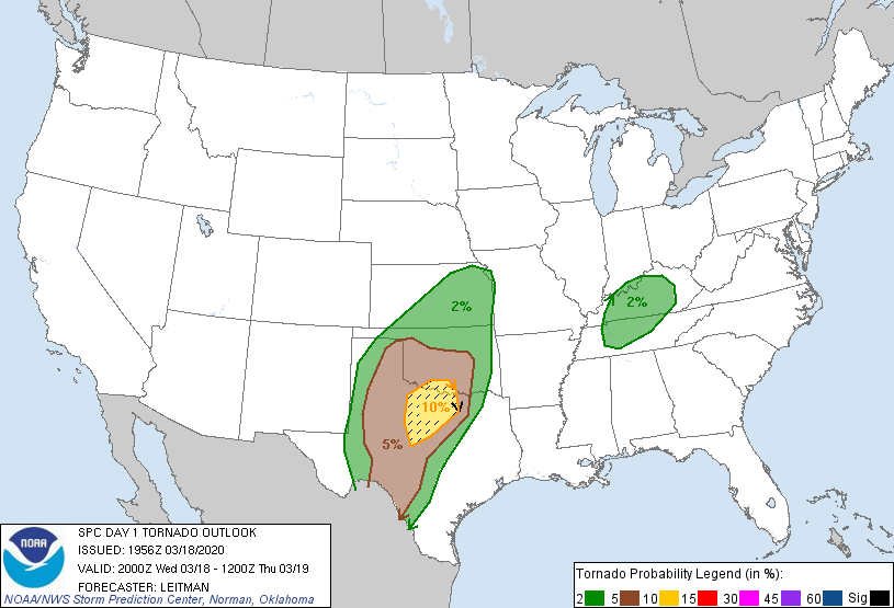
Probability of a tornado within 25 miles of a point. Hatched Area: 10% or greater probability of EF2 - EF5 tornadoes within 25 miles of a point.
Day 1 Tornado Risk
Area (sq. mi.)
Area Pop.
Some Larger Population Centers in Risk Area
SIG SEVERE
25,546
2,200,613
Fort Worth, TX...Abilene, TX...Wichita Falls, TX...Denton, TX...Lewisville, TX...
10 %
25,985
2,383,562
Fort Worth, TX...Abilene, TX...Wichita Falls, TX...Denton, TX...Lewisville, TX...
5 %
103,619
7,426,663
Dallas, TX...Oklahoma City, OK...Arlington, TX...Plano, TX...Garland, TX...
2 %
162,482
13,944,330
San Antonio, TX...Nashville, TN...Kansas City, MO...Tulsa, OK...Wichita, KS...
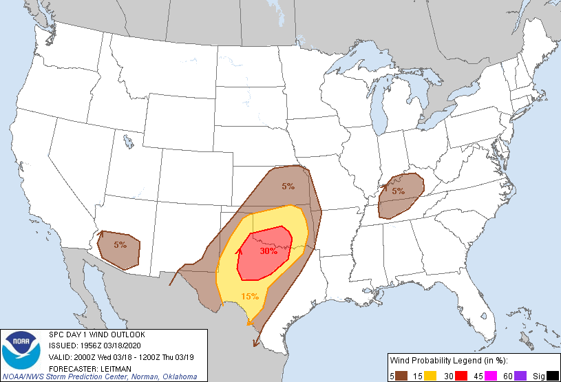
Probabilistic Damaging Wind Graphic
Probability of damaging thunderstorm winds or wind gusts of 50 knots or higher within 25 miles of a point. Hatched Area: 10% of greater probability of wind gusts 65 knots or greater within 25 miles of a point.
Day 1 Wind Risk
Area (sq. mi.)
Area Pop.
Some Larger Population Centers in Risk Area
30 %
56,658
3,402,086
Fort Worth, TX...Abilene, TX...Norman, OK...Wichita Falls, TX...Denton, TX...
15 %
115,942
8,446,088
Dallas, TX...Oklahoma City, OK...Tulsa, OK...Arlington, TX...Plano, TX...
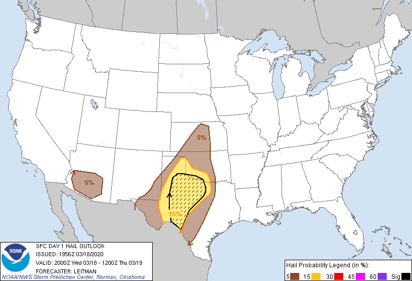
Probability of hail 1" or larger within 25 miles of a point. Hatched Area: 10% or greater probability of hail 2" or larger within 25 miles of a point.
Day 1 Hail Risk
Area (sq. mi.)
Area Pop.
Some Larger Population Centers in Risk Area
SIG SEVERE
64,581
1,033,751
Abilene, TX...Wichita Falls, TX...San Angelo, TX...Del Rio, TX...Big Spring, TX...
15 %
111,285
4,697,086
Fort Worth, TX...Arlington, TX...Lubbock, TX...Abilene, TX...Wichita Falls, TX...
5 %
170,473
16,327,748
Phoenix, AZ...San Antonio, TX...Dallas, TX...Austin, TX...Oklahoma City, OK...
SPC AC 181956
Day 1 Convective Outlook
NWS Storm Prediction Center Norman OK
0256 PM CDT Wed Mar 18 2020
Valid 182000Z - 191200Z
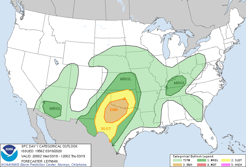
...THERE IS AN ENHANCED RISK OF SEVERE THUNDERSTORMS FROM
WEST-CENTRAL TEXAS INTO SOUTH-CENTRAL OKLAHOMA...
...SUMMARY...
Scattered severe thunderstorms are expected this afternoon through
tonight across parts of the southern and central Plains. Severe
wind gusts, large to very large hail, and tornadoes are possible.
...20z Update...
The outlook remains unchanged across the Plains with this update
cycle. The ongoing forecast remains on track and in-line with latest
guidance and surface observations. Reference MCD 193 for further
details on the short-term risk across parts of Texas.
The only change to probabilities has been the removal of the 2%
tornado area across southern AZ, where convection will likely remain
higher-based and low level shear only marginally favorable. The main
threat will continue to be isolated, marginally severe hail and
gusty winds.
..Leitman.. 03/18/2020
.PREV DISCUSSION... /ISSUED 1207 PM CDT Wed Mar 18 2020/
...Southern Plains region...
Primary change to previous outlook has been to increase tornado
probabilities across west central into northwest through north
central TX area. An old outflow boundary will persist in this
region, but should become more diffuse with time. Several CAM runs
and especially the HRRR continue to initiate storms in warm sector
by late afternoon initially along the dryline across west central
TX. This initiation would be in advance of primary zone of forcing
associated with the shortwave trough currently moving through
northern Mexico. While 0-1 km shear will initially be weak/modest,
an increase in the low-level jet during the early evening within an
otherwise favorable deep-layer shear environment will support
potential for supercells with low-level mesocyclones, tornadoes and
very large hail as storms move northeast toward central through
northwest and north central TX this evening. Otherwise additional
storms will likely develop across west TX along retreating dryline
during the evening and spread east through TX and OK during the
overnight. The shear/instability parameter space will support
organized storms with potential for linear/bowing segments as well
as supercells capable of all severe hazards.
...Arizona...
A strong shortwave trough will rotate northeast through AZ this
afternoon accompanied by steep lapse rates and strong vertical
shear. Though weak instability will remain a limiting factor, a few
storms could pose a threat for mainly locally strong wind gusts and
marginally severe hail.
...Tennessee through Ohio Valley region...
Strong vertical shear accompanying a shortwave trough has spread
across TN and KY, but widespread showers/rain continue to limit
overall destabilization potential. Will maintain a marginal risk for
this region for now, but threat appears very conditional.
CLICK TO GET WUUS01 PTSDY1 PRODUCT
NOTE: THE NEXT DAY 1 OUTLOOK IS SCHEDULED BY 0100Z