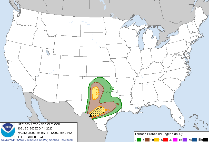
Probability of a tornado within 25 miles of a point. Hatched Area: 10% or greater probability of EF2 - EF5 tornadoes within 25 miles of a point.
Day 1 Tornado Risk
Area (sq. mi.)
Area Pop.
Some Larger Population Centers in Risk Area
SIG SEVERE
14,275
2,697,684
Austin, TX...Cedar Park, TX...San Marcos, TX...New Braunfels, TX...Schertz, TX...
10 %
33,585
3,710,159
San Antonio, TX...Austin, TX...Abilene, TX...Round Rock, TX...Cedar Park, TX...
5 %
70,637
2,805,537
Waco, TX...Killeen, TX...Wichita Falls, TX...Lawton, OK...San Angelo, TX...
2 %
87,405
14,650,915
Houston, TX...Dallas, TX...Fort Worth, TX...Oklahoma City, OK...Arlington, TX...
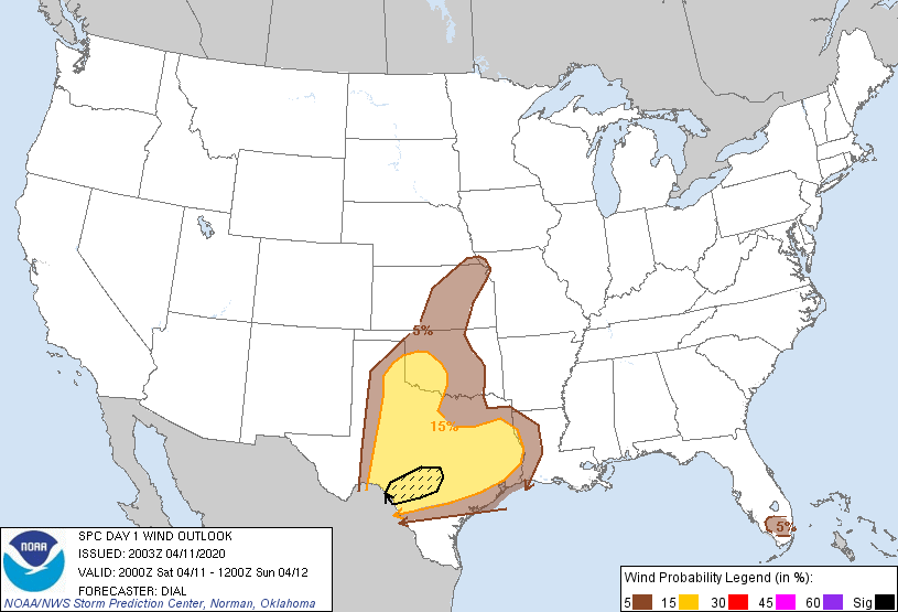
Probabilistic Damaging Wind Graphic
Probability of damaging thunderstorm winds or wind gusts of 50 knots or higher within 25 miles of a point. Hatched Area: 10% of greater probability of wind gusts 65 knots or greater within 25 miles of a point.
Day 1 Wind Risk
Area (sq. mi.)
Area Pop.
Some Larger Population Centers in Risk Area
SIG SEVERE
13,566
1,668,198
San Antonio, TX...Del Rio, TX...Kerrville, TX...Canyon Lake, TX...Uvalde, TX...
SPC AC 112003
Day 1 Convective Outlook
NWS Storm Prediction Center Norman OK
0303 PM CDT Sat Apr 11 2020
Valid 112000Z - 121200Z
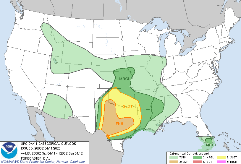
...THERE IS AN ENHANCED RISK OF SEVERE THUNDERSTORMS FROM SOUTHWEST
OKLAHOMA INTO WESTERN AND CENTRAL TEXAS...
...SUMMARY...
Severe thunderstorms are expected across parts of the southern Great
Plains, with the greatest threat during the late afternoon through
early morning from southwest Oklahoma into western and central
Texas. Very large hail, tornadoes, and scattered damaging winds will
be the primary hazards.
...Discussion...
Only minor adjustments to previous forecast have been made for this
update. Thunderstorms developing from northwest TX into southern OK
this afternoon will continue to pose a risk for a few tornadoes,
large hail and damaging wind.
Later tonight additional storms will likely develop from southwest
and western TX in association with an ejecting lead shortwave trough
and as an accompanying Pacific front merges with the dryline. These
storms will rapidly become severe as they move northeast and
intercept richer low-level moisture. The shear/instability parameter
space will favor for all severe hazards.
..Dial.. 04/11/2020
.PREV DISCUSSION... /ISSUED 1124 AM CDT Sat Apr 11 2020/
...Synopsis...
A closed mid-level low along the AZ/Sonora border will evolve into
an open wave as it reaches the TX Trans-Pecos and northeast
Chihuahua by early morning, in response to an upstream trough
digging southeast into the northern Rockies. At the surface, a lee
cyclone is expected to consolidate near the KS/CO border this
afternoon/evening. The lee cyclone will induce strengthening
southerly low-level flow and northward moisture transport across the
southern Great Plains, as the remnant front near the TX coast
advances north through tonight.
...North TX/southern OK to the Ark-La-Miss...
Elevated convection is ongoing across parts of north-central TX, in
a zone of low-level warm advection with increasing low-level
moisture from the west and southwest. This activity will have the
potential to produce isolated severe hail along the eastern edge of
the expanding buoyancy plume, as it continues east through the rest
of the period, eventually reaching the Ark-La-Miss region.
Farther west, pockets of greater boundary-layer heating within the
plume of upper 50s to mid 60s surface dew points will support a
broad swath of moderate buoyancy with MLCAPE reaching 1500-2500
J/kg. At least a few supercells are expected to develop across
northwest TX and spread into southwest OK and western North TX this
evening. The greatest coverage of severe should be from large hail,
but a couple tornadic supercells and isolated severe wind gusts will
be possible as well.
...Southern Edwards Plateau to central/east-central TX...
Severe storm development is expected across the southern Edwards
Plateau between 03-06Z as increasing height falls/forcing for ascent
encounter the strong buoyancy along the west edge of rather rich
low-level moisture. A couple intense supercells are expected roughly
from the Del Rio to San Antonio vicinity where all significant
severe hazards are possible. Upscale growth into a broader cluster
is likely into east-central TX through early morning. Very large
hail, a few tornadoes, and a swath of damaging winds will all be
possible from late evening through daybreak.
...Interior south FL...
A few thunderstorms are possible this afternoon as sea breeze
circulations interact with the remnant front. Isolated large hail
and damaging gusts may occur in an environment with MLCAPE of
1000-1500 J/kg and effective bulk shear near 50 kt.
CLICK TO GET WUUS01 PTSDY1 PRODUCT
NOTE: THE NEXT DAY 1 OUTLOOK IS SCHEDULED BY 0100Z