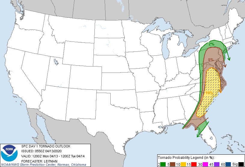
Philadelphia, PA...Jacksonville, FL...Baltimore, MD...Washington, DC...Virginia Beach, VA...
2 %
59,646
24,633,822
New York, NY...Charlotte, NC...Newark, NJ...Jersey City, NJ...Yonkers, NY...
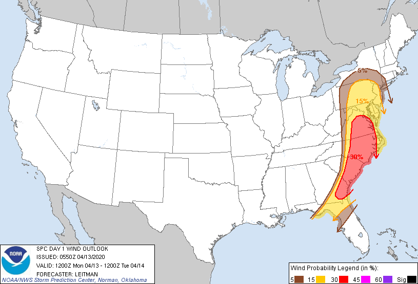
Probabilistic Damaging Wind Graphic
Probability of damaging thunderstorm winds or wind gusts of 50 knots or higher within 25 miles of a point. Hatched Area: 10% of greater probability of wind gusts 65 knots or greater within 25 miles of a point.
Philadelphia, PA...Jacksonville, FL...Baltimore, MD...Washington, DC...Virginia Beach, VA...
5 %
59,844
24,510,034
New York, NY...Charlotte, NC...Newark, NJ...Jersey City, NJ...Yonkers, NY...
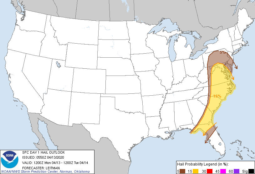
Probabilistic Large Hail Graphic
Probability of hail 1" or larger within 25 miles of a point. Hatched Area: 10% or greater probability of hail 2" or larger within 25 miles of a point.
Day 1 Hail Risk
Area (sq. mi.)
Area Pop.
Some Larger Population Centers in Risk Area
15 %
133,953
24,765,004
Jacksonville, FL...Baltimore, MD...Washington, DC...Virginia Beach, VA...Raleigh, NC...
5 %
68,401
18,335,586
Philadelphia, PA...Charlotte, NC...Winston-Salem, NC...Allentown, PA...Spring Hill, FL...
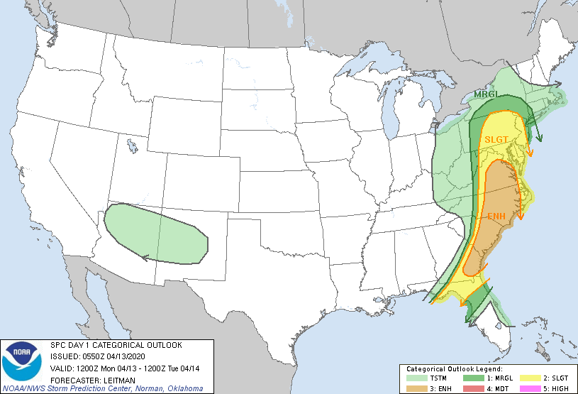
   SPC AC 130550

   Day 1 Convective Outlook
   NWS Storm Prediction Center Norman OK
   1250 AM CDT Mon Apr 13 2020

   Valid 131200Z - 141200Z

   ...THERE IS AN ENHANCED RISK OF SEVERE THUNDERSTORMS ACROSS
   SOUTHEAST GA INTO EASTERN SC/NC/VA THROUGH THIS AFTERNOON...

   ...SUMMARY...
   Severe thunderstorms capable of tornadoes, damaging wind gusts and
   hail are possible today from southeast Georgia through the eastern
   Caronlinas and into the Mid-Atlantic vicinity.

   ...Synopsis...
   A compact shortwave trough located over the Lower MS Valley as of
   05z this morning will continue lifting northeast toward the central
   Appalachians by the beginning of the forecast period. Intense
   south/southwesterly deep layer flow will overspread much of the
   Atlantic Coast from GA to the Mid-Atlantic vicinity.

   At the surface, rich Gulf moisture has spread northward across the
   region, with upper 60s to near 70 F dewpoints as far north as the
   SC/NC border as of 05z. Additional moistening is expected with
   northward extent, with near 60 F dewpoints making it as far north as
   southern NY potentially. Strong heating will likely be inhibited by
   widespread cloudiness ahead of ongoing lines/clusters of severe
   thunderstorms this morning. However, at least narrow corridors of
   moderate instability are forecast, aided by midlevel lapse rates
   approaching 7 C/km atop a very moist boundary layer, from the VA/NC
   Piedmont vicinity southward into eastern GA and eastward toward the
   coast. In the presence of intense shear, with large, curved
   low-level hodographs, rotating cells embedded in an
   east/northeastward developing line of storms will result in a
   tornado and damaging wind threat through at least midday. A few
   intense, long-track supercells capable of producing strong tornadoes
   will be possible, mainly from the VA/NC into eastern SC and
   southeast GA.

   While the best overlap of thermodynamic and kinematics will exist
   across southeast GA to eastern VA/NC, a severe threat will extend
   northward from the Chesapeake Bay vicinity into much of PA, southern
   NY into NJ and the Long Island vicinity. A 50+ kt southerly low
   level jet will quickly be overspreading this area during the morning
   while at least weak instability develops with increasing low level
   moisture. A mix of fast-moving cells and bowing line segments are
   expected to pose mainly a damaging wind threat. However, forecast
   low level shear will support a tornado threat with any surface-based
   storms. The best chance for surface-based convection will occur
   where pockets of stronger heating can occur.

   Convection should generally move offshore the GA to Carolinas coast
   by early afternoon. Further north, storms will develop later and
   further west, and should move offshore by 21-00z. However, the
   surface cold front will linger across northern FL, and additional
   thunderstorms could develop overnight as a southern stream wave
   tracks northeast across the Gulf and over the northern Peninsula.
   These storms could pose a severe threat, through vertical shear and
   midlevel lapse rates will not be as favorable as earlier in the day.

   ..Leitman.. 04/13/2020

   CLICK TO GET WUUS01 PTSDY1 PRODUCT

   NOTE: THE NEXT DAY 1 OUTLOOK IS SCHEDULED BY 1300Z