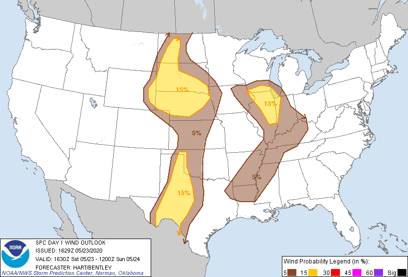
Probability of damaging thunderstorm winds or wind gusts of 50 knots or higher within 25 miles of a point. Hatched Area: 10% of greater probability of wind gusts 65 knots or greater within 25 miles of a point.
SPC AC 231629
Day 1 Convective Outlook
NWS Storm Prediction Center Norman OK
1129 AM CDT Sat May 23 2020
Valid 231630Z - 241200Z
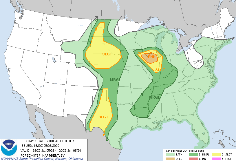
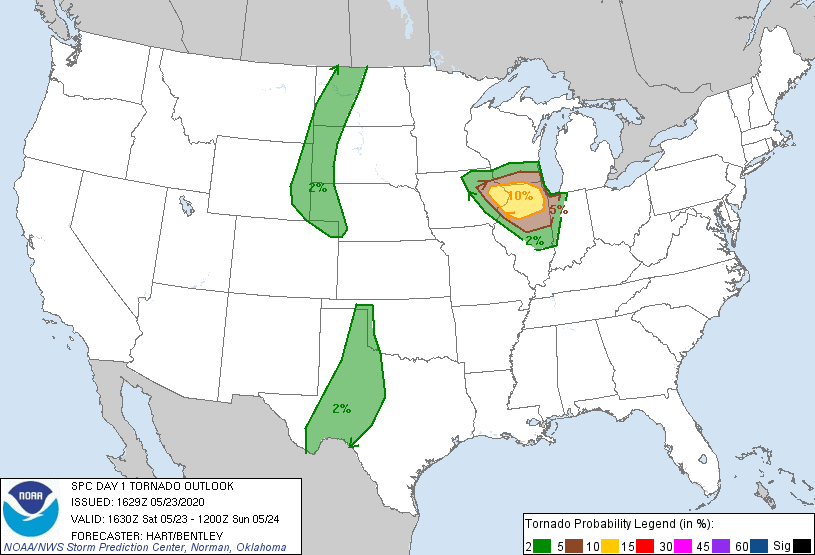
...THERE IS AN ENHANCED RISK OF SEVERE THUNDERSTORMS THIS AFTERNOON
OVER PORTIONS OF NORTHERN ILLINOIS AND EASTERN IOWA...
...THERE IS A SLIGHT RISK OF SEVERE THUNDERSTORMS OVER MUCH OF THE
PLAINS STATES....
...SUMMARY...
Scattered severe thunderstorms, some with tornadoes, will cross
parts of eastern Iowa, northern Illinois and southern Wisconsin from
midday through this afternoon. Thunderstorms with very large hail
and severe wind will affect parts of the northern and southern Great
Plains.
...Northern IL and Vicinity...
An upper low is rotating eastward across IA this morning. The
latest surface analysis has a low near Des Moines, with the a cold
front extending southward into northern MO. Southeasterly low-level
winds to the east of the low across eastern IA and northern IL are
enhancing vertical shear and resulting in favorable hodograph
structures for rotating storms later today. Visible satellite
imagery shows considerable daytime heating is occurring over much of
this region, which combined with dewpoints in the 60s will yield
afternoon MLCAPE values of 1000-1500 J/kg. All of these parameters
lend to the potential for active severe weather later today.
Current indications are that storms will form along/ahead of the
cold front and spread across the ENH risk area this afternoon.
Discrete storm mode appears likely, resulting in multiple
supercells. A few tornadoes are expected, along with large hail and
damaging wind gusts. Activity should approach the Chicago/Milwaukee
areas this evening.
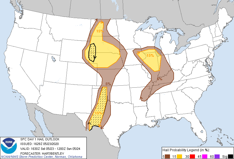
...TX...
A strong dryline is expected to form this afternoon across west TX,
with full daytime heating and dewpoints in the mid 60s expected to
the east of the boundary. Current indications are that the cap will
sufficiently weaken to allow scattered thunderstorms to form by
mid-late afternoon from the Panhandle southward into the eastern
Permian Basin. Low-level winds are not particularly strong, but
sufficient deep-layer shear and ample CAPE (MLCAPE of 3500+ J/kg)
will pose a risk of supercells capable of very large hail and
damaging winds. This activity will spread into central TX and
perhaps western OK tonight before weakening.
...Northern Plains...
Water vapor imagery shows an upper trough moving across the northern
Rockies. This feature will help to promote thunderstorm development
over eastern WY into the western Dakotas/NE and northeast CO by
mid-late afternoon. Multiple lines and clusters of storms will
affect this region through the evening, with a risk of large hail
and damaging winds over a relatively large area. The evolution of
the storms tonight is unclear, but the pattern would be favorable
for one or more bowing complexes maintaining intensity into parts of
central/eastern NE/SD.
..Hart/Bentley.. 05/23/2020
CLICK TO GET WUUS01 PTSDY1 PRODUCT
NOTE: THE NEXT DAY 1 OUTLOOK IS SCHEDULED BY 2000Z