Probability of a tornado within 25 miles of a point. Hatched Area: 10% or greater probability of EF2 - EF5 tornadoes within 25 miles of a point.
Day 1 Tornado Risk
Area (sq. mi.)
Area Pop.
Some Larger Population Centers in Risk Area
No Risk Areas Forecast
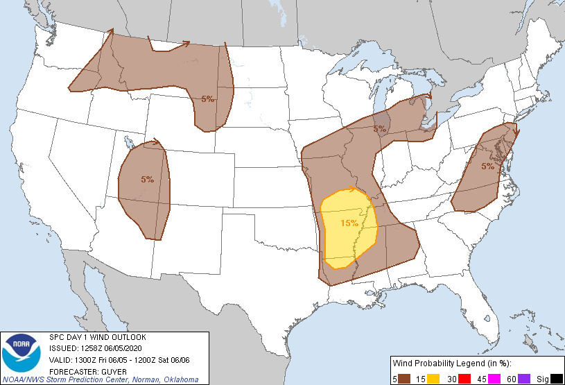
Probabilistic Damaging Wind Graphic
Probability of damaging thunderstorm winds or wind gusts of 50 knots or higher within 25 miles of a point. Hatched Area: 10% of greater probability of wind gusts 65 knots or greater within 25 miles of a point.
Day 1 Wind Risk
Area (sq. mi.)
Area Pop.
Some Larger Population Centers in Risk Area
15 %
92,479
5,659,476
Memphis, TN...Little Rock, AR...Springfield, MO...North Little Rock, AR...Jonesboro, AR...
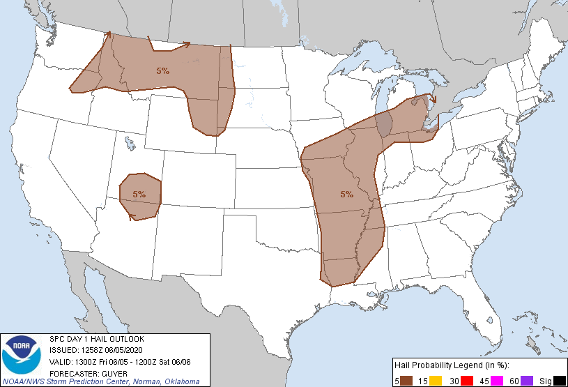
Probability of hail 1" or larger within 25 miles of a point. Hatched Area: 10% or greater probability of hail 2" or larger within 25 miles of a point.
Day 1 Hail Risk
Area (sq. mi.)
Area Pop.
Some Larger Population Centers in Risk Area
5 %
571,560
44,114,367
Chicago, IL...Detroit, MI...Memphis, TN...Milwaukee, WI...Kansas City, MO...
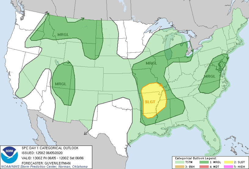
   SPC AC 051258

   Day 1 Convective Outlook
   NWS Storm Prediction Center Norman OK
   0758 AM CDT Fri Jun 05 2020

   Valid 051300Z - 061200Z

   ...THERE IS A SLIGHT RISK OF SEVERE THUNDERSTORMS ACROSS THE
   MID-SOUTH AND LOWER/MIDDLE MISSISSIPPI VALLEY...

   ...SUMMARY...
   Severe thunderstorms are possible today into tonight across the
   Ozarks/Mid-South and Middle/Lower Mississippi Valley. Other strong
   to severe thunderstorms may occur over the Northern Rockies and
   adjacent High Plains, the Mid-Atlantic States, as well as the Four
   Corners area.

   ...Ozarks/Mid-South and Lower/Middle Mississippi Valley...
   East/southeastward-moving elevated convection via merged two
   overnight MCSs will continue toward/across the middle Mississippi
   River area this morning. Although these storms will tend to spread
   away from the greater instability, a locally severe storm or two
   could occur this morning with hail and possibly a few strong wind
   gusts. Into the afternoon, MCV-related ascent will approach the
   confluence of the Mississippi/Ohio Rivers and nearby Mid-South,
   where it will encounter a moist/strongly unstable air mass to the
   south of MCS-residual cloud cover/outflow. Severe storm development
   is possible in the from of a south/southeastward-moving storm
   clusters. Wind damage would be the primary hazard, but some hail is
   possible as well given the degree of instability.

   ...Northern Rockies and adjacent High Plains...
   An upper ridge will continue to build northward through the High
   Plains. However, a belt of stronger westerlies will persist over the
   Northern Rockies downstream from an approaching upper trough. While
   low-level moisture will be somewhat limited, steep lapse rates and
   diabatic warming will contribute to 500-1500 J/kg MLCAPE. A series
   of vorticity maxima will move northeast through this region along
   northwestern periphery of the building ridge, and at least isolated
   storms are expected to develop over the higher terrain and spread
   northeast into the adjacent Plains. Vertical wind profiles with 40+
   kt effective bulk shear will support potential for a few/isolated
   high-based supercells with large hail and locally strong to severe
   wind gusts.

   ...Middle Atlantic States/Carolinas...
   Storms will likely once again develop over the higher terrain this
   afternoon and spread generally eastward within a moderately unstable
   air mass (1500-2000 J/kg MLCAPE) east of the mountains. Such
   development will be aided by a weak mid-level impulse approaching
   the central Appalachians this afternoon. While wind profiles will
   not be overly strong (effective shear generally 20-25 kt),
   steepening low-level lapse rates will support some sustained
   multicells. Locally damaging wind gusts will be the primary risk.

   ...Great Basin/Four Corners Area...
   Mid/upper-level winds and forcing for ascent will increase across
   the region this afternoon through tonight as a shortwave trough
   ejects northeastward over southern California/northern Baja.
   Scattered thunderstorms are likely to develop this afternoon across
   northern Arizona/northwest New Mexico into Utah/western Colorado.
   Deeply mixed boundary layer profiles in the presence of
   strengthening mid-level winds will be conducive for some
   severe-caliber thunderstorm wind gusts, particularly late this
   afternoon and early evening. Later tonight, the arrival of stronger
   forcing for ascent and increasing moisture should allow for a
   continuation/redevelopment of thunderstorms across parts of the
   region. Weak buoyancy and appreciably strengthening deep-layer shear
   suggests a few strong storms could occur tonight, potentially with
   some hail/wind risk.

   ..Guyer/Leitman.. 06/05/2020

   CLICK TO GET WUUS01 PTSDY1 PRODUCT

   NOTE: THE NEXT DAY 1 OUTLOOK IS SCHEDULED BY 1630Z