Probability of damaging thunderstorm winds or wind gusts of 50 knots or higher within 25 miles of a point. Hatched Area: 10% of greater probability of wind gusts 65 knots or greater within 25 miles of a point.
Grand Forks, ND...North Platte, NE...Aberdeen, SD...Brookings, SD...Bemidji, MN...
5 %
66,036
910,621
Sioux Falls, SD...Kearney, NE...Willmar, MN...Hibbing, MN...Jamestown, ND...
SPC AC 080555
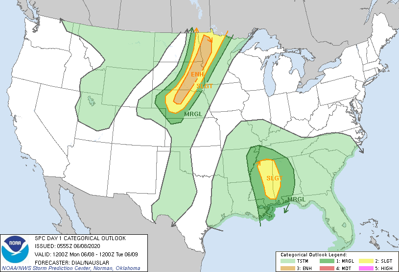
Day 1 Convective Outlook
NWS Storm Prediction Center Norman OK
1255 AM CDT Mon Jun 08 2020
Valid 081200Z - 091200Z
...THERE IS AN ENHANCED RISK OF SEVERE THUNDERSTORMS ACROSS A
PORTION OF THE CENTRAL AND NORTHERN PLAINS INTO NORTHWEST
MINNESOTA...
...THERE IS A SLIGHT RISK OF SEVERE THUNDERSTORMS ACROSS A PORTION
OF THE CENTRAL AND NORTHERN PLAINS INTO NORTHWEST MINNESOTA AS WELL
AS EASTERN MISSISSIPPI AND WESTERN ALABAMA...
...SUMMARY...
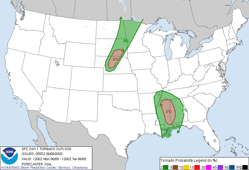
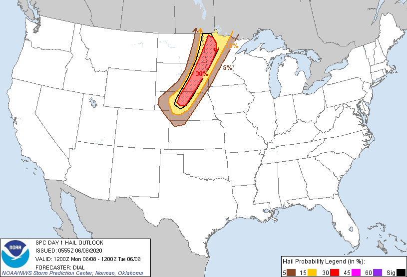
Scattered severe storms with damaging wind and large hail are
expected along and ahead of a cold front across a portion of the
northern and central plains. Remnants of Cristobal may pose a risk
for a few tornadoes across parts of Mississippi and Alabama Monday.
...Central through northern Plains region...
Thunderstorms ongoing over the northern Plains should diminish
through early morning as deeper ascent accompanying a leading
shortwave trough crosses into southern Canada. In wake of this
feature, a synoptic trough currently situated over the northern
Rockies will advance slowly east while several vorticity maxima
rotate through this feature and eventually into the central and
northern High Plains later today. A cold front will be situated
across the western Dakotas early today and will advance through much
of the Dakotas by early evening. The southwestern extension of this
boundary is forecast to temporarily stall across NE as a lee low
develops over northwest KS just downstream of a more significant
impulse that will move through the base of the synoptic trough.
Boundary layer dewpoints generally in the low to mid 60s F will
persist in pre-frontal warm sector beneath steep (7.5-8 C/km)
mid-level lapse rates, and the atmosphere should once again become
moderately unstable as the surface layer warms with 2000-2500 J/kg
MLCAPE expected by mid to late afternoon. A capping inversion and
weak forcing will inhibit thunderstorm development most of the day,
but storms are expected to initiate within zone of deeper forcing
along the cold front by late afternoon across the central and
eastern Dakotas, eventually spreading into northwest MN. A belt of
stronger winds aloft will support 40-50 kt largely unidirectional
effective bulk shear with supercells likely to be the initial storm
mode before storms begin to evolve into lines and clusters. Damaging
wind and large hail are the primary threats. There may be a small
window for a couple of tornadoes during the evening as the low-level
jet strengthens and before the boundary layer stabilizes and storms
begin to grow upscale.
...Eastern Mississippi and western Alabama into west Tennessee...
Remnants of Cristobal is forecast by the National Hurricane center
to advance generally northward through the lower MS Valley region,
reaching southern AR by late Monday night. Vertical wind profiles
with large low-level hodographs will remain supportive of a few
low-topped supercells capable of isolated tornadoes east and
northeast of the center, especially during the afternoon when some
boundary layer destabilization will be possible between the outer
convective rain bands.
..Dial/Nauslar.. 06/08/2020
CLICK TO GET WUUS01 PTSDY1 PRODUCT
NOTE: THE NEXT DAY 1 OUTLOOK IS SCHEDULED BY 1300Z