Probability of damaging thunderstorm winds or wind gusts of 50 knots or higher within 25 miles of a point. Hatched Area: 10% of greater probability of wind gusts 65 knots or greater within 25 miles of a point.
Grand Forks, ND...North Platte, NE...Aberdeen, SD...Brookings, SD...Alexandria, MN...
5 %
73,058
1,024,964
Sioux Falls, SD...Kearney, NE...Willmar, MN...Hibbing, MN...Jamestown, ND...
SPC AC 082002
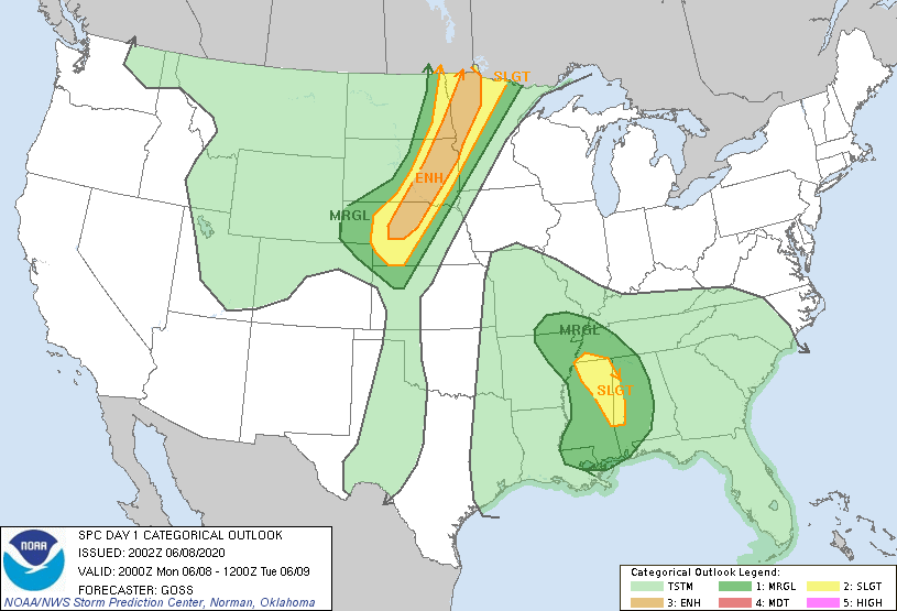
Day 1 Convective Outlook
NWS Storm Prediction Center Norman OK
0302 PM CDT Mon Jun 08 2020
Valid 082000Z - 091200Z
...THERE IS AN ENHANCED RISK OF SEVERE THUNDERSTORMS FROM
NORTHWESTERN MN SOUTHWESTWARD TO NORTH-CENTRAL NEB...
...THERE IS A SLIGHT RISK OF SEVERE THUNDERSTORMS ACROSS PORTIONS OF
THE CENTRAL GULF COAST STATES/TN VALLEY...
...SUMMARY...
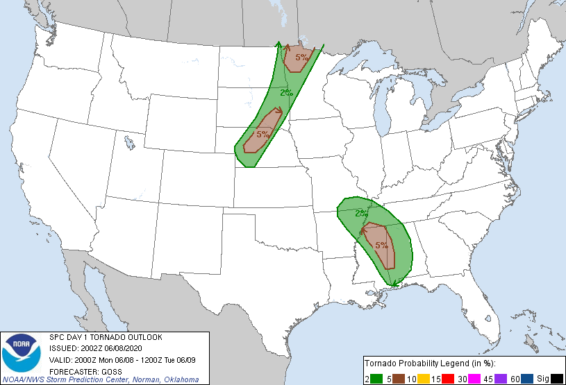
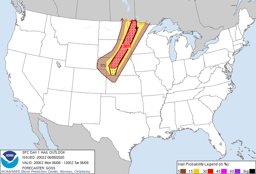
Scattered severe thunderstorms are likely late this afternoon into
tonight across parts of Nebraska and the eastern Dakotas into
western/northern Minnesota. The remnants of Cristobal may pose a
risk for a few tornadoes across parts of Mississippi, Alabama, and
the Mid-South region.
...Discussion...
No appreciable changes appear necessary at this time, with respect
to the ongoing outlook. Widespread convection is ongoing in the
vicinity of remnant Tropical Depression Cristobal, with potential
for locally gusty/damaging winds and a tornado or two apparent
within roughly the eastern quadrant of the low.
Meanwhile, storms have begun to develop over northeastern North
Dakota, with additional development expected south-southwestward
along the cold front over the next few hours. For additional
short-term information, please refer to SWOMCD 881, and newly issued
WW 270.
..Goss.. 06/08/2020
.PREV DISCUSSION... /ISSUED 1126 AM CDT Mon Jun 08 2020/
...Central/northern Plains late this afternoon into tonight...
As part of an amplified pattern across the CONUS, the primary
midlevel trough over NV/UT will progress slowly eastward to
CO/northern NM overnight. Expect a slow-moving surface cold front
to stall today across NE, in response to lee cyclogenesis across the
central High Plains, in advance of the UT/NV midlevel trough. This
front will serve as the primary focus for severe storm development.
Beneath a remnant EML, boundary-layer dewpoints will range from the
low-mid 60s along the front in central NE to the upper 60s along the
eastern ND/MN border region. Surface heating/mixing in the warm
sector, along with low-level ascent along the front, will support
thunderstorm development late this afternoon into this evening from
central NE to the eastern Dakotas/western MN.
MLCAPE is expected to reach the 2000-3000 J/kg range by late
afternoon along the front, in an environment with effective bulk
shear in excess of 40 kt. Largely straight hodographs with
relatively weak low-level shear/hodograph curvature will support
supercells with the primary threats of large hail initially. Some
upscale growth and increase in the damaging-wind threat is expected
this evening due to storm interactions, with deep-layer
south-southwesterly flow will largely parallel the slow-moving
front. The overall tornado threat is more in question given the
weak low-level shear this afternoon. A relatively greater tornado
threat is possible in the greater low-level moisture with initial
storm development in the vicinity of northwest MN this evening, and
across central NE where some backing and strengthening of low-level
flow is expected by late evening/early tonight, east of the
deepening lee cyclone.
...MS/AL/TN/AR/MO through tonight...
The weakening remnants of tropical cyclone Cristobal will continue
to move generally northward across the Ark-La-Miss to southern MO
overnight, with a gradual acceleration in response to an approaching
midlevel trough over the central High Plains. Regional 12z
soundings revealed 500 mb temperatures of -1 to -2 C with the warm
core system, which will tend to limit buoyancy in proximity to the
cyclone core. Surface heating in cloud breaks in the vicinity of
the main eastern band (near the MS/AL border), which is also
coincident with a belt of 40-50 kt low-midlevel flow, could support
a isolated supercells this afternoon. Observed and forecast
hodographs only show modest low-level curvature/SRH, so it appears
the tornado threat can be characterized as somewhat marginal.
The tropical air mass across the Gulf coast states will slowly
spread northward with Cristobal, replacing the relatively dry air
now present to the north of TN. It is not clear if the increases in
moisture/weak buoyancy and vertical shear will be sufficient for
rotating storms on the north-northeast periphery of the circulation
this afternoon into southeast MO. After the loss of daytime
heating, the threat for supercells should diminish slowly, but not
completely end in the moist environment.
CLICK TO GET WUUS01 PTSDY1 PRODUCT
NOTE: THE NEXT DAY 1 OUTLOOK IS SCHEDULED BY 0100Z