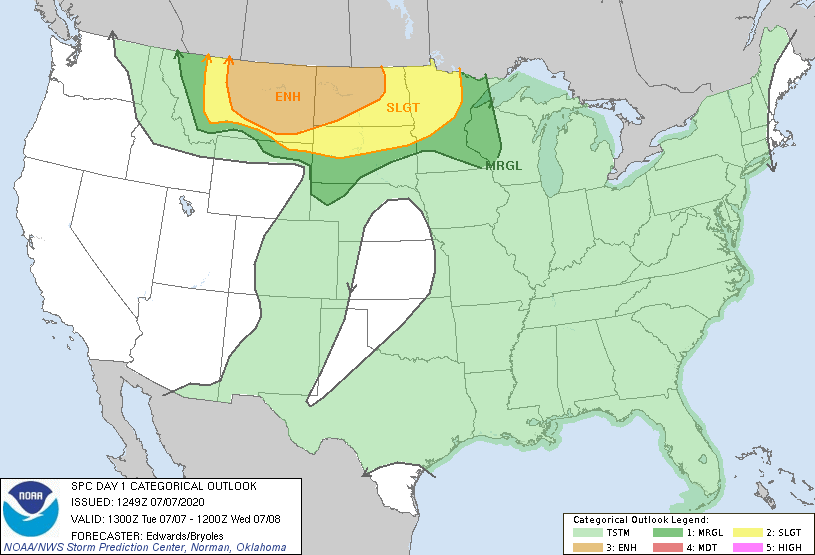
Probability of a tornado within 25 miles of a point. Hatched Area: 10% or greater probability of EF2 - EF5 tornadoes within 25 miles of a point.
Day 1 Tornado Risk
Area (sq. mi.)
Area Pop.
Some Larger Population Centers in Risk Area
5 %
57,418
99,018
Havre, MT...Miles City, MT...Lewistown, MT...Glendive, MT...
2 %
168,459
1,607,982
Billings, MT...Fargo, ND...Rapid City, SD...Bismarck, ND...Great Falls, MT...
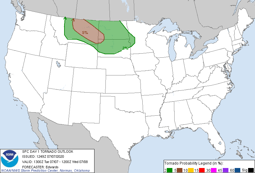
Probabilistic Damaging Wind Graphic
Probability of damaging thunderstorm winds or wind gusts of 50 knots or higher within 25 miles of a point. Hatched Area: 10% of greater probability of wind gusts 65 knots or greater within 25 miles of a point.
   SPC AC 071249

   Day 1 Convective Outlook
   NWS Storm Prediction Center Norman OK
   0749 AM CDT Tue Jul 07 2020

   Valid 071300Z - 081200Z

   ...THERE IS AN ENHANCED RISK OF SEVERE THUNDERSTORMS OVER PARTS OF
   CENTRAL/EASTERN MONTANA AND WESTERN/CENTRAL NORTH DAKOTA...

   ...SUMMARY...
   Severe storms capable of intense damaging winds, large hail and a
   few tornadoes are expected from central Montana eastward across the
   northern Plains and into Minnesota, today into tonight.

   ...Synopsis...
   The main upper-air feature for this forecast cycle is a synoptic
   trough, located initially from southern BC southward across the
   interior Pacific Northwest States to central CA. The northern part
   of this trough should evolve into a closed 500-mb cyclone over the
   Canadian Rockies by 00Z, which will move eastward over southern AB
   through the remainder of this period.  As that occurs, a shortwave
   perturbation -- now apparent in moisture-channel imagery over
   central/eastern parts of WA/OR -- will eject east-northeastward over
   MT.

   By 00Z, this trough should reach southeastern AB and west-central/
   southwestern MT.  The primary associated vorticity max is progged to
   eject toward southwestern SK overnight -- albeit with some track/
   timing uncertainty due to upscale-growing convective processes
   discussed below that may result in a dominant MCV.  Elsewhere, a
   broad, baggy weakness in the height field across the east-central/
   southeastern CONUS will contain several slow-moving perturbations
   and MCVs, supporting general-thunderstorm potential amidst weak
   deep-layer flow and lack of vertical shear.

   At the surface, 11Z analysis showed an outflow boundary from the
   prior/overnight MCS, in an arc from southwestern NM across north-
   central/southwestern IA, and southern to northwestern NE.  This
   feature is expected to shift back northward across NE and portions
   of SD through this evening, becoming more diffuse with time.  Cold
   frontogenesis and related low-level cyclogenesis, over the northern
   Rockies this morning into afternoon, will shift out across the
   plains of MT/northern WY through the remainder of the afternoon into
   evening.  By 00Z, the main surface low should be located near the
   northern Black Hills, along a front arching from there northwestward
   over eastern MT, and southwestward across south-central/southwestern
   WY.  The low should pivot northeastward to east-central ND by around
   12Z, with cold front southwestward across central SD, the NE
   Panhandle and northern CO.

   ...Northern High Plains to MN...
   Thunderstorms are expected to develop initially over the mountains
   near the MT/ID border, closest to the large-scale DCVA/lift that
   precedes the progressive Pacific Northwest trough.  Low/middle-level
   lapse rates should steepen throughout the day over western MT from
   that process, with weakening MLCINH and increasing boundary-layer
   lapse rates related to diabatic heating.  With time and eastward
   extent through the afternoon, this will support additional, widely
   scattered to scattered thunderstorm development across other higher
   terrain and foothills of southern MT and extreme northern WY,
   eastward past the Bighorns.  Activity should encounter increasing
   moisture, but also, well-mixed subcloud layers, as it moves
   northeastward into a diurnally destabilizing inflow layer.

   The severe threat will evolve largely according to storm mode.  A
   time window of uncertain duration exists for initial convection to
   evolve into supercells, offering large to very large hail and severe
   gusts.  A few tornadoes may occur as well, particularly from
   north-central/central MT into portions of the western Dakotas, as
   moisture advection continues, LCLs lower some with eastward extent,
   and a reservoir of residual low-level vorticity may linger near and
   just north of the western extent of the old outflow boundary.
   Strengthening deep shear is expected across the northern High Plains
   as the mid/upper trough approaches,

   Meanwhile, areas of strong afternoon heating and sufficient moisture
   (remaining behind previous days' convective activity) will support
   peak preconvective MLCAPE ranging from around 1500-2000 J/kg in
   central MT to nearly 4000 J/kg over north-central/northeastern SD,
   along and north of the diffuse boundary.  A very conditional,
   isolated but potentially significant severe threat in all forms may
   occur in central/north-central SD near the retreating boundary, late
   this afternoon into evening, where very large hodographs and rich
   moisture are forecast. However, initiation remains in doubt during
   daylight to early evening hours that far east, due to capping and
   lack of stronger deep-layer lift.

   One or two MCSs are expected to evolve from the earlier convection
   and move across central/eastern MT, much of ND and perhaps northern
   SD.  As this occurs, the main severe threat transitions to damaging
   wind -- some of which locally may exceed hurricane force (65+ kt,
   significant severe).  A broad, 50-60-kt LLJ should develop over the
   Dakotas and northern NE overnight, with associated theta-e advection
   and moisture transport above the surface supporting MCS maintenance
   across the northern Plains, reaching parts of northwestern and
   perhaps far northern MN late tonight.

   ..Edwards/Bryoles.. 07/07/2020

   CLICK TO GET WUUS01 PTSDY1 PRODUCT

   NOTE: THE NEXT DAY 1 OUTLOOK IS SCHEDULED BY 1630Z