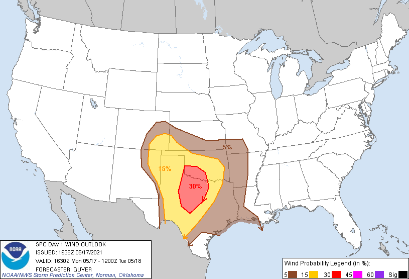
Houston, TX...Dallas, TX...Fort Worth, TX...Oklahoma City, OK...Arlington, TX...
Probabilistic Damaging Wind Graphic
Probability of damaging thunderstorm winds or wind gusts of 50 knots or higher within 25 miles of a point. Hatched Area: 10% of greater probability of wind gusts 65 knots or greater within 25 miles of a point.
Day 1 Wind Risk
Area (sq. mi.)
Area Pop.
Some Larger Population Centers in Risk Area
30 %
51,094
2,336,469
Fort Worth, TX...Abilene, TX...Wichita Falls, TX...Denton, TX...Lawton, OK...
15 %
185,592
11,965,750
Dallas, TX...Oklahoma City, OK...Arlington, TX...Plano, TX...Garland, TX...
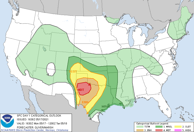
SPC AC 171638
Day 1 Convective Outlook
NWS Storm Prediction Center Norman OK
1138 AM CDT Mon May 17 2021
Valid 171630Z - 181200Z
...THERE IS A MODERATE RISK OF SEVERE THUNDERSTORMS ACROSS
WEST/SOUTHWEST TEXAS...
...SUMMARY...
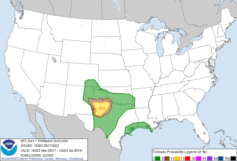
Severe thunderstorms are likely across the southern Plains this
afternoon and tonight. The potential for very large hail, a few
tornadoes, and damaging winds will be focused across a broad part of
west/northwest Texas.
...West/southwest/north Texas and southwest Oklahoma...
An active severe-weather day is expected particularly across
west/southwest Texas later this afternoon/evening. In the base of an
eastward-moving upper trough, an east/northeastward-ejecting
high-level jet analyzed over northern Mexico this morning will reach
the southern High Plains by around peak heating/early evening,
leading to a further strengthening of mid/high-level westerlies that
are already seasonally strong (12Z Midland TX observed sounding).
Related to convection overnight/early this morning across the Low
Rolling Plains and north-central Texas, an outflow boundary
continues to settle/decelerate south into the Permian Basin/Concho
Valley including Midland/San Angelo areas, east-southeastward toward
the Texas Hill Country. Considerable convective overturning and
stabilization has occurred in association with this
convection/outflow across the Low Rolling Plains and western North
Texas, although steady modification/northward mixing of the boundary
should occur especially across the Permian Basin and West Texas
South Plains later today. It is in relative proximity to this
boundary and the north/south-oriented dry line that will have the
highest probability of intense surface-based storm development later
today. Intense heating/ample convergence will likely lead to such
development by late afternoon.
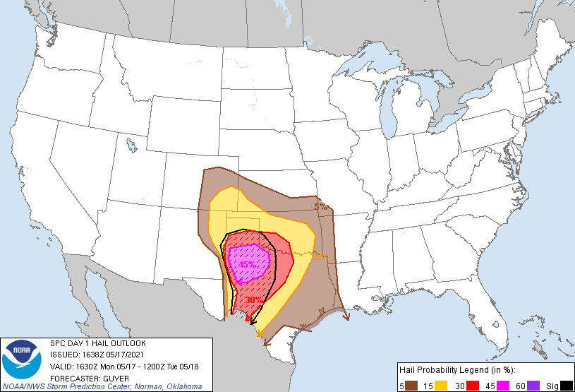
These storms will move into an environment of very high instability
(MLCAPE over 3000 J/kg), steep mid level lapse rates exceeding 8.0
C/km, and effective shear values of 40-50 kt. Intense supercells
capable of very large hail (some hailstones in excess of 3" in
diameter are viable) are expected, particularly within the Moderate
Risk area across west/southwest Texas. Although low-level winds are
not forecast to be overly strong, the residual influence of the
outflow boundary and robust instability will support the possibility
of a few tornadoes. Over time, storms should eventually
cluster/organize this evening toward the Low Rolling Plains/Big
Country with damaging wind potential also increasing as storms
progress east-southeastward.
...Southeast Colorado/south-central High Plains...
A moist post-frontal environment in conjunction with low-level
upslope flow will be conducive for at least isolated severe
thunderstorms by mid/late afternoon initially across southeast
Colorado/northeast New Mexico including the Raton Mesa vicinity.
Although deep-layer shear will not strong, organized multicells and
some transient supercells can be expected with large hail and
possibly some tornado risk. These storms should move into additional
parts of the region including the Texas/Oklahoma Panhandles and
southwest Kansas by early evening with mostly a hail/wind risk
continuing.
...Southeast Texas/western Louisiana...
A loosely organized cluster of storms persist across southeast Texas
into western/southern Louisiana late this morning. While deep-layer
shear and buoyancy are not overly strong, the moist environment and
relatively strong low-level shear/SRH have been supportive of
transient supercell circulations. This risk may continue this
afternoon with at least some potential for a brief tornado and/or
locally damaging wind gust, particularly in areas closer to the
immediate coast.
..Guyer/Marsh.. 05/17/2021
CLICK TO GET WUUS01 PTSDY1 PRODUCT
NOTE: THE NEXT DAY 1 OUTLOOK IS SCHEDULED BY 2000Z