San Antonio, TX...Dallas, TX...Austin, TX...Fort Worth, TX...Arlington, TX...
MARGINAL
301,210
19,807,494
Houston, TX...Kansas City, MO...Tulsa, OK...Corpus Christi, TX...Lubbock, TX...
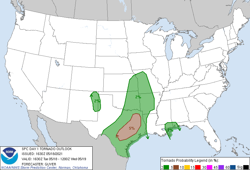
Probabilistic Tornado Graphic
Probability of a tornado within 25 miles of a point. Hatched Area: 10% or greater probability of EF2 - EF5 tornadoes within 25 miles of a point.
Day 1 Tornado Risk
Area (sq. mi.)
Area Pop.
Some Larger Population Centers in Risk Area
5 %
47,295
7,522,914
San Antonio, TX...Austin, TX...Waco, TX...Killeen, TX...Tyler, TX...
2 %
273,613
25,675,270
Houston, TX...Dallas, TX...Fort Worth, TX...Kansas City, MO...Tulsa, OK...
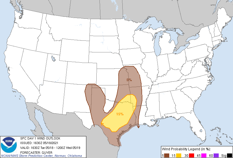
Probabilistic Damaging Wind Graphic
Probability of damaging thunderstorm winds or wind gusts of 50 knots or higher within 25 miles of a point. Hatched Area: 10% of greater probability of wind gusts 65 knots or greater within 25 miles of a point.
Day 1 Wind Risk
Area (sq. mi.)
Area Pop.
Some Larger Population Centers in Risk Area
15 %
108,285
15,635,993
San Antonio, TX...Dallas, TX...Austin, TX...Fort Worth, TX...Arlington, TX...
5 %
279,313
18,130,675
Houston, TX...Kansas City, MO...Tulsa, OK...Corpus Christi, TX...Lubbock, TX...
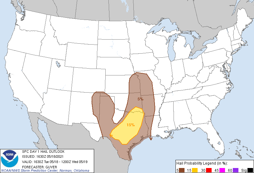
Probabilistic Large Hail Graphic
Probability of hail 1" or larger within 25 miles of a point. Hatched Area: 10% or greater probability of hail 2" or larger within 25 miles of a point.
Day 1 Hail Risk
Area (sq. mi.)
Area Pop.
Some Larger Population Centers in Risk Area
15 %
87,631
13,323,800
San Antonio, TX...Dallas, TX...Austin, TX...Fort Worth, TX...Arlington, TX...
5 %
301,718
20,376,804
Houston, TX...Kansas City, MO...Tulsa, OK...Corpus Christi, TX...Lubbock, TX...
SPC AC 181630
Day 1 Convective Outlook
NWS Storm Prediction Center Norman OK
1130 AM CDT Tue May 18 2021
Valid 181630Z - 191200Z
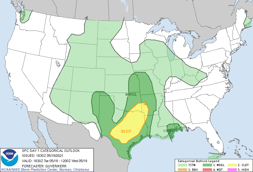
...THERE IS A SLIGHT RISK OF SEVERE THUNDERSTORMS ACROSS
SOUTH-CENTRAL/EAST TEXAS TO SOUTHEAST OKLAHOMA/ARKLATEX...
...SUMMARY...
Severe thunderstorms, including the risk for large hail, damaging
winds, and a couple of tornadoes are expected mainly across
south-central and east Texas toward the ArkLaTex region this
afternoon through evening.
...Central/east Texas to ArkLaTex region...
An upper low centered over New Mexico/southern Colorado will
continue to shift slowly east-southeastward toward the southern High
Plains. A lingering storm cluster and related outflow persists
across the Edwards Plateau late this morning, with the outflow
boundary extending roughly west/east near and south of I-10 to the
south of the Sonora/Junction areas, and then northeastward toward
the Hill Country and I-35 corridor of central/north-central Texas.
With considerable convective overturning across much of
west-central/northwest into western north Texas last evening/night,
low-level moisture is maximized at midday across South Texas as well
as the eastern third of Texas into Louisiana/Arkansas.
The air mass to the south/east of this modifying boundary will
remain moist (generally mid 60s F surface dewpoints) and is expected
to become at least moderately unstable with negligible CINH by
mid-afternoon. Late-morning visible satellite imagery already shows
ample cloud breaks to the south/east of the composite outflow.
Upwards of 2000-3000 J/kg MLCAPE is plausible across
south-central/east-central/northeast Texas by peak heating.
Low-level/deep-layer shear will be maximized in proximity to the
effective boundary and support a mixed mode of supercells and
organized linear bands/bowing segments capable of damaging winds,
some hail, as well as a tornado risk. With aid of a strengthening
low-level jet/warm conveyor toward/after sunset, one or more
east/northeastward-propagating linear clusters of storms may evolve
by early evening across east/southeast Texas and the ArkLaTex
vicinity with a damaging wind and some tornado risk continuing
through late evening, and possibly part of the overnight.
...West/northwest Texas and eastern New Mexico...
The low-level moist axis, characterized by moderate moisture,
persists east of the dryline, particularly in closer proximity to
the Texas portion of the Rio Grande (sampled by 12Z Del Rio observed
sounding). While low-level moisture and buoyancy will be more modest
with northward extent (1000-1500 J/kg MLCAPE at most), some
stronger/locally severe semi-low-topped thunderstorms are expected
to develop near a surface trough from far eastern New Mexico into
the Texas/Oklahoma Panhandles and Texas South Plains. Isolated large
hail should be the most probable severe risk, although some
severe-caliber winds could occur. A brief tornado (probably via
non-supercell processes) could occur in vicinity of the surface
boundary across the northeast New Mexico and west/northwest Texas
border vicinity.
...Gulf Coast including parts of LA/MS/AL...
Within a moist environment, enhanced low-level flow appears to
persist via an MCV near/east of a decaying cluster of storms. This
scenario may support a brief tornado risk this afternoon through
early evening.
..Guyer/Kerr.. 05/18/2021
CLICK TO GET WUUS01 PTSDY1 PRODUCT
NOTE: THE NEXT DAY 1 OUTLOOK IS SCHEDULED BY 2000Z