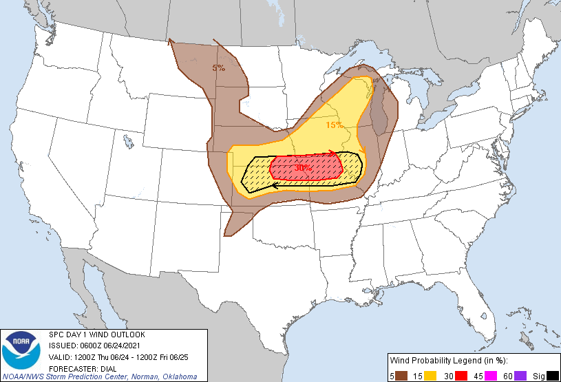
Probability of damaging thunderstorm winds or wind gusts of 50 knots or higher within 25 miles of a point. Hatched Area: 10% of greater probability of wind gusts 65 knots or greater within 25 miles of a point.
Day 1 Wind Risk
Area (sq. mi.)
Area Pop.
Some Larger Population Centers in Risk Area
SIG SEVERE
96,572
7,040,940
Kansas City, MO...St. Louis, MO...Overland Park, KS...Kansas City, KS...Topeka, KS...
30 %
45,731
3,254,448
Kansas City, MO...Overland Park, KS...Kansas City, KS...Topeka, KS...Olathe, KS...
SPC AC 240600
Day 1 Convective Outlook
NWS Storm Prediction Center Norman OK
0100 AM CDT Thu Jun 24 2021
Valid 241200Z - 251200Z
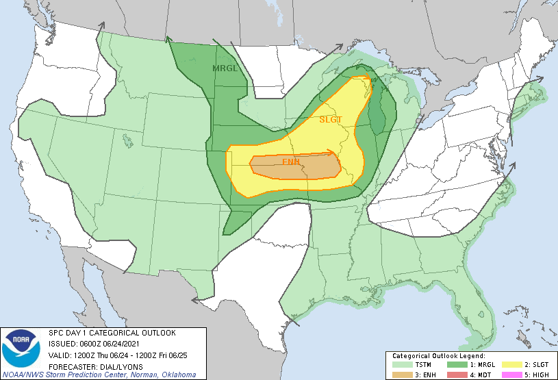
...THERE IS AN ENHANCED RISK OF SEVERE THUNDERSTORMS FROM A PORTION
OF THE CENTRAL PLAINS INTO THE MIDDLE MISSISSIPPI VALLEY REGION...
...SUMMARY...
Scattered strong to severe thunderstorms are expected across a broad
region of the central Plains, Mid Mississippi Valley, and the upper
Midwest on Thursday. The greatest threat including the potential for
significant wind damage is forecast over the central Plains into the
middle Mississippi Valley.
...Central Plains through middle Mississippi Valley...
MCS currently over eastern NE continue into northern MO through the
morning before weakening, likely posing an ongoing risk for damaging
wind. The remnant outflow boundary should extend from central MO
northwestward through northeast KS into eastern NE, and this feature
will shift northeast during the day. Robust boundary-layer recovery
and destabilization will likely occur in the vicinity of and west of
this boundary as rich low-level moisture (low 70s F dewpoints)
advects northeast along a southwesterly low-level jet. A cold front
will likely move slowly southeast and should extend from the upper
Midwest southwest through central and southwest NE, then northwest
into the central High Plains. South of this feature, easterly
low-level winds are expected north of a thermal low that will be
situated over western KS. A dryline should extend southward from the
thermal low into the southern High Plains. A corridor of richer
low-level moisture will likely persist with the easterly low-level
flow regime across northern KS into central and eastern NE. A warm
elevated mixed layer with 8.5+ C/km mid-level lapse rates will
persist across this region above the moist boundary layer
contributing to MLCAPE from 3000-4000 J/kg.
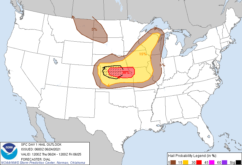
Potential areas for thunderstorm initiation include the deeply mixed
boundary layer across the central High Plains, along the dryline
from the TX Panhandle into southwest KS and along/north of the
outflow boundary across northeast KS into northwest MO and southeast
NE. High-based storms that develop over western KS and southwest NE
will likely intensify as they spread east and intercept the moist
and unstable boundary layer across southern NE into northern KS.
Vertical wind profiles with 40+ kt effective bulk shear will support
supercells as the initial storm mode, but storms should eventually
evolve into an organized MCS with potential for significant wind
damage as it continues through the central Plains into the middle MS
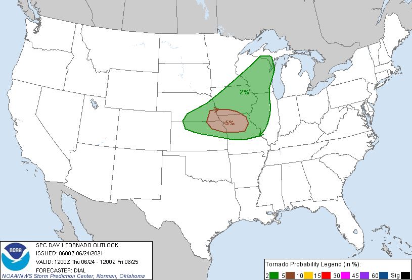
Valley during the afternoon and into the overnight. The best threat
for a few tornadoes will be along and just to the cool side of the
outflow boundary from northeast KS/northwest MO into southeast NE
and southwestern IA, where 0-1 km hodographs will be the most
supportive of low-level mesocyclones, especially with any discrete
supercells that can develop during the afternoon or early evening.
...Upper Midwest and Great Lakes region...
Thunderstorms are expected to develop along a cold front during the
afternoon within an environment characterized by modest instability
and 30-40 kt effective bulk shear. The stronger storms may produce a
few locally strong to severe wind gusts and hail from afternoon into
the early evening.
..Dial/Lyons.. 06/24/2021
CLICK TO GET WUUS01 PTSDY1 PRODUCT
NOTE: THE NEXT DAY 1 OUTLOOK IS SCHEDULED BY 1300Z