Oklahoma City, OK...Kansas City, MO...Omaha, NE...Overland Park, KS...Kansas City, KS...
2 %
79,653
3,377,358
Denton, TX...Sioux City, IA...Blue Springs, MO...Keller, TX...Sherman, TX...
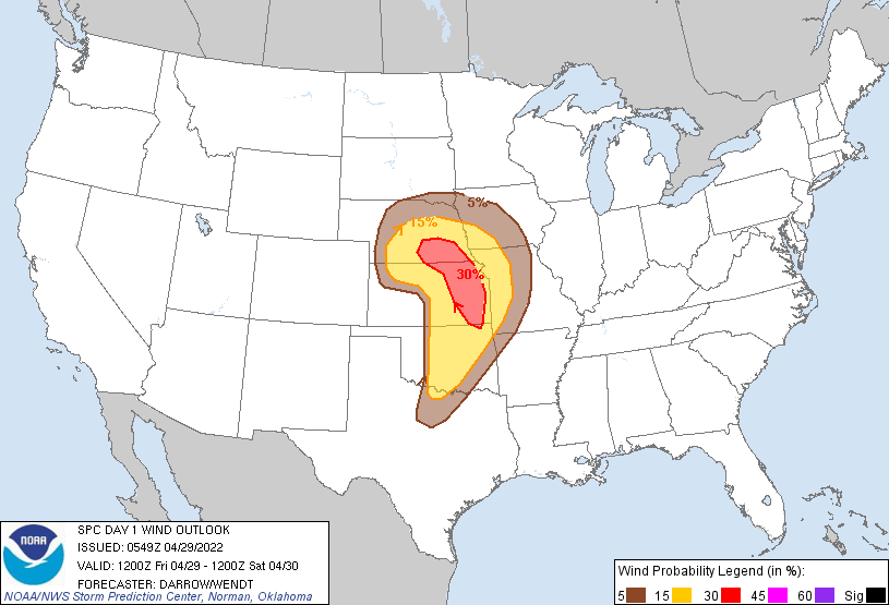
Probabilistic Damaging Wind Graphic
Probability of damaging thunderstorm winds or wind gusts of 50 knots or higher within 25 miles of a point. Hatched Area: 10% of greater probability of wind gusts 65 knots or greater within 25 miles of a point.
Day 1 Wind Risk
Area (sq. mi.)
Area Pop.
Some Larger Population Centers in Risk Area
30 %
31,703
1,252,316
Lincoln, NE...Topeka, KS...Lawrence, KS...Manhattan, KS...Grand Island, NE...
15 %
115,890
8,135,610
Oklahoma City, OK...Kansas City, MO...Omaha, NE...Tulsa, OK...Wichita, KS...
5 %
98,163
5,624,960
Fort Worth, TX...Des Moines, IA...Springfield, MO...Denton, TX...Lewisville, TX...
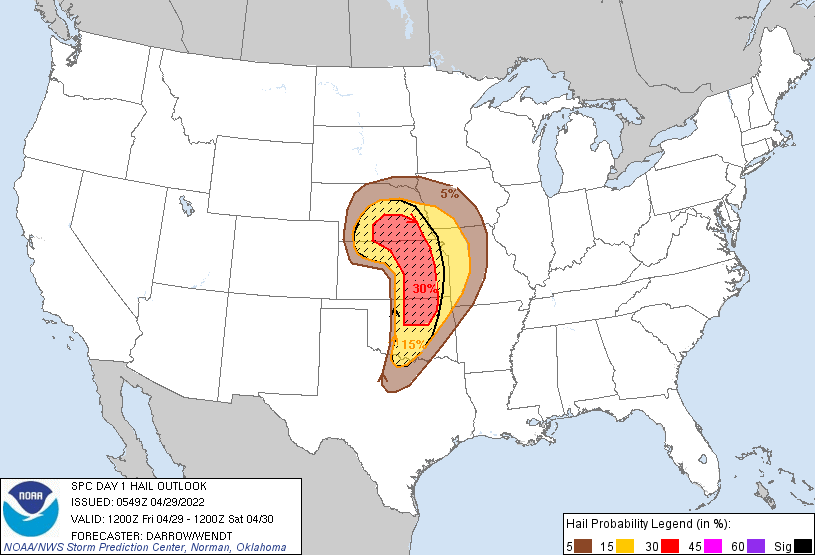
Probabilistic Large Hail Graphic
Probability of hail 1" or larger within 25 miles of a point. Hatched Area: 10% or greater probability of hail 2" or larger within 25 miles of a point.
Day 1 Hail Risk
Area (sq. mi.)
Area Pop.
Some Larger Population Centers in Risk Area
SIG SEVERE
110,099
5,525,698
Oklahoma City, OK...Tulsa, OK...Wichita, KS...Lincoln, NE...Topeka, KS...
Oklahoma City, OK...Kansas City, MO...Omaha, NE...Overland Park, KS...Kansas City, KS...
5 %
98,502
5,744,134
Fort Worth, TX...Des Moines, IA...Springfield, MO...Denton, TX...Lewisville, TX...
SPC AC 290549
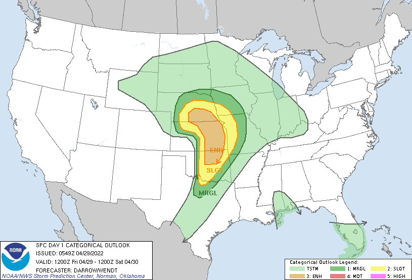
Day 1 Convective Outlook
NWS Storm Prediction Center Norman OK
1249 AM CDT Fri Apr 29 2022
Valid 291200Z - 301200Z
...THERE IS AN ENHANCED RISK OF SEVERE THUNDERSTORMS ACROSS PORTIONS
OF THE CENTRAL AND SOUTHERN PLAINS...
...SUMMARY...
Severe thunderstorms capable of all hazards are possible Friday
afternoon into Friday night across portions of the southern and
central Plains into the lower Missouri Valley. A few strong
tornadoes, very large hail, and damaging winds are possible.
...Central/Southern Plains...
Strong mid-level short-wave trough is currently digging
east-southeast across the northern Great Basin toward the central
Rockies. Latest model guidance suggest 70kt+ 500mb speed max will
translate across southern CO during the afternoon before ejecting
across KS into southeast NE by 06z. In response to this feature, lee
surface cyclone will track across northwest KS into northeast KS by
early evening. This evolution should encourage a well-defined
dryline to mix into central KS-western OK by peak heating, trailing
into northwest TX as post-dryline surface temperatures soar into the
90s.
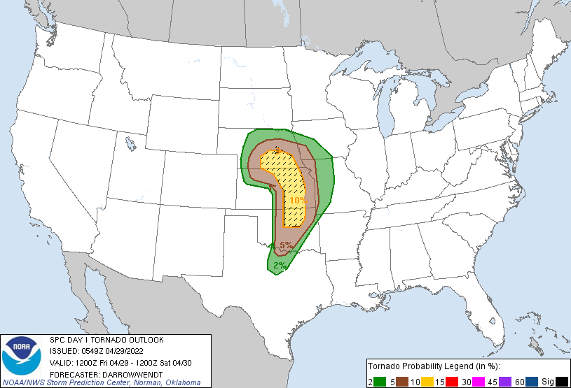
Early this morning, slow-moving MCS has propagated into southeast NE
with scattered convection trailing west, just north of the KS
border. This activity is expected to gradually wane/shift east by
daybreak. Stronger-forced convection is now responding to the short
wave over the NE Panhandle and this activity should gradually spread
east through late morning. Latest thinking is low-level moisture
should hold across southern NE, just north of the surface low as
easterly boundary-layer component in the wake of the ongoing MCS
will persist across this region. With upper 50s/lower 60s surface
dew points expected into portions of northwest KS, supercells should
readily develop ahead of the approaching short wave by early
afternoon. An expanding corridor of scattered supercells should
spread along the NE/KS border within a strongly sheared environment
characterized by MUCAPE in excess of 2000 J/kg. Forecast soundings
strongly suggest very large hail, in excess of 3 inches may be noted
within this steep lapse-rate environment. Additionally, a few
tornadoes appear likely with this activity, possibly even a strong
tornado.
Farther south along the dryline, intense surface heating should lead
to minimal CINH by 21z and isolated supercells are expected to
develop across KS into northern OK where mid-level height falls are
expected. Models continue to suggest low-mid 60s surface dew points
will be noted immediately ahead of the dryline which will result in
a narrow corridor of 3000 J/kg SBCAPE. While model guidance produces
minimal/no precipitation along the dryline south of I40 over OK into
TX, low-level convergence along the boundary may prove adequate for
sustained updrafts at lower latitudes. This portion of the outlook
is highly conditional, but if storms develop they will be severe
with very large hail (3-4 inch possible) along with a threat for
tornadoes.
While storms along the dryline will likely remain isolated through
early evening, additional convection should develop along the cold
front as it surges across eastern KS into northeast OK during the
overnight hours. Damaging winds may be more common with this more
organized frontal convection.
..Darrow/Wendt.. 04/29/2022
CLICK TO GET WUUS01 PTSDY1 PRODUCT
NOTE: THE NEXT DAY 1 OUTLOOK IS SCHEDULED BY 1300Z