Memphis, TN...Little Rock, AR...Abilene, TX...Wichita Falls, TX...North Little Rock, AR...
Probabilistic Damaging Wind Graphic
Probability of damaging thunderstorm winds or wind gusts of 50 knots or higher within 25 miles of a point. Hatched Area: 10% of greater probability of wind gusts 65 knots or greater within 25 miles of a point.
Day 1 Wind Risk
Area (sq. mi.)
Area Pop.
Some Larger Population Centers in Risk Area
SIG SEVERE
29,260
2,782,932
Oklahoma City, OK...Tulsa, OK...Broken Arrow, OK...Edmond, OK...Fayetteville, AR...
Dallas, TX...Austin, TX...Memphis, TN...Fort Worth, TX...Kansas City, MO...
SPC AC 021626
Day 1 Convective Outlook
NWS Storm Prediction Center Norman OK
1126 AM CDT Mon May 02 2022
Valid 021630Z - 031200Z
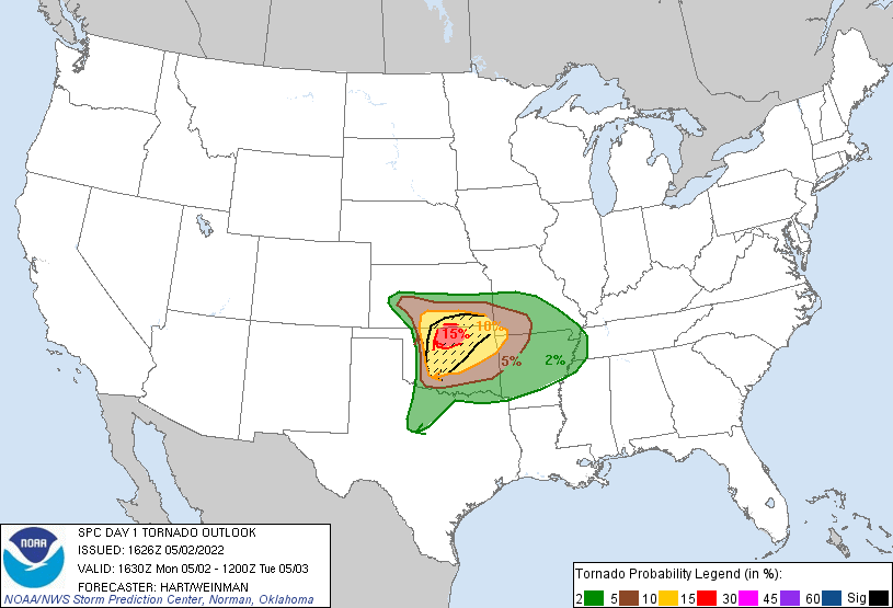
...THERE IS A MODERATE RISK OF SEVERE THUNDERSTORMS THIS AFTERNOON
AND EARLY EVENING OVER FAR SOUTHERN KANSAS AND NORTHERN OKLAHOMA...
...SUMMARY...
Intense severe thunderstorms are expected across portions of
northern Oklahoma and far southern Kansas, mainly between about 3 to
11 PM CDT. Tornadoes are likely, a few of which could be strong,
along with widespread damaging winds and very large hail.
...KS/OK...
Morning water vapor imagery shows a fast-moving compact upper trough
moving across the Rockies, with an associated 60+ knot mid-level
speed max tracking quickly into KS/OK. At the nose of this jet, a
rather deep surface low is over southwest KS. Strong southerly low
level winds are present in the warm sector of the low, but moisture
return is complicated by multiple clusters of remnant convection and
outflow boundaries. Rich moisture has returned to southern OK to
the south of the outflow boundaries, and is still expected to make a
rapid northward return this afternoon.
Present indications are that multiple convective scenarios will play
out in close areal/temporal proximity today over northwest OK.
Initial storms may be along the bent-back portion of the low-level
moisture plume over southwest KS. These storms will be in a very
favorable low-level shear environment for supercell structures and
possibly tornadoes, but early initiation (around 18z) may be before
sufficient low-level destabilization can fully occur. Nevertheless,
a few severe storms are expected in this regime that track
east-northeastward into south-central KS this afternoon and evening.
Just to the south and east of this setup, intense discrete
supercells are expected to form by mid-afternoon along the dryline
near or just south of the triple-point along the KS/OK border.
These storms will have the greatest risk of significant tornadoes
and very large hail, assuming they can persist ahead of the
approaching cold front. This threat area is depicted in the 15%
tornado risk area. Several CAM solutions suggest that convection
will attempt to form farther south along the dryline this afternoon,
but few are able to sustain this activity. While this risk of
thunderstorm development is lower than farther north, it is non-zero
and any storm that can mature would pose similar risks of
significant severe weather including tornadoes.
A strong cold front will surge into central OK by late afternoon,
undercutting existing storms and becoming a focus for the
development of a squall line. These storms will also pose a risk of
rather widespread damaging wind gusts, very large hail, and a few
tornadoes through the evening. Storms may persist well into the
night into the Red River valley.
..Hart/Weinman.. 05/02/2022
CLICK TO GET WUUS01 PTSDY1 PRODUCT
NOTE: THE NEXT DAY 1 OUTLOOK IS SCHEDULED BY 2000Z