Probability of damaging thunderstorm winds or wind gusts of 50 knots or higher within 25 miles of a point. Hatched Area: 10% of greater probability of wind gusts 65 knots or greater within 25 miles of a point.
Kansas City, MO...Overland Park, KS...Kansas City, KS...Cedar Rapids, IA...Olathe, KS...
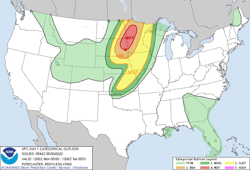
   SPC AC 300544

   Day 1 Convective Outlook
   NWS Storm Prediction Center Norman OK
   1244 AM CDT Mon May 30 2022

   Valid 301200Z - 311200Z

   ...THERE IS A MODERATE RISK OF SEVERE THUNDERSTORMS ACROSS PARTS OF
   EASTERN SOUTH DAKOTA...FAR SOUTHEAST NORTH DAKOTA AND WESTERN
   MINNESOTA...

   ...SUMMARY...
   Numerous severe thunderstorms are forecast across parts of the
   Northern Plains and Upper Mississippi Valley southward into the
   central Plains today into tonight. Large to giant hail, 60-80 mph
   gusts, and tornadoes are probable, including the possibility for a
   couple of intense long-track tornadoes.

   ...Outbreak of Severe Storms and Tornadoes Likely Today Across Parts
   of Northeast South Dakota, Far Southeast North Dakota and Western
   and Northern Minnesota...

   ...Northern Plains/Upper Mississippi Valley...
   An upper-level low, and an associated powerful 90 to 100 knot
   mid-level jet, will eject quickly north-northeastward across the
   central and northern Plains today. At the surface, a low will move
   northward across the eastern Dakotas. To the east of the surface low
   track, a moist and unstable airmass will be in place, with MLCAPE
   forecast to increase into the 2000 to 3000 J/kg range by late
   morning. As the exit region of the mid-level jet moves into the
   central Plains this morning, scattered convection is forecast to
   initiate in central Nebraska. These storms are expected to increase
   in coverage, moving north-northeastward into eastern South Dakota by
   early afternoon. A complex of storms is expected to quickly
   organize, moving north-northeastward across northeastern South
   Dakota, far southeast North Dakota into western and northern
   Minnesota. Severe storms and tornadoes appear likely with this
   convective system from this afternoon into the early evening.

   Several factors are coming together for an outbreak of severe storms
   today across parts of the northern Plains and upper Mississippi
   Valley. The first is that the system will be particularly organized,
   as the upper-level low rapidly deepens and the trough takes on a
   negative tilt. The second is that the exit region of the mid-level
   jet will be associated with a strong and focused band of large-scale
   ascent. The mid-level jet is forecast to move out of the base of the
   trough at nearly 50 knots, which will provide support for an
   outbreak. The third factor is that the mid-level and low-level jets
   will become coupled. This will strengthen lift and create strong
   deep-layer shear very favorable for severe storms. Intense
   supercells will be likely within a large convective cluster by
   afternoon.

   As the low-level jet consolidates in west-central Minnesota to the
   east of the upper-level low, shear in the boundary layer will become
   favorable for tornadoes. Tornadoes will be most likely from
   northeast South Dakota north-northeastward across western Minnesota.
   Forecast soundings along this corridor, to the west of the low-level
   jet, have 0-3 km storm-relative helicities in the 350 to 450 m2/s2
   range. This, along with curved hodographs, will contribute to a
   potential for a few strong tornadoes. One or two long-track
   tornadoes will be possible as well. Both strong deep-layer shear and
   steep mid-level lapse rates in the 7.5 to 8.0 C/km range, will be
   favorable for large hail. The more intense supercells will produce
   hailstones greater than 2 inches in diameter. The cluster of storms
   is expected to gradually organize into a bowing line segment by late
   afternoon, moving across northwest and north-central Minnesota,
   where a swath of wind gusts in the 60 to 70 knot range appears
   likely.

   ...Central Plains/Mid Missouri Valley...
   Mid-level flow will be southwesterly across the central Plains and
   Mid Missouri Valley today, in the wake of a strong upper-level
   system. At the surface, a dryline will sharpen during the day from
   far eastern Nebraska southward into central Kansas. To the east of
   the dryline, a moist and unstable airmass will be in place by
   afternoon, with surface dewpoints in the mid to upper 60s F. This
   will contribute to moderate instability. Thunderstorms are forecast
   to develop along or near the instability axis by late afternoon,
   with a rapid expansion of convective coverage taking place in the
   early to mid evening.

   Forecast soundings during the early evening from Wichita, Kansas
   northward to just east of Omaha have MLCAPE in the 2500 to 3000 J/kg
   range. This combined with 60 to 80 knots of 0-6 km shear will be
   favorable for supercells with large hail. Hailstones of greater than
   2 inches in diameter will be possible with the more intense
   supercells. Storms are expected to remain discrete for a few hours
   this evening. This combined with 0-3 km storm-relative helicities in
   the 200 to 250 m2/s2 range, will support a tornado threat. As a line
   emerges during the evening, a wind-damage threat will likely be
   maintained with the more intense cells or line segments. The severe
   threat should continue into tonight, as the line of strong to severe
   storms moves eastward across Iowa, northwestern Missouri and
   east-central Kansas.

   ..Broyles/Lyons.. 05/30/2022

   CLICK TO GET WUUS01 PTSDY1 PRODUCT

   NOTE: THE NEXT DAY 1 OUTLOOK IS SCHEDULED BY 1300Z