Oklahoma City, OK...Tulsa, OK...Wichita, KS...Norman, OK...Lawton, OK...
SLIGHT
110,901
3,069,582
Jackson, MS...Wichita Falls, TX...Monroe, LA...Salina, KS...Alexandria, LA...
MARGINAL
344,743
18,755,909
Fort Worth, TX...New Orleans, LA...Tampa, FL...St. Petersburg, FL...Baton Rouge, LA...
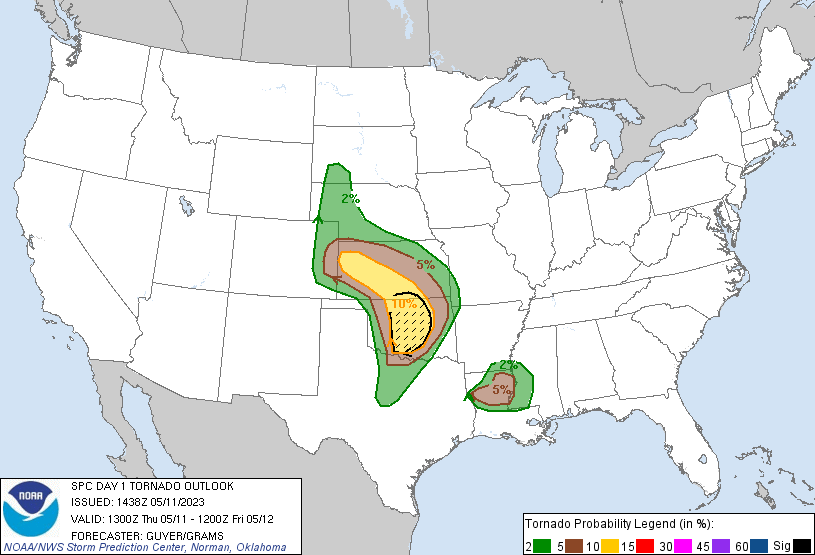
Probabilistic Tornado Graphic
Probability of a tornado within 25 miles of a point. Hatched Area: 10% or greater probability of EF2 - EF5 tornadoes within 25 miles of a point.
Day 1 Tornado Risk
Area (sq. mi.)
Area Pop.
Some Larger Population Centers in Risk Area
SIG SEVERE
25,277
2,055,060
Oklahoma City, OK...Norman, OK...Edmond, OK...Midwest City, OK...Moore, OK...
10 %
53,927
3,547,688
Oklahoma City, OK...Tulsa, OK...Wichita, KS...Norman, OK...Lawton, OK...
5 %
67,908
1,724,201
Wichita Falls, TX...Monroe, LA...Salina, KS...Alexandria, LA...Muskogee, OK...
2 %
121,711
4,840,959
Fort Worth, TX...Jackson, MS...Topeka, KS...Denton, TX...Lewisville, TX...
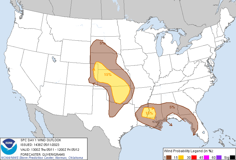
Probabilistic Damaging Wind Graphic
Probability of damaging thunderstorm winds or wind gusts of 50 knots or higher within 25 miles of a point. Hatched Area: 10% of greater probability of wind gusts 65 knots or greater within 25 miles of a point.
Day 1 Wind Risk
Area (sq. mi.)
Area Pop.
Some Larger Population Centers in Risk Area
15 %
124,906
5,574,760
Oklahoma City, OK...Tulsa, OK...Wichita, KS...Jackson, MS...Norman, OK...
5 %
308,172
19,000,467
Fort Worth, TX...New Orleans, LA...Tampa, FL...St. Petersburg, FL...Baton Rouge, LA...
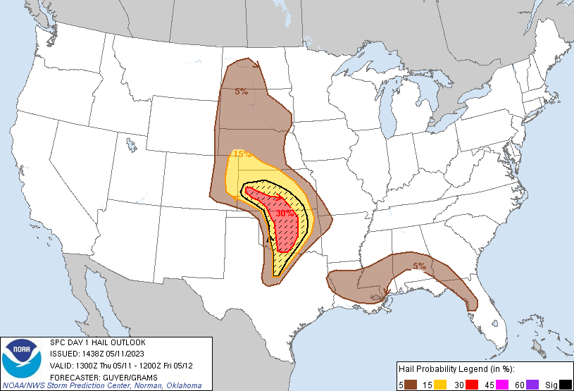
Probabilistic Large Hail Graphic
Probability of hail 1" or larger within 25 miles of a point. Hatched Area: 10% or greater probability of hail 2" or larger within 25 miles of a point.
Day 1 Hail Risk
Area (sq. mi.)
Area Pop.
Some Larger Population Centers in Risk Area
SIG SEVERE
77,799
4,250,755
Oklahoma City, OK...Tulsa, OK...Wichita, KS...Norman, OK...Wichita Falls, TX...
30 %
34,868
1,933,096
Oklahoma City, OK...Norman, OK...Lawton, OK...Edmond, OK...Midwest City, OK...
15 %
106,456
3,294,307
Tulsa, OK...Wichita, KS...Wichita Falls, TX...Broken Arrow, OK...Salina, KS...
5 %
309,151
13,307,332
Fort Worth, TX...New Orleans, LA...Baton Rouge, LA...Montgomery, AL...Columbus, GA...
SPC AC 111438
Day 1 Convective Outlook AMEND 1
NWS Storm Prediction Center Norman OK
0938 AM CDT Thu May 11 2023
Valid 111300Z - 121200Z
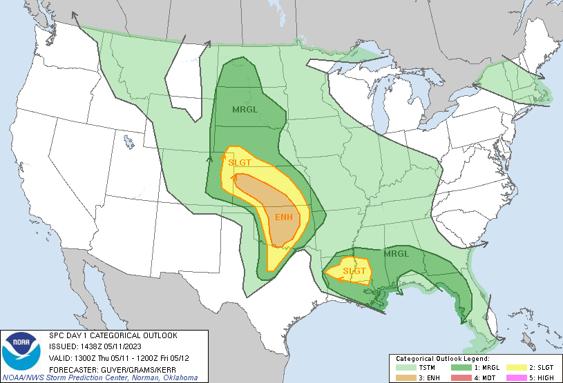
...THERE IS AN ENHANCED RISK OF SEVERE THUNDERSTORMS PARTS OF OK AND
KS...
...THERE IS A SLIGHT RISK OF SEVERE THUNDERSTORMS ACROSS THE LOWER
MS VALLEY...
AMENDED FOR LOWER MS VALLEY
...SUMMARY...
Scattered severe thunderstorms are expected this afternoon and
evening across parts of the Great Plains centered on Kansas and
Oklahoma. The greatest threat for at least a couple strong tornadic
supercells should exist across central Oklahoma between 5 to 9 PM
CDT. Isolated severe storms including a couple of tornadoes are
possible across the Lower Mississippi Valley.
...Central to southern Great Plains...
A pronounced mid-level low over the Raton Mesa will gradually weaken
as it drifts into the central High Plains through tonight. This
weakening trend will result in a moderate LLJ response this evening
into tonight with pockets of 30-45 kt 850-mb winds. Attendant
surface cyclone will still diurnally deepen as it similarly drifts
from the Raton Mesa into southwest KS today. The dryline will mix
into western OK and arc south-southwest into the Edwards Plateau. A
north/south-oriented inverted trough/quasi-stationary front will
extend north to the western Dakotas.
Dual corridors of thunderstorms are ongoing across a part of
southeast CO immediately north of the low and lingering farther
southeast near the northwest TX/southwest OK border. This latter
area is expected to diminish through midday, resulting in the
focused ascent region over southeast CO to spread east into western
KS. Low-topped supercells will become increasingly probable midday
to early afternoon within a marginally buoyant environment
initially. A smaller area of supercell development may also form in
the wake of this activity near the CO/KS border later in the
afternoon and yield a persistent severe threat into early evening.
A more volatile supercell environment should develop ahead of the
dryline in the western to central OK vicinity. A pronounced gradient
in MLCAPE is likely by late afternoon to early evening as the most
robust boundary-layer heating post-dryline occurs in TX, while a
plume of richer moisture advects north ahead of it. This should
support MLCAPE approaching 1500 J/kg near the OK/KS border to around
3500 J/kg along the Red River.
While a 500-mb jetlet over the southern High Plains will be in an
overall weakening state, its favorably timed eastward translation
across the dryline should support sustained supercells. Upper-level
wind fields will weaken with height and the bulk of hodograph
structure will consist of enlarged curvature from 0-3 km. This
suggests supercells should tend towards an HP character with a
slow-moving cluster type evolution, especially with southern extent
into north TX. Guidance has a bit more consistency with a moderate
increase in low-level flow this evening, supporting a strong tornado
threat with the most intense supercells over central OK. A small
MCS/embedded supercell cluster will probably persist into eastern OK
before eventually weakening overnight.
...Lower MS Valley vicinity -- Updated...
A low-amplitude convectively induced shortwave impulse over the
Ark-La-Tex will gradually shift east towards the TN Valley through
tonight. With stronger boundary-layer heating expected towards the
central Gulf Coast, increasingly broad convective development is
anticipated into the afternoon ahead of this impulse. Modest
deep-layer shear will likely prevail across much of the region.
Still, a few transient supercells and some multicell clustering will
offer a threat for a couple of mostly brief tornadoes, along with
sporadic damaging wind gusts and marginally severe hail into early
evening.
..Guyer.. 05/11/2023
CLICK TO GET WUUS01 PTSDY1 PRODUCT
NOTE: THE NEXT DAY 1 OUTLOOK IS SCHEDULED BY 1630Z