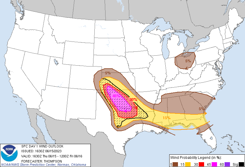
Probability of damaging thunderstorm winds or wind gusts of 50 knots or higher within 25 miles of a point. Hatched Area: 10% of greater probability of wind gusts 65 knots or greater within 25 miles of a point.
Day 1 Wind Risk
Area (sq. mi.)
Area Pop.
Some Larger Population Centers in Risk Area
SIG SEVERE
139,402
11,405,818
Dallas, TX...Fort Worth, TX...Oklahoma City, OK...Arlington, TX...Plano, TX...
45 %
39,082
2,153,926
Oklahoma City, OK...Norman, OK...Wichita Falls, TX...Lawton, OK...Edmond, OK...
SPC AC 151630
Day 1 Convective Outlook
NWS Storm Prediction Center Norman OK
1130 AM CDT Thu Jun 15 2023
Valid 151630Z - 161200Z
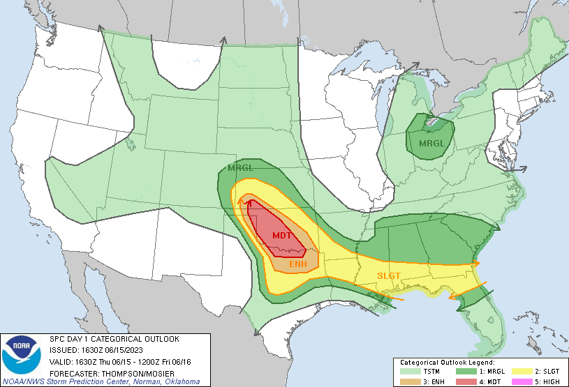
...THERE IS A MODERATE RISK OF SEVERE THUNDERSTORMS THIS AFTERNOON
INTO TONIGHT FROM WESTERN OK AND VICINITY INTO NORTH TX...
...SUMMARY...
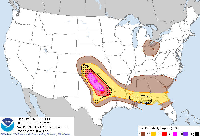
Widespread severe storms associated with giant hail (larger than 3-4
inches in diameter), intense wind damage (greater than 80 mph) and a
few tornadoes are expected from mid afternoon into tonight across
western and southern Oklahoma into north and northeast Texas.
...Southern Plains this afternoon through tonight...
A midlevel shortwave trough is moving east-northeastward across
northern NM as of late morning, and in response to this wave weak
lee cyclogenesis is underway across northeast NM/southeast CO. This
will help draw rich low-level moisture northwestward through the
afternoon, with mid-upper 60s boundary-layer dewpoints reaching
western OK/eastern TX Panhandle, and low-mid 70s farther southeast
into northwest and north TX. The moistening is occurring beneath
very steep midlevel lapse rates near 9 C/km, which will contribute
to extreme buoyancy (MLCAPE in excess of 4000 J/kg) this
afternoon/evening along the warm front and east of the dryline.
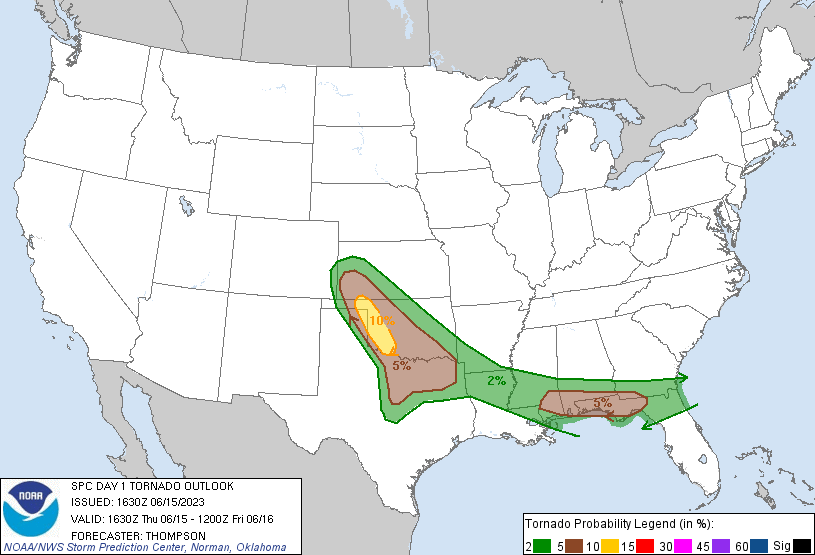
Severe storm development is expected by early-mid afternoon along
the dryline from the TX Panhandle into southwest KS, with subsequent
development on the dryline into northwest TX. The extreme buoyancy,
steep lapse rates and very long hodographs will all be quite
favorable for intense supercells capable of producing giant hail
(3-4 inches in diameter or greater). Despite modestly high
temperature-dewpoint spreads (20 to 25 F) initially, a gradual
increase in low-level shear/hodograph curvature will support some
tornado threat late this afternoon/evening.
As storms spread eastward this evening, upscale growth into one or
more clusters appears likely, with an increasing threat for swaths
of intense gusts in excess of 80 mph. The corridor of the most
intense storms is expected across western/southern and parts of
central OK, as well as north TX. Thus, the ENH/MDT risk areas have
been expanded southward and southeastward into TX to reflect both
the high-end hail threat with the initial supercells, and a high-end
wind threat with any late evening/overnight storm clusters.
...Southeast through this evening...
Clusters of severe storms are ongoing, along with a few supercells,
in a broken band along a residual/composite outflow boundary from
south GA to southern MS. An embedded mid-upper speed max is moving
east-southeastward over the lower MS Valley in concert with the
diurnal heating cycle, which will support continued storm
development along this corridor through this afternoon/evening.
Large CAPE and strong deep-layer vertical shear will favor large
hail (some of which could exceed 2 inches in diameter) and damaging
gusts (60-70 mph) as the primary severe threats. A couple of
tornadoes may also occur with supercells interacting with the
residual outflow boundary, primarily across southeast AL/southwest
GA/FL Panhandle.
...OH area this afternoon/evening...
An embedded shortwave trough is rotating southeastward over Lower
MI/Lake MI as of late morning, and the zone of ascent preceding this
trough will affect southeast Lower MI and northern OH later this
afternoon/evening. Some increase in midlevel flow and steepening of
low-level lapse rates will support thunderstorms capable of
producing strong outflow gusts, and perhaps marginally severe hail.
..Thompson/Mosier.. 06/15/2023
CLICK TO GET WUUS01 PTSDY1 PRODUCT
NOTE: THE NEXT DAY 1 OUTLOOK IS SCHEDULED BY 2000Z