|
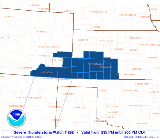
Initial List of Counties in SPC Severe Thunderstorm Watch 262 (WOU)
|
Back to Watch 262
|
 |
   WOUS64 KWNS 051933
   WOU2

   BULLETIN - IMMEDIATE BROADCAST REQUESTED
   SEVERE THUNDERSTORM WATCH OUTLINE UPDATE FOR WS 262
   NWS STORM PREDICTION CENTER NORMAN OK
   235 PM CDT MON MAY 5 2008

   SEVERE THUNDERSTORM WATCH 262 IS IN EFFECT UNTIL 900 PM CDT
   FOR THE FOLLOWING LOCATIONS

   COC009-061-071-099-060200-
   /O.NEW.KWNS.SV.A.0262.080505T1935Z-080506T0200Z/

   CO
   .    COLORADO COUNTIES INCLUDED ARE

   BACA                 KIOWA               LAS ANIMAS
   PROWERS


   KSC007-025-033-047-055-057-067-069-075-081-083-093-097-101-119-
   129-135-145-151-171-175-185-187-189-060200-
   /O.NEW.KWNS.SV.A.0262.080505T1935Z-080506T0200Z/

   KS
   .    KANSAS COUNTIES INCLUDED ARE

   BARBER               CLARK               COMANCHE
   EDWARDS              FINNEY              FORD
   GRANT                GRAY                HAMILTON
   HASKELL              HODGEMAN            KEARNY
   KIOWA                LANE                MEADE
   MORTON               NESS                PAWNEE
   PRATT                SCOTT               SEWARD
   STAFFORD             STANTON             STEVENS


   ATTN...WFO...PUB...DDC...
|
| Aviation Watch (SAW) for WW262 |
|---|
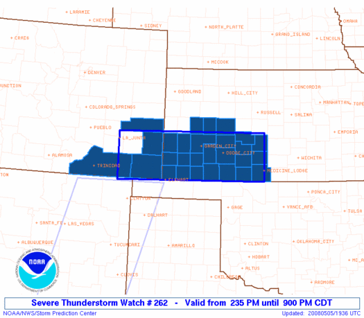 |
| Note:
The Aviation Watch (SAW) product is an approximation to the watch area.
The actual watch is depicted by the shaded areas. |
   SAW2
   WW 262 SEVERE TSTM CO KS 051935Z - 060200Z
   AXIS..45 STATUTE MILES NORTH AND SOUTH OF LINE..
   30S LHX/LA JUNTA CO/ - 25N P28/MEDICINE LODGE KS/
   ..AVIATION COORDS.. 40NM N/S /21N TBE - 48W ICT/
   HAIL SURFACE AND ALOFT..2 INCHES. WIND GUSTS..60 KNOTS.
   MAX TOPS TO 450. MEAN STORM MOTION VECTOR 27025.

   LAT...LON 38250351 38299858 37009858 36950351

   THIS IS AN APPROXIMATION TO THE WATCH AREA.  FOR A
   COMPLETE DEPICTION OF THE WATCH SEE WOUS64 KWNS
   FOR WOU2.
|
|


 @NWSSPC
