|
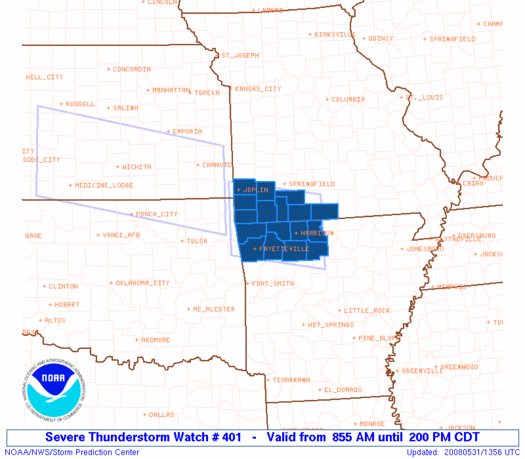
Initial List of Counties in SPC Severe Thunderstorm Watch 401 (WOU)
|
Back to Watch 401
|
 |
   WOUS64 KWNS 311349
   WOU1

   BULLETIN - IMMEDIATE BROADCAST REQUESTED
   SEVERE THUNDERSTORM WATCH OUTLINE UPDATE FOR WS 401
   NWS STORM PREDICTION CENTER NORMAN OK
   855 AM CDT SAT MAY 31 2008

   SEVERE THUNDERSTORM WATCH 401 IS IN EFFECT UNTIL 200 PM CDT
   FOR THE FOLLOWING LOCATIONS

   ARC007-009-015-087-089-101-129-143-311900-
   /O.NEW.KWNS.SV.A.0401.080531T1355Z-080531T1900Z/

   AR
   .    ARKANSAS COUNTIES INCLUDED ARE

   BENTON               BOONE               CARROLL
   MADISON              MARION              NEWTON
   SEARCY               WASHINGTON


   MOC009-043-097-109-119-145-153-209-213-311900-
   /O.NEW.KWNS.SV.A.0401.080531T1355Z-080531T1900Z/

   MO
   .    MISSOURI COUNTIES INCLUDED ARE

   BARRY                CHRISTIAN           JASPER
   LAWRENCE             MCDONALD            NEWTON
   OZARK                STONE               TANEY


   ATTN...WFO...TSA...SGF...LZK...
|
| Aviation Watch (SAW) for WW401 |
|---|
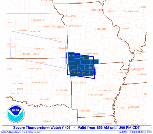 |
| Note:
The Aviation Watch (SAW) product is an approximation to the watch area.
The actual watch is depicted by the shaded areas. |
   SAW1
   WW 401 SEVERE TSTM AR MO 311355Z - 311900Z
   AXIS..50 STATUTE MILES NORTH AND SOUTH OF LINE..
   GMJ/GROVE OK/ - 35E HRO/HARRISON AR/
   ..AVIATION COORDS.. 45NM N/S /37NW RZC - 76SSE SGF/
   HAIL SURFACE AND ALOFT..2 INCHES. WIND GUSTS..60 KNOTS.
   MAX TOPS TO 500. MEAN STORM MOTION VECTOR 28040.

   LAT...LON 37339473 36999251 35549251 35889473

   THIS IS AN APPROXIMATION TO THE WATCH AREA.  FOR A
   COMPLETE DEPICTION OF THE WATCH SEE WOUS64 KWNS
   FOR WOU1.
|
|


 @NWSSPC
