|
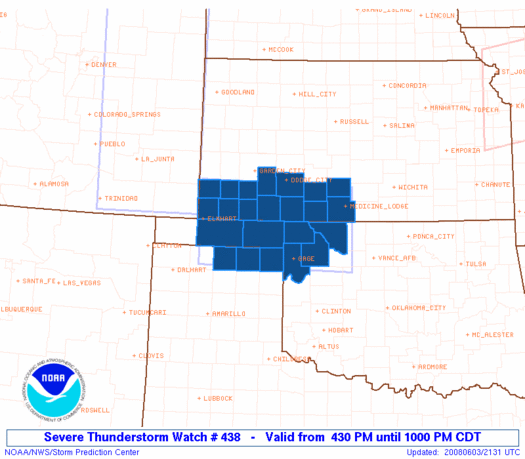
Initial List of Counties in SPC Severe Thunderstorm Watch 438 (WOU)
|
Back to Watch 438
|
 |
   WOUS64 KWNS 032128
   WOU8

   BULLETIN - IMMEDIATE BROADCAST REQUESTED
   SEVERE THUNDERSTORM WATCH OUTLINE UPDATE FOR WS 438
   NWS STORM PREDICTION CENTER NORMAN OK
   430 PM CDT TUE JUN 3 2008

   SEVERE THUNDERSTORM WATCH 438 IS IN EFFECT UNTIL 1000 PM CDT
   FOR THE FOLLOWING LOCATIONS

   KSC007-025-033-057-067-069-081-097-119-129-151-175-187-189-
   040300-
   /O.NEW.KWNS.SV.A.0438.080603T2130Z-080604T0300Z/

   KS
   .    KANSAS COUNTIES INCLUDED ARE

   BARBER               CLARK               COMANCHE
   FORD                 GRANT               GRAY
   HASKELL              KIOWA               MEADE
   MORTON               PRATT               SEWARD
   STANTON              STEVENS


   OKC007-045-059-139-151-153-040300-
   /O.NEW.KWNS.SV.A.0438.080603T2130Z-080604T0300Z/

   OK
   .    OKLAHOMA COUNTIES INCLUDED ARE

   BEAVER               ELLIS               HARPER
   TEXAS                WOODS               WOODWARD


   TXC195-295-357-040300-
   /O.NEW.KWNS.SV.A.0438.080603T2130Z-080604T0300Z/

   TX
   .    TEXAS COUNTIES INCLUDED ARE

   HANSFORD             LIPSCOMB            OCHILTREE


   ATTN...WFO...DDC...AMA...OUN...
|
| Aviation Watch (SAW) for WW438 |
|---|
 |
| Note:
The Aviation Watch (SAW) product is an approximation to the watch area.
The actual watch is depicted by the shaded areas. |
   SAW8
   WW 438 SEVERE TSTM KS OK TX 032130Z - 040300Z
   AXIS..55 STATUTE MILES NORTH AND SOUTH OF LINE..
   5SW EHA/ELKHART KS/ - 15ENE AVK/ALVA OK/
   ..AVIATION COORDS.. 50NM N/S /48W LBL - 39NW END/
   HAIL SURFACE AND ALOFT..2 INCHES. WIND GUSTS..60 KNOTS.
   MAX TOPS TO 500. MEAN STORM MOTION VECTOR 27020.

   LAT...LON 37740195 37659841 36069841 36150195

   THIS IS AN APPROXIMATION TO THE WATCH AREA.  FOR A
   COMPLETE DEPICTION OF THE WATCH SEE WOUS64 KWNS
   FOR WOU8.
|
|


 @NWSSPC
