|
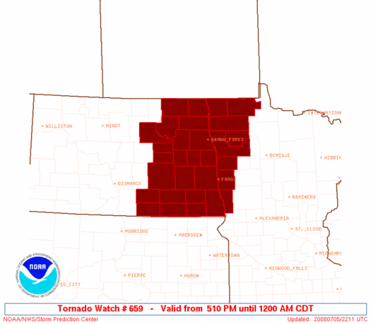
Initial List of Counties in SPC Tornado Watch 659 (WOU)
|
Back to Watch 659
|
 |
   WOUS64 KWNS 052208
   WOU9

   BULLETIN - IMMEDIATE BROADCAST REQUESTED
   TORNADO WATCH OUTLINE UPDATE FOR WT 659
   NWS STORM PREDICTION CENTER NORMAN OK
   510 PM CDT SAT JUL 5 2008

   TORNADO WATCH 659 IS IN EFFECT UNTIL 1200 AM CDT FOR THE
    FOLLOWING LOCATIONS

   MNC027-069-089-107-113-119-125-135-167-060500-
   /O.NEW.KWNS.TO.A.0659.080705T2210Z-080706T0500Z/

   MN
   .    MINNESOTA COUNTIES INCLUDED ARE

   CLAY                 KITTSON             MARSHALL
   NORMAN               PENNINGTON          POLK
   RED LAKE             ROSEAU              WILKIN


   NDC003-005-017-019-021-027-031-035-039-045-047-051-063-067-071-
   073-077-081-091-093-097-099-060500-
   /O.NEW.KWNS.TO.A.0659.080705T2210Z-080706T0500Z/

   ND
   .    NORTH DAKOTA COUNTIES INCLUDED ARE

   BARNES               BENSON              CASS
   CAVALIER             DICKEY              EDDY
   FOSTER               GRAND FORKS         GRIGGS
   LAMOURE              LOGAN               MCINTOSH
   NELSON               PEMBINA             RAMSEY
   RANSOM               RICHLAND            SARGENT
   STEELE               STUTSMAN            TRAILL
   WALSH


   ATTN...WFO...FGF...BIS...
|
| Aviation Watch (SAW) for WW659 |
|---|
 |
| Note:
The Aviation Watch (SAW) product is an approximation to the watch area.
The actual watch is depicted by the shaded areas. |
   SAW9
   WW 659 TORNADO MN ND 052210Z - 060500Z
   AXIS..75 STATUTE MILES EAST AND WEST OF LINE..
   20NW HCO/HALLOCK MN/ - 75SSE JMS/JAMESTOWN ND/
   ..AVIATION COORDS.. 65NM E/W /57S YWG - 33NNE ABR/
   HAIL SURFACE AND ALOFT..2 INCHES. WIND GUSTS..60 KNOTS.
   MAX TOPS TO 500. MEAN STORM MOTION VECTOR 27025.

   LAT...LON 48939559 45909651 45909963 48939890

   THIS IS AN APPROXIMATION TO THE WATCH AREA.  FOR A
   COMPLETE DEPICTION OF THE WATCH SEE WOUS64 KWNS
   FOR WOU9.
|
|


