|
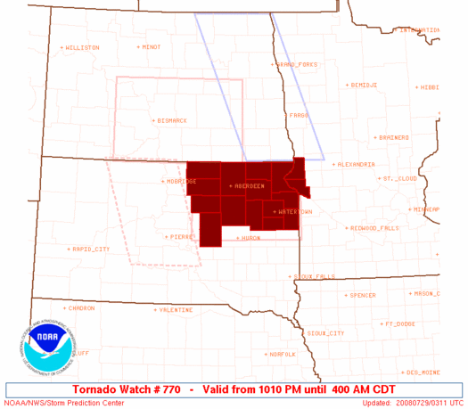
Initial List of Counties in SPC Tornado Watch 770 (WOU)
|
Back to Watch 770
|
 |
   WOUS64 KWNS 290308
   WOU0

   BULLETIN - IMMEDIATE BROADCAST REQUESTED
   TORNADO WATCH OUTLINE UPDATE FOR WT 770
   NWS STORM PREDICTION CENTER NORMAN OK
   1010 PM CDT MON JUL 28 2008

   TORNADO WATCH 770 IS IN EFFECT UNTIL 400 AM CDT FOR THE
    FOLLOWING LOCATIONS

   MNC011-155-290900-
   /O.NEW.KWNS.TO.A.0770.080729T0310Z-080729T0900Z/

   MN
   .    MINNESOTA COUNTIES INCLUDED ARE

   BIG STONE            TRAVERSE


   SDC013-025-029-037-039-045-049-051-057-059-089-091-109-115-
   290900-
   /O.NEW.KWNS.TO.A.0770.080729T0310Z-080729T0900Z/

   SD
   .    SOUTH DAKOTA COUNTIES INCLUDED ARE

   BROWN                CLARK               CODINGTON
   DAY                  DEUEL               EDMUNDS
   FAULK                GRANT               HAMLIN
   HAND                 MARSHALL            MCPHERSON
   ROBERTS              SPINK


   ATTN...WFO...ABR...
|
| Aviation Watch (SAW) for WW770 |
|---|
 |
| Note:
The Aviation Watch (SAW) product is an approximation to the watch area.
The actual watch is depicted by the shaded areas. |
   SAW0
   WW 770 TORNADO MN SD 290310Z - 290900Z
   AXIS..55 STATUTE MILES NORTH AND SOUTH OF LINE..
   60WSW ABR/ABERDEEN SD/ - 40ENE ATY/WATERTOWN SD/
   ..AVIATION COORDS.. 50NM N/S /50NNE PIR - 67NW RWF/
   HAIL SURFACE AND ALOFT..2.5 INCHES. WIND GUSTS..60 KNOTS.
   MAX TOPS TO 600. MEAN STORM MOTION VECTOR 32025.

   LAT...LON 45909955 45939638 44349638 44319955

   THIS IS AN APPROXIMATION TO THE WATCH AREA.  FOR A
   COMPLETE DEPICTION OF THE WATCH SEE WOUS64 KWNS
   FOR WOU0.
|
|


