|
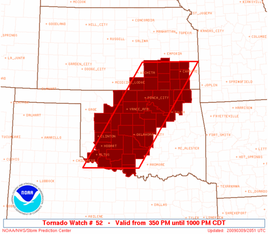
Initial List of Counties in SPC Tornado Watch 52 (WOU)
|
Back to Watch 52
|
 |
   WOUS64 KWNS 092047
   WOU2

   BULLETIN - IMMEDIATE BROADCAST REQUESTED
   TORNADO WATCH OUTLINE UPDATE FOR WT 52
   NWS STORM PREDICTION CENTER NORMAN OK
   350 PM CDT MON MAR 9 2009

   TORNADO WATCH 52 IS IN EFFECT UNTIL 1000 PM CDT FOR THE
    FOLLOWING LOCATIONS

   KSC001-015-019-035-049-073-099-125-133-191-205-207-100300-
   /O.NEW.KWNS.TO.A.0052.090309T2050Z-090310T0300Z/

   KS
   .    KANSAS COUNTIES INCLUDED ARE

   ALLEN                BUTLER              CHAUTAUQUA
   COWLEY               ELK                 GREENWOOD
   LABETTE              MONTGOMERY          NEOSHO
   SUMNER               WILSON              WOODSON


   OKC003-011-015-017-027-031-033-035-037-039-043-047-049-051-053-
   065-067-071-073-075-081-083-087-093-103-105-109-113-117-119-125-
   131-137-141-143-147-149-100300-
   /O.NEW.KWNS.TO.A.0052.090309T2050Z-090310T0300Z/

   OK
   .    OKLAHOMA COUNTIES INCLUDED ARE

   ALFALFA              BLAINE              CADDO
   CANADIAN             CLEVELAND           COMANCHE
   COTTON               CRAIG               CREEK
   CUSTER               DEWEY               GARFIELD
   GARVIN               GRADY               GRANT
   JACKSON              JEFFERSON           KAY
   KINGFISHER           KIOWA               LINCOLN
   LOGAN                MAJOR               MCCLAIN
   NOBLE                NOWATA              OKLAHOMA
   OSAGE                PAWNEE              PAYNE
   POTTAWATOMIE         ROGERS              STEPHENS
   TILLMAN              TULSA               WASHINGTON
   WASHITA


   ATTN...WFO...ICT...OUN...TSA...
|
| Aviation Watch (SAW) for WW52 |
|---|
 |
| Note:
The Aviation Watch (SAW) product is an approximation to the watch area.
The actual watch is depicted by the shaded areas. |
   SAW2
   WW 52 TORNADO KS OK 092050Z - 100300Z
   AXIS..70 STATUTE MILES EAST AND WEST OF LINE..
   35SSW FSI/FORT SILL OK/ - 35NW CNU/CHANUTE KS/
   ..AVIATION COORDS.. 60NM E/W /12N SPS - 63NNW OSW/
   HAIL SURFACE AND ALOFT..2 INCHES. WIND GUSTS..60 KNOTS.
   MAX TOPS TO 450. MEAN STORM MOTION VECTOR 25040.

   LAT...LON 34189986 38029722 38029465 34189741

   THIS IS AN APPROXIMATION TO THE WATCH AREA.  FOR A
   COMPLETE DEPICTION OF THE WATCH SEE WOUS64 KWNS
   FOR WOU2.
|
|


 @NWSSPC
