|
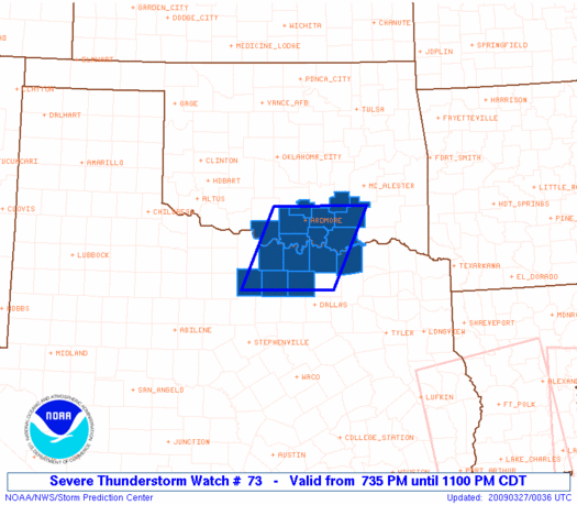
Initial List of Counties in SPC Severe Thunderstorm Watch 73 (WOU)
|
Back to Watch 73
|
 |
   WOUS64 KWNS 270029
   WOU3

   BULLETIN - IMMEDIATE BROADCAST REQUESTED
   SEVERE THUNDERSTORM WATCH OUTLINE UPDATE FOR WS 73
   NWS STORM PREDICTION CENTER NORMAN OK
   735 PM CDT THU MAR 26 2009

   SEVERE THUNDERSTORM WATCH 73 IS IN EFFECT UNTIL 1100 PM CDT
   FOR THE FOLLOWING LOCATIONS

   OKC005-013-019-029-067-069-085-095-099-270400-
   /O.NEW.KWNS.SV.A.0073.090327T0035Z-090327T0400Z/

   OK
   .    OKLAHOMA COUNTIES INCLUDED ARE

   ATOKA                BRYAN               CARTER
   COAL                 JEFFERSON           JOHNSTON
   LOVE                 MARSHALL            MURRAY


   TXC097-121-147-181-237-337-497-270400-
   /O.NEW.KWNS.SV.A.0073.090327T0035Z-090327T0400Z/

   TX
   .    TEXAS COUNTIES INCLUDED ARE

   COOKE                DENTON              FANNIN
   GRAYSON              JACK                MONTAGUE
   WISE


   ATTN...WFO...OUN...FWD...
|
| Aviation Watch (SAW) for WW73 |
|---|
 |
| Note:
The Aviation Watch (SAW) product is an approximation to the watch area.
The actual watch is depicted by the shaded areas. |
   SAW3
   WW 73 SEVERE TSTM OK TX 270035Z - 270400Z
   AXIS..55 STATUTE MILES EAST AND WEST OF LINE..
   25NE ADM/ARDMORE OK/ - 60SW GYI/SHERMAN TX/
   ..AVIATION COORDS.. 50NM E/W /30NE ADM - 23NW DFW/
   HAIL SURFACE AND ALOFT..2 INCHES. WIND GUSTS..60 KNOTS.
   MAX TOPS TO 450. MEAN STORM MOTION VECTOR 27035.

   LAT...LON 34549573 33099644 33099834 34549768

   THIS IS AN APPROXIMATION TO THE WATCH AREA.  FOR A
   COMPLETE DEPICTION OF THE WATCH SEE WOUS64 KWNS
   FOR WOU3.
|
|


 @NWSSPC
