|
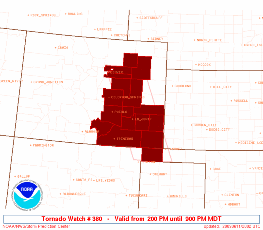
Initial List of Counties in SPC Tornado Watch 380 (WOU)
|
Back to Watch 380
|
 |
   WOUS64 KWNS 111956
   WOU0

   BULLETIN - IMMEDIATE BROADCAST REQUESTED
   TORNADO WATCH OUTLINE UPDATE FOR WT 380
   NWS STORM PREDICTION CENTER NORMAN OK
   200 PM MDT THU JUN 11 2009

   TORNADO WATCH 380 IS IN EFFECT UNTIL 900 PM MDT FOR THE
    FOLLOWING LOCATIONS

   COC001-005-009-011-025-039-041-055-061-071-073-087-089-099-101-
   121-120300-
   /O.NEW.KWNS.TO.A.0380.090611T2000Z-090612T0300Z/

   CO
   .    COLORADO COUNTIES INCLUDED ARE

   ADAMS                ARAPAHOE            BACA
   BENT                 CROWLEY             ELBERT
   EL PASO              HUERFANO            KIOWA
   LAS ANIMAS           LINCOLN             MORGAN
   OTERO                PROWERS             PUEBLO
   WASHINGTON


   OKC025-120300-
   /O.NEW.KWNS.TO.A.0380.090611T2000Z-090612T0300Z/

   OK
   .    OKLAHOMA COUNTIES INCLUDED ARE

   CIMARRON


   ATTN...WFO...BOU...AMA...PUB...
|
| Aviation Watch (SAW) for WW380 |
|---|
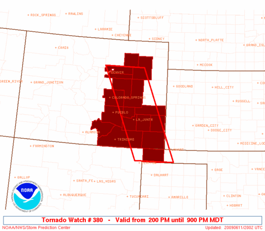 |
| Note:
The Aviation Watch (SAW) product is an approximation to the watch area.
The actual watch is depicted by the shaded areas. |
   SAW0
   WW 380 TORNADO CO OK 112000Z - 120300Z
   AXIS..50 STATUTE MILES EAST AND WEST OF LINE..
   45ENE DEN/DENVER CO/ - 45SW EHA/ELKHART KS/
   ..AVIATION COORDS.. 45NM E/W /29ENE DEN - 70SE TBE/
   HAIL SURFACE AND ALOFT..2 INCHES. WIND GUSTS..60 KNOTS.
   MAX TOPS TO 450. MEAN STORM MOTION VECTOR 28020.

   LAT...LON 40000315 36520156 36520337 40000504

   THIS IS AN APPROXIMATION TO THE WATCH AREA.  FOR A
   COMPLETE DEPICTION OF THE WATCH SEE WOUS64 KWNS
   FOR WOU0.
|
|


 @NWSSPC
