|
Initial List of Counties in SPC Severe Thunderstorm Watch 468 (WOU)
|
Back to Watch 468
|
 |
WOUS64 KWNS 182112
WOU8
BULLETIN - IMMEDIATE BROADCAST REQUESTED
SEVERE THUNDERSTORM WATCH OUTLINE UPDATE FOR WS 468
NWS STORM PREDICTION CENTER NORMAN OK
415 PM CDT THU JUN 18 2009
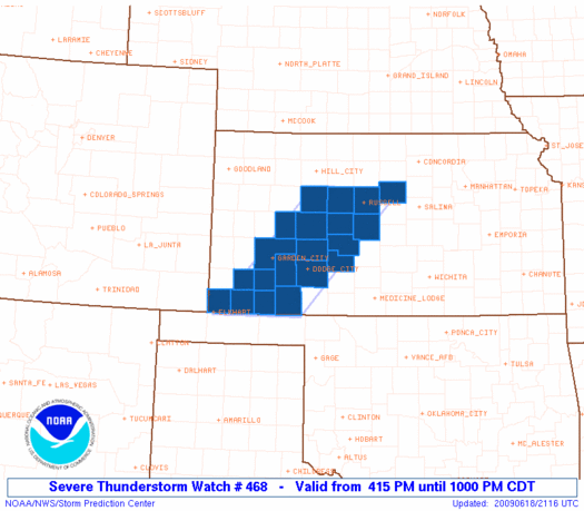
SEVERE THUNDERSTORM WATCH 468 IS IN EFFECT UNTIL 1000 PM CDT
FOR THE FOLLOWING LOCATIONS
KSC009-047-051-055-057-067-069-081-083-101-105-119-129-135-145-
165-167-175-189-195-190300-
/O.NEW.KWNS.SV.A.0468.090618T2115Z-090619T0300Z/
KS
. KANSAS COUNTIES INCLUDED ARE
BARTON EDWARDS ELLIS
FINNEY FORD GRANT
GRAY HASKELL HODGEMAN
LANE LINCOLN MEADE
MORTON NESS PAWNEE
RUSH RUSSELL SEWARD
STEVENS TREGO
ATTN...WFO...ICT...DDC...
|
| Aviation Watch (SAW) for WW468 |
|---|
 |
| Note:
The Aviation Watch (SAW) product is an approximation to the watch area.
The actual watch is depicted by the shaded areas. |
   SAW8
   WW 468 SEVERE TSTM KS 182115Z - 190300Z
   AXIS..50 STATUTE MILES EAST AND WEST OF LINE..
   5SSW LBL/LIBERAL KS/ - 20NNW RSL/RUSSELL KS/
   ..AVIATION COORDS.. 45NM E/W /4SSW LBL - 60E HLC/
   HAIL SURFACE AND ALOFT..2 INCHES. WIND GUSTS..60 KNOTS.
   MAX TOPS TO 550. MEAN STORM MOTION VECTOR 23025.

   LAT...LON 36970191 39119990 39119802 36970009

   THIS IS AN APPROXIMATION TO THE WATCH AREA.  FOR A
   COMPLETE DEPICTION OF THE WATCH SEE WOUS64 KWNS
   FOR WOU8.
|
|


 @NWSSPC
