|
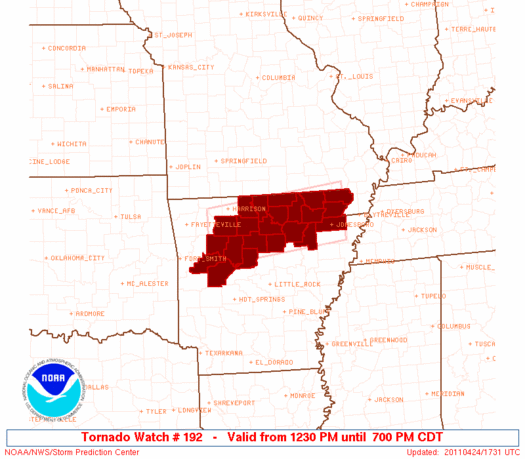
Initial List of Counties in SPC Tornado Watch 192 (WOU)
|
Back to Watch 192
|
 |
   WOUS64 KWNS 241724
   WOU2

   BULLETIN - IMMEDIATE BROADCAST REQUESTED
   TORNADO WATCH OUTLINE UPDATE FOR WT 192
   NWS STORM PREDICTION CENTER NORMAN OK
   1230 PM CDT SUN APR 24 2011

   TORNADO WATCH 192 IS IN EFFECT UNTIL 700 PM CDT FOR THE
    FOLLOWING LOCATIONS

   ARC005-021-023-029-031-049-055-063-065-067-071-075-083-089-101-
   115-121-129-135-137-141-149-250000-
   /O.NEW.KWNS.TO.A.0192.110424T1730Z-110425T0000Z/

   AR
   .    ARKANSAS COUNTIES INCLUDED ARE

   BAXTER               CLAY                CLEBURNE
   CONWAY               CRAIGHEAD           FULTON
   GREENE               INDEPENDENCE        IZARD
   JACKSON              JOHNSON             LAWRENCE
   LOGAN                MARION              NEWTON
   POPE                 RANDOLPH            SEARCY
   SHARP                STONE               VAN BUREN
   YELL


   ATTN...WFO...LZK...MEG...
|
| Aviation Watch (SAW) for WW192 |
|---|
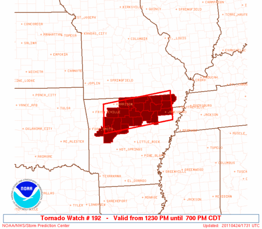 |
| Note:
The Aviation Watch (SAW) product is an approximation to the watch area.
The actual watch is depicted by the shaded areas. |
   SAW2
   WW 192 TORNADO AR 241730Z - 250000Z
   AXIS..40 STATUTE MILES NORTH AND SOUTH OF LINE..
   45NW RUE/RUSSELLVILLE AR/ - 25NE JBR/JONESBORO AR/
   ..AVIATION COORDS.. 35NM N/S /36ENE FSM - 30E ARG/
   HAIL SURFACE AND ALOFT..2 INCHES. WIND GUSTS..60 KNOTS.
   MAX TOPS TO 500. MEAN STORM MOTION VECTOR 26030.

   LAT...LON 36299366 36659033 35509033 35139366

   THIS IS AN APPROXIMATION TO THE WATCH AREA.  FOR A
   COMPLETE DEPICTION OF THE WATCH SEE WOUS64 KWNS
   FOR WOU2.
|
|


 @NWSSPC
