|
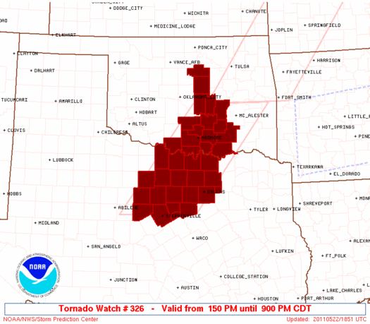
Initial List of Counties in SPC Tornado Watch 326 (WOU)
|
Back to Watch 326
|
 |
   WOUS64 KWNS 221844
   WOU6

   BULLETIN - IMMEDIATE BROADCAST REQUESTED
   TORNADO WATCH OUTLINE UPDATE FOR WT 326
   NWS STORM PREDICTION CENTER NORMAN OK
   150 PM CDT SUN MAY 22 2011

   TORNADO WATCH 326 IS IN EFFECT UNTIL 900 PM CDT FOR THE
    FOLLOWING LOCATIONS

   OKC005-013-019-029-049-063-067-069-081-085-095-099-119-123-125-
   133-230200-
   /O.NEW.KWNS.TO.A.0326.110522T1850Z-110523T0200Z/

   OK
   .    OKLAHOMA COUNTIES INCLUDED ARE

   ATOKA                BRYAN               CARTER
   COAL                 GARVIN              HUGHES
   JEFFERSON            JOHNSTON            LINCOLN
   LOVE                 MARSHALL            MURRAY
   PAYNE                PONTOTOC            POTTAWATOMIE
   SEMINOLE


   TXC077-085-097-113-121-133-143-181-221-237-251-337-363-367-397-
   425-429-439-497-503-230200-
   /O.NEW.KWNS.TO.A.0326.110522T1850Z-110523T0200Z/

   TX
   .    TEXAS COUNTIES INCLUDED ARE

   CLAY                 COLLIN              COOKE
   DALLAS               DENTON              EASTLAND
   ERATH                GRAYSON             HOOD
   JACK                 JOHNSON             MONTAGUE
   PALO PINTO           PARKER              ROCKWALL
   SOMERVELL            STEPHENS            TARRANT
   WISE                 YOUNG


   ATTN...WFO...OUN...FWD...
|
| Aviation Watch (SAW) for WW326 |
|---|
 |
| Note:
The Aviation Watch (SAW) product is an approximation to the watch area.
The actual watch is depicted by the shaded areas. |
   SAW6
   WW 326 TORNADO OK TX 221850Z - 230200Z
   AXIS..70 STATUTE MILES EAST AND WEST OF LINE..
   25NNW MLC/MCALESTER OK/ - 40SSW MWL/MINERAL WELLS TX/
   ..AVIATION COORDS.. 60NM E/W /23NNW MLC - 65WNW ACT/
   HAIL SURFACE AND ALOFT..4 INCHES. WIND GUSTS..60 KNOTS.
   MAX TOPS TO 500. MEAN STORM MOTION VECTOR 27020.

   LAT...LON 35209470 32249712 32249952 35209719

   THIS IS AN APPROXIMATION TO THE WATCH AREA.  FOR A
   COMPLETE DEPICTION OF THE WATCH SEE WOUS64 KWNS
   FOR WOU6.
|
|


 @NWSSPC
