|
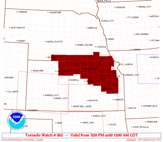
Initial List of Counties in SPC Tornado Watch 362 (WOU)
|
Back to Watch 362
|
 |
   WOUS64 KWNS 242216
   WOU2

   BULLETIN - IMMEDIATE BROADCAST REQUESTED
   TORNADO WATCH OUTLINE UPDATE FOR WT 362
   NWS STORM PREDICTION CENTER NORMAN OK
   520 PM CDT TUE MAY 24 2011

   TORNADO WATCH 362 IS IN EFFECT UNTIL 1200 AM CDT FOR THE
    FOLLOWING LOCATIONS

   KSC003-013-027-029-031-041-045-059-061-085-087-089-111-117-123-
   127-131-139-141-143-147-149-157-161-163-177-183-197-201-
   250500-
   /O.NEW.KWNS.TO.A.0362.110524T2220Z-110525T0500Z/

   KS
   .    KANSAS COUNTIES INCLUDED ARE

   ANDERSON             BROWN               CLAY
   CLOUD                COFFEY              DICKINSON
   DOUGLAS              FRANKLIN            GEARY
   JACKSON              JEFFERSON           JEWELL
   LYON                 MARSHALL            MITCHELL
   MORRIS               NEMAHA              OSAGE
   OSBORNE              OTTAWA              PHILLIPS
   POTTAWATOMIE         REPUBLIC            RILEY
   ROOKS                SHAWNEE             SMITH
   WABAUNSEE            WASHINGTON


   NEC061-065-067-083-095-129-133-147-169-181-250500-
   /O.NEW.KWNS.TO.A.0362.110524T2220Z-110525T0500Z/

   NE
   .    NEBRASKA COUNTIES INCLUDED ARE

   FRANKLIN             FURNAS              GAGE
   HARLAN               JEFFERSON           NUCKOLLS
   PAWNEE               RICHARDSON          THAYER
   WEBSTER


   ATTN...WFO...TOP...GID...OAX...
|
| Aviation Watch (SAW) for WW362 |
|---|
 |
| Note:
The Aviation Watch (SAW) product is an approximation to the watch area.
The actual watch is depicted by the shaded areas. |
   SAW2
   WW 362 TORNADO KS NE 242220Z - 250500Z
   AXIS..60 STATUTE MILES NORTH AND SOUTH OF LINE..
   60NW RSL/RUSSELL KS/ - 30NNE TOP/TOPEKA KS/
   ..AVIATION COORDS.. 50NM N/S /31ENE HLC - 40WNW MKC/
   HAIL SURFACE AND ALOFT..2 INCHES. WIND GUSTS..60 KNOTS.
   MAX TOPS TO 500. MEAN STORM MOTION VECTOR 22035.

   LAT...LON 40349962 40349540 38599540 38599962

   THIS IS AN APPROXIMATION TO THE WATCH AREA.  FOR A
   COMPLETE DEPICTION OF THE WATCH SEE WOUS64 KWNS
   FOR WOU2.
|
|


 @NWSSPC
