|
Initial List of Counties in SPC Severe Thunderstorm Watch 391 (WOU)
|
Back to Watch 391
|
 |
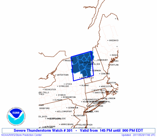
   WOUS64 KWNS 281739
   WOU1

   BULLETIN - IMMEDIATE BROADCAST REQUESTED
   SEVERE THUNDERSTORM WATCH OUTLINE UPDATE FOR WS 391
   NWS STORM PREDICTION CENTER NORMAN OK
   145 PM EDT SAT MAY 28 2011

   SEVERE THUNDERSTORM WATCH 391 IS IN EFFECT UNTIL 900 PM EDT
   FOR THE FOLLOWING LOCATIONS

   NYC019-031-290100-
   /O.NEW.KWNS.SV.A.0391.110528T1745Z-110529T0100Z/

   NY
   .    NEW YORK COUNTIES INCLUDED ARE

   CLINTON              ESSEX


   VTC001-005-007-009-011-013-015-017-019-021-023-027-290100-
   /O.NEW.KWNS.SV.A.0391.110528T1745Z-110529T0100Z/

   VT
   .    VERMONT COUNTIES INCLUDED ARE

   ADDISON              CALEDONIA           CHITTENDEN
   ESSEX                FRANKLIN            GRAND ISLE
   LAMOILLE             ORANGE              ORLEANS
   RUTLAND              WASHINGTON          WINDSOR


   ATTN...WFO...BTV...
|
| Aviation Watch (SAW) for WW391 |
|---|
 |
| Note:
The Aviation Watch (SAW) product is an approximation to the watch area.
The actual watch is depicted by the shaded areas. |
   SAW1
   WW 391 SEVERE TSTM NY VT 281745Z - 290100Z
   AXIS..55 STATUTE MILES EAST AND WEST OF LINE..
   30WNW EFK/NEWPORT VT/ - 20ESE GFL/GLENS FALLS NY/
   ..AVIATION COORDS.. 50NM E/W /38NE PLB - 37NE ALB/
   HAIL SURFACE AND ALOFT..2 INCHES. WIND GUSTS..60 KNOTS.
   MAX TOPS TO 500. MEAN STORM MOTION VECTOR 23030.

   LAT...LON 45067166 43207216 43207434 45067391

   THIS IS AN APPROXIMATION TO THE WATCH AREA.  FOR A
   COMPLETE DEPICTION OF THE WATCH SEE WOUS64 KWNS
   FOR WOU1.
|
|


 @NWSSPC
