|
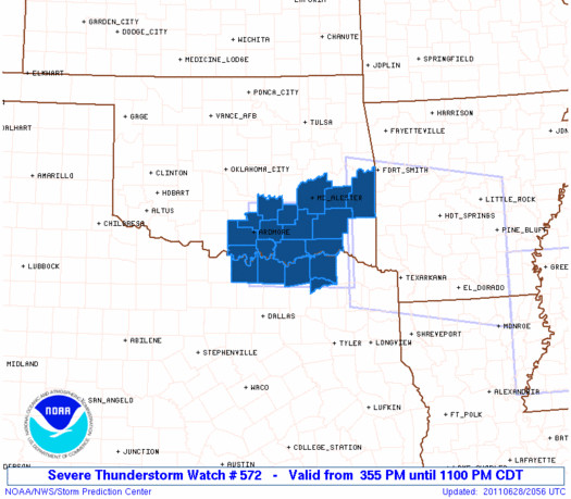
Initial List of Counties in SPC Severe Thunderstorm Watch 572 (WOU)
|
Back to Watch 572
|
 |
   WOUS64 KWNS 282051
   WOU2

   BULLETIN - IMMEDIATE BROADCAST REQUESTED
   SEVERE THUNDERSTORM WATCH OUTLINE UPDATE FOR WS 572
   NWS STORM PREDICTION CENTER NORMAN OK
   355 PM CDT TUE JUN 28 2011

   SEVERE THUNDERSTORM WATCH 572 IS IN EFFECT UNTIL 1100 PM CDT
   FOR THE FOLLOWING LOCATIONS

   OKC005-013-019-023-029-069-077-079-085-095-099-121-123-127-
   290400-
   /O.NEW.KWNS.SV.A.0572.110628T2055Z-110629T0400Z/

   OK
   .    OKLAHOMA COUNTIES INCLUDED ARE

   ATOKA                BRYAN               CARTER
   CHOCTAW              COAL                JOHNSTON
   LATIMER              LE FLORE            LOVE
   MARSHALL             MURRAY              PITTSBURG
   PONTOTOC             PUSHMATAHA


   TXC097-119-147-181-277-290400-
   /O.NEW.KWNS.SV.A.0572.110628T2055Z-110629T0400Z/

   TX
   .    TEXAS COUNTIES INCLUDED ARE

   COOKE                DELTA               FANNIN
   GRAYSON              LAMAR


   ATTN...WFO...OUN...FWD...TSA...
|
| Aviation Watch (SAW) for WW572 |
|---|
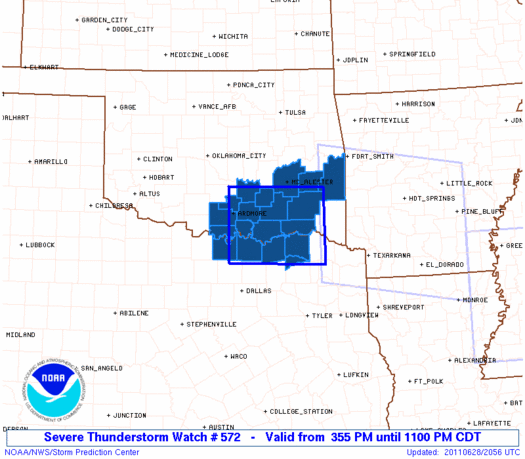 |
| Note:
The Aviation Watch (SAW) product is an approximation to the watch area.
The actual watch is depicted by the shaded areas. |
   SAW2
   WW 572 SEVERE TSTM OK TX 282055Z - 290400Z
   AXIS..50 STATUTE MILES NORTH AND SOUTH OF LINE..
   40NE PRX/PARIS TX/ - 15SSW ADM/ARDMORE OK/
   ..AVIATION COORDS.. 45NM N/S /54NW TXK - 8SSE ADM/
   HAIL SURFACE AND ALOFT..2.5 INCHES. WIND GUSTS..60 KNOTS.
   MAX TOPS TO 500. MEAN STORM MOTION VECTOR 35010.

   LAT...LON 33319495 33369712 34819712 34759495

   THIS IS AN APPROXIMATION TO THE WATCH AREA.  FOR A
   COMPLETE DEPICTION OF THE WATCH SEE WOUS64 KWNS
   FOR WOU2.
|
|


 @NWSSPC
