|
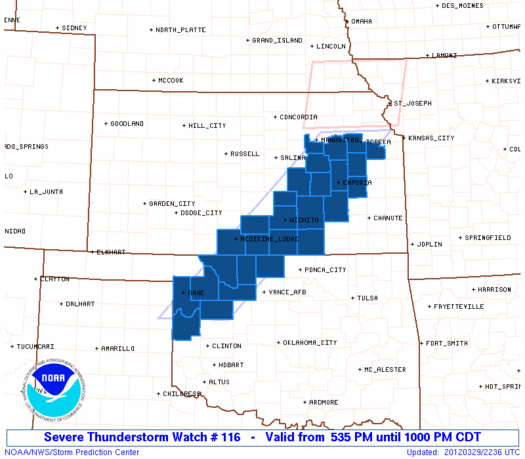
Initial List of Counties in SPC Severe Thunderstorm Watch 116 (WOU)
|
Back to Watch 116
|
 |
   WOUS64 KWNS 292229
   WOU6

   BULLETIN - IMMEDIATE BROADCAST REQUESTED
   SEVERE THUNDERSTORM WATCH OUTLINE UPDATE FOR WS 116
   NWS STORM PREDICTION CENTER NORMAN OK
   535 PM CDT THU MAR 29 2012

   SEVERE THUNDERSTORM WATCH 116 IS IN EFFECT UNTIL 1000 PM CDT
   FOR THE FOLLOWING LOCATIONS

   KSC007-015-017-031-035-045-061-073-077-079-095-111-115-127-139-
   173-177-191-197-300300-
   /O.NEW.KWNS.SV.A.0116.120329T2235Z-120330T0300Z/

   KS
   .    KANSAS COUNTIES INCLUDED ARE

   BARBER               BUTLER              CHASE
   COFFEY               COWLEY              DOUGLAS
   GEARY                GREENWOOD           HARPER
   HARVEY               KINGMAN             LYON
   MARION               MORRIS              OSAGE
   SEDGWICK             SHAWNEE             SUMNER
   WABAUNSEE


   OKC003-043-045-053-093-129-151-153-300300-
   /O.NEW.KWNS.SV.A.0116.120329T2235Z-120330T0300Z/

   OK
   .    OKLAHOMA COUNTIES INCLUDED ARE

   ALFALFA              DEWEY               ELLIS
   GRANT                MAJOR               ROGER MILLS
   WOODS                WOODWARD


   ATTN...WFO...DDC...OUN...TOP...ICT...
|
| Aviation Watch (SAW) for WW116 |
|---|
 |
| Note:
The Aviation Watch (SAW) product is an approximation to the watch area.
The actual watch is depicted by the shaded areas. |
   SAW6
   WW 116 SEVERE TSTM KS OK 292235Z - 300300Z
   AXIS..45 STATUTE MILES EAST AND WEST OF LINE..
   15NNW TOP/TOPEKA KS/ - 35SSE GAG/GAGE OK/
   ..AVIATION COORDS.. 40NM E/W /53W MKC - 35SSE GAG/
   HAIL SURFACE AND ALOFT..2 INCHES. WIND GUSTS..60 KNOTS.
   MAX TOPS TO 500. MEAN STORM MOTION VECTOR 27020.

   LAT...LON 39279488 35819873 35810033 39279656

   THIS IS AN APPROXIMATION TO THE WATCH AREA.  FOR A
   COMPLETE DEPICTION OF THE WATCH SEE WOUS64 KWNS
   FOR WOU6.
|
|


 @NWSSPC
