|
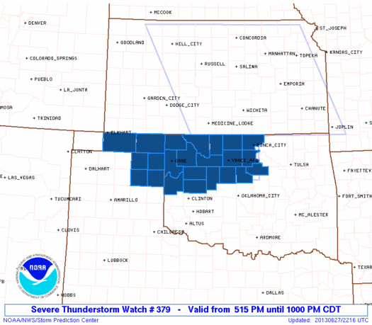
Initial List of Counties in SPC Severe Thunderstorm Watch 379 (WOU)
|
Back to Watch 379
|
 |
   WOUS64 KWNS 272209
   WOU9

   BULLETIN - IMMEDIATE BROADCAST REQUESTED
   SEVERE THUNDERSTORM WATCH OUTLINE UPDATE FOR WS 379
   NWS STORM PREDICTION CENTER NORMAN OK
   515 PM CDT THU JUN 27 2013

   SEVERE THUNDERSTORM WATCH 379 IS IN EFFECT UNTIL 1000 PM CDT
   FOR THE FOLLOWING LOCATIONS

   OKC003-007-011-039-043-045-047-053-059-071-073-083-093-103-119-
   129-139-151-153-280300-
   /O.NEW.KWNS.SV.A.0379.130627T2215Z-130628T0300Z/

   OK
   .    OKLAHOMA COUNTIES INCLUDED ARE

   ALFALFA              BEAVER              BLAINE
   CUSTER               DEWEY               ELLIS
   GARFIELD             GRANT               HARPER
   KAY                  KINGFISHER          LOGAN
   MAJOR                NOBLE               PAYNE
   ROGER MILLS          TEXAS               WOODS
   WOODWARD


   TXC211-295-357-393-280300-
   /O.NEW.KWNS.SV.A.0379.130627T2215Z-130628T0300Z/

   TX
   .    TEXAS COUNTIES INCLUDED ARE

   HEMPHILL             LIPSCOMB            OCHILTREE
   ROBERTS


   ATTN...WFO...OUN...AMA...
|
| Aviation Watch (SAW) for WW379 |
|---|
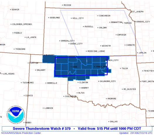 |
| Note:
The Aviation Watch (SAW) product is an approximation to the watch area.
The actual watch is depicted by the shaded areas. |
   SAW9
   WW 379 SEVERE TSTM OK TX 272215Z - 280300Z
   AXIS..40 STATUTE MILES NORTH AND SOUTH OF LINE..
   70W GAG/GAGE OK/ - 25SSE PNC/PONCA CITY OK/
   ..AVIATION COORDS.. 35NM N/S /46S LBL - 48E END/
   HAIL SURFACE AND ALOFT..1 INCH. WIND GUSTS..60 KNOTS.
   MAX TOPS TO 600. MEAN STORM MOTION VECTOR 34030.

   LAT...LON 36860102 36959693 35819693 35700102

   THIS IS AN APPROXIMATION TO THE WATCH AREA.  FOR A
   COMPLETE DEPICTION OF THE WATCH SEE WOUS64 KWNS
   FOR WOU9.
|
|


 @NWSSPC
