 Note:
The expiration time in the watch graphic is amended if the watch is
replaced, cancelled or extended.
Note:
Note:
The expiration time in the watch graphic is amended if the watch is
replaced, cancelled or extended.
Note: Click for
Watch Status Reports.
SEL4
URGENT - IMMEDIATE BROADCAST REQUESTED
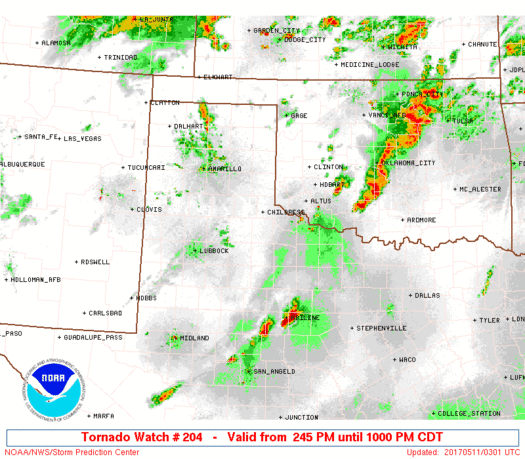
Tornado Watch Number 204
NWS Storm Prediction Center Norman OK
245 PM CDT Wed May 10 2017
The NWS Storm Prediction Center has issued a
* Tornado Watch for portions of
Southwest Oklahoma
Northwest Texas
* Effective this Wednesday afternoon and evening from 245 PM
until 1000 PM CDT.
* Primary threats include...
A few tornadoes possible
Scattered large hail and isolated very large hail events to 3
inches in diameter possible
Isolated damaging wind gusts to 70 mph possible
SUMMARY...Severe thunderstorms will continue to develop and increase
this afternoon, initially near the intersection of the dryline and a
modifying outflow boundary that extends northeastward into southwest
Oklahoma. Very large hail will be the primary risk, but damaging
winds are also possible, and a tornado risk exists especially later
today and/or near the modifying outflow boundary.
The tornado watch area is approximately along and 55 statute miles
north and south of a line from 85 miles west southwest of Childress
TX to 20 miles south southeast of Fort Sill OK. For a complete
depiction of the watch see the associated watch outline update
(WOUS64 KWNS WOU4).
PRECAUTIONARY/PREPAREDNESS ACTIONS...
REMEMBER...A Tornado Watch means conditions are favorable for
tornadoes and severe thunderstorms in and close to the watch
area. Persons in these areas should be on the lookout for
threatening weather conditions and listen for later statements
and possible warnings.
&&
OTHER WATCH INFORMATION...CONTINUE...WW 203...
AVIATION...Tornadoes and a few severe thunderstorms with hail
surface and aloft to 3 inches. Extreme turbulence and surface wind
gusts to 60 knots. A few cumulonimbi with maximum tops to 550. Mean
storm motion vector 24025.
...Guyer
   SEL4

   URGENT - IMMEDIATE BROADCAST REQUESTED
   Tornado Watch Number 204
   NWS Storm Prediction Center Norman OK
   245 PM CDT Wed May 10 2017

   The NWS Storm Prediction Center has issued a

   * Tornado Watch for portions of
     Southwest Oklahoma
     Northwest Texas

   * Effective this Wednesday afternoon and evening from 245 PM
     until 1000 PM CDT.

   * Primary threats include...
     A few tornadoes possible
     Scattered large hail and isolated very large hail events to 3
       inches in diameter possible
     Isolated damaging wind gusts to 70 mph possible

   SUMMARY...Severe thunderstorms will continue to develop and increase
   this afternoon, initially near the intersection of the dryline and a
   modifying outflow boundary that extends northeastward into southwest
   Oklahoma. Very large hail will be the primary risk, but damaging
   winds are also possible, and a tornado risk exists especially later
   today and/or near the modifying outflow boundary.

   The tornado watch area is approximately along and 55 statute miles
   north and south of a line from 85 miles west southwest of Childress
   TX to 20 miles south southeast of Fort Sill OK. For a complete
   depiction of the watch see the associated watch outline update
   (WOUS64 KWNS WOU4).

   PRECAUTIONARY/PREPAREDNESS ACTIONS...

   REMEMBER...A Tornado Watch means conditions are favorable for
   tornadoes and severe thunderstorms in and close to the watch
   area. Persons in these areas should be on the lookout for
   threatening weather conditions and listen for later statements
   and possible warnings.

   &&

   OTHER WATCH INFORMATION...CONTINUE...WW 203...

   AVIATION...Tornadoes and a few severe thunderstorms with hail
   surface and aloft to 3 inches. Extreme turbulence and surface wind
   gusts to 60 knots. A few cumulonimbi with maximum tops to 550. Mean
   storm motion vector 24025.

   ...Guyer
 Note:
The Aviation Watch (SAW) product is an approximation to the watch area.
The actual watch is depicted by the shaded areas.
Note:
The Aviation Watch (SAW) product is an approximation to the watch area.
The actual watch is depicted by the shaded areas.
SAW4
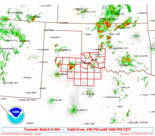
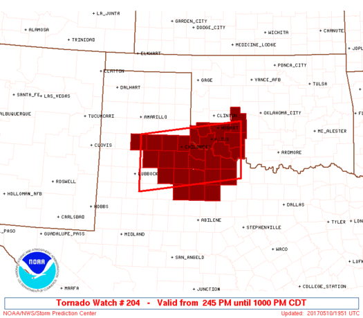
WW 204 TORNADO OK TX 101945Z - 110300Z
AXIS..55 STATUTE MILES NORTH AND SOUTH OF LINE..
85WSW CDS/CHILDRESS TX/ - 20SSE FSI/FORT SILL OK/
..AVIATION COORDS.. 50NM N/S /20NE LBB - 29NE SPS/
HAIL SURFACE AND ALOFT..3 INCHES. WIND GUSTS..60 KNOTS.
MAX TOPS TO 550. MEAN STORM MOTION VECTOR 24025.
LAT...LON 34750165 35189826 33599826 33150165
THIS IS AN APPROXIMATION TO THE WATCH AREA. FOR A
COMPLETE DEPICTION OF THE WATCH SEE WOUS64 KWNS
FOR WOU4.
Watch 204 Status Report Messages:
STATUS REPORT #3 ON WW 204

VALID 110140Z - 110240Z

SEVERE WEATHER THREAT CONTINUES RIGHT OF A LINE FROM 40 NNW ABI
TO 65 N ABI TO 45 SE CDS TO 40 SSW LTS TO 5 S LTS TO 20 WNW FSI
TO 15 NNW FSI TO 20 NW CHK TO 15 NNW CHK.

FOR ADDITIONAL INFORMATION SEE MESOSCALE DISCUSSION 689

..JEWELL..05/11/17

ATTN...WFO...OUN...LUB...SJT...

&&

STATUS REPORT FOR WT 204

SEVERE WEATHER THREAT CONTINUES FOR THE FOLLOWING AREAS

OKC015-031-033-065-141-110240-

OK
.    OKLAHOMA COUNTIES INCLUDED ARE

CADDO		     COMANCHE		 COTTON
JACKSON 	     TILLMAN
$$


TXC009-023-155-197-207-275-447-485-487-110240-

TX
.    TEXAS COUNTIES INCLUDED ARE

ARCHER		     BAYLOR		 FOARD
HARDEMAN	     HASKELL		 KNOX
THROCKMORTON	     WICHITA		 WILBARGER
$$


THE WATCH STATUS MESSAGE IS FOR GUIDANCE PURPOSES ONLY.  PLEASE
REFER TO WATCH COUNTY NOTIFICATION STATEMENTS FOR OFFICIAL
INFORMATION ON COUNTIES...INDEPENDENT CITIES AND MARINE ZONES
CLEARED FROM SEVERE THUNDERSTORM AND TORNADO WATCHES.
$$

STATUS REPORT #2 ON WW 204

VALID 102210Z - 102340Z

SEVERE WEATHER THREAT CONTINUES RIGHT OF A LINE FROM 40 NNW ABI
TO 70 SSE CDS TO 50 SSE CDS TO 30 SSE CDS TO 15 SSW CDS TO 25 W
CDS TO 40 NE PVW TO 30 S AMA.

..JEWELL..05/10/17

ATTN...WFO...OUN...LUB...SJT...

&&

STATUS REPORT FOR WT 204

SEVERE WEATHER THREAT CONTINUES FOR THE FOLLOWING AREAS

OKC015-031-033-055-057-065-075-141-102340-

OK
.    OKLAHOMA COUNTIES INCLUDED ARE

CADDO		     COMANCHE		 COTTON
GREER		     HARMON		 JACKSON
KIOWA		     TILLMAN
$$


TXC009-023-075-101-155-191-197-207-275-447-485-487-102340-

TX
.    TEXAS COUNTIES INCLUDED ARE

ARCHER		     BAYLOR		 CHILDRESS
COTTLE		     FOARD		 HALL
HARDEMAN	     HASKELL		 KNOX
THROCKMORTON	     WICHITA		 WILBARGER
$$


THE WATCH STATUS MESSAGE IS FOR GUIDANCE PURPOSES ONLY.  PLEASE
REFER TO WATCH COUNTY NOTIFICATION STATEMENTS FOR OFFICIAL
INFORMATION ON COUNTIES...INDEPENDENT CITIES AND MARINE ZONES
CLEARED FROM SEVERE THUNDERSTORM AND TORNADO WATCHES.
$$

STATUS REPORT #1 ON WW 204

VALID 102140Z - 102240Z

SEVERE WEATHER THREAT CONTINUES RIGHT OF A LINE FROM 15 S PVW TO
15 NE PVW TO 30 NNE PVW TO 20 S AMA.

..JEWELL..05/10/17

ATTN...WFO...OUN...LUB...SJT...

&&

STATUS REPORT FOR WT 204

SEVERE WEATHER THREAT CONTINUES FOR THE FOLLOWING AREAS

OKC015-031-033-055-057-065-075-141-102240-

OK
.    OKLAHOMA COUNTIES INCLUDED ARE

CADDO		     COMANCHE		 COTTON
GREER		     HARMON		 JACKSON
KIOWA		     TILLMAN
$$


TXC009-023-045-075-101-125-153-155-191-197-207-269-275-345-433-
447-485-487-102240-

TX
.    TEXAS COUNTIES INCLUDED ARE

ARCHER		     BAYLOR		 BRISCOE
CHILDRESS	     COTTLE		 DICKENS
FLOYD		     FOARD		 HALL
HARDEMAN	     HASKELL		 KING
KNOX		     MOTLEY		 STONEWALL
THROCKMORTON	     WICHITA		 WILBARGER
$$


THE WATCH STATUS MESSAGE IS FOR GUIDANCE PURPOSES ONLY.  PLEASE
REFER TO WATCH COUNTY NOTIFICATION STATEMENTS FOR OFFICIAL
INFORMATION ON COUNTIES...INDEPENDENT CITIES AND MARINE ZONES
CLEARED FROM SEVERE THUNDERSTORM AND TORNADO WATCHES.
$$
Note:
Click for Complete Product Text.
Tornadoes
Probability of 2 or more tornadoes
|
Mod (50%)
|
Probability of 1 or more strong (F2-F5) tornadoes
|
Low (20%)
|
Wind
Probability of 10 or more severe wind events
|
Low (20%)
|
Probability of 1 or more wind events > 65 knots
|
Low (10%)
|
Hail
Probability of 10 or more severe hail events
|
Mod (50%)
|
Probability of 1 or more hailstones > 2 inches
|
Mod (40%)
|
Combined Severe Hail/Wind
Probability of 6 or more combined severe hail/wind events
|
High (70%)
|
For each watch, probabilities for particular events inside the watch
(listed above in each table) are determined by the issuing forecaster.
The "Low" category contains probability values ranging from less than 2%
to 20% (F2-F5 tornadoes), less than 5% to 20% (all other probabilities),
"Moderate" from 30% to 60%, and "High" from 70% to greater than 95%.
High values are bolded and lighter in color to provide awareness of
an increased threat for a particular event.


 @NWSSPC


