 Note:
The expiration time in the watch graphic is amended if the watch is
replaced, cancelled or extended.
Note:
Note:
The expiration time in the watch graphic is amended if the watch is
replaced, cancelled or extended.
Note: Click for
Watch Status Reports.
SEL0
URGENT - IMMEDIATE BROADCAST REQUESTED
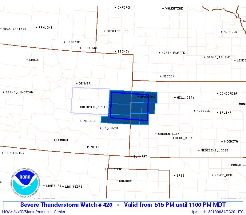
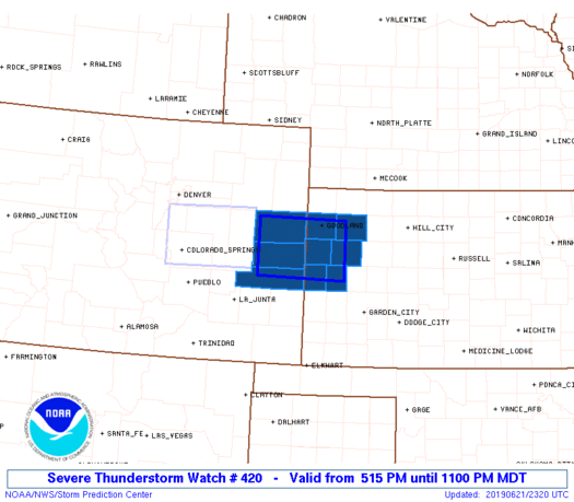
Severe Thunderstorm Watch Number 420
NWS Storm Prediction Center Norman OK
515 PM MDT Fri Jun 21 2019
The NWS Storm Prediction Center has issued a
* Severe Thunderstorm Watch for portions of
east central Colorado
northwestern Kansas
* Effective this Friday afternoon and evening from 515 PM until
1100 PM MDT.
* Primary threats include...
Scattered large hail and isolated very large hail events to 2
inches in diameter possible
Scattered damaging wind gusts to 70 mph possible
A tornado or two possible
SUMMARY...Strong to severe thunderstorm development, including
isolated supercells, is expected to gradually spread eastward into
the region this evening and pose a risk for severe hail and locally
strong surface gusts.
The severe thunderstorm watch area is approximately along and 35
statute miles north and south of a line from 45 miles west southwest
of Burlington CO to 40 miles southeast of Goodland KS. For a
complete depiction of the watch see the associated watch outline
update (WOUS64 KWNS WOU0).
PRECAUTIONARY/PREPAREDNESS ACTIONS...
REMEMBER...A Severe Thunderstorm Watch means conditions are
favorable for severe thunderstorms in and close to the watch area.
Persons in these areas should be on the lookout for threatening
weather conditions and listen for later statements and possible
warnings. Severe thunderstorms can and occasionally do produce
tornadoes.
&&
OTHER WATCH INFORMATION...CONTINUE...WW 417...WW 418...WW 419...
AVIATION...A few severe thunderstorms with hail surface and aloft to
2 inches. Extreme turbulence and surface wind gusts to 60 knots. A
few cumulonimbi with maximum tops to 450. Mean storm motion vector
27020.
...Kerr

   SEL0

   URGENT - IMMEDIATE BROADCAST REQUESTED
   Severe Thunderstorm Watch Number 420
   NWS Storm Prediction Center Norman OK
   515 PM MDT Fri Jun 21 2019

   The NWS Storm Prediction Center has issued a

   * Severe Thunderstorm Watch for portions of
     east central Colorado
     northwestern Kansas

   * Effective this Friday afternoon and evening from 515 PM until
     1100 PM MDT.

   * Primary threats include...
     Scattered large hail and isolated very large hail events to 2
       inches in diameter possible
     Scattered damaging wind gusts to 70 mph possible
     A tornado or two possible

   SUMMARY...Strong to severe thunderstorm development, including
   isolated supercells, is expected to gradually spread eastward into
   the region this evening and pose a risk for severe hail and locally
   strong surface gusts.

   The severe thunderstorm watch area is approximately along and 35
   statute miles north and south of a line from 45 miles west southwest
   of Burlington CO to 40 miles southeast of Goodland KS. For a
   complete depiction of the watch see the associated watch outline
   update (WOUS64 KWNS WOU0).

   PRECAUTIONARY/PREPAREDNESS ACTIONS...

   REMEMBER...A Severe Thunderstorm Watch means conditions are
   favorable for severe thunderstorms in and close to the watch area.
   Persons in these areas should be on the lookout for threatening
   weather conditions and listen for later statements and possible
   warnings. Severe thunderstorms can and occasionally do produce
   tornadoes.

   &&

   OTHER WATCH INFORMATION...CONTINUE...WW 417...WW 418...WW 419...

   AVIATION...A few severe thunderstorms with hail surface and aloft to
   2 inches. Extreme turbulence and surface wind gusts to 60 knots. A
   few cumulonimbi with maximum tops to 450. Mean storm motion vector
   27020.

   ...Kerr
 Note:
The Aviation Watch (SAW) product is an approximation to the watch area.
The actual watch is depicted by the shaded areas.
Note:
The Aviation Watch (SAW) product is an approximation to the watch area.
The actual watch is depicted by the shaded areas.
   SAW0
   WW 420 SEVERE TSTM CO KS 212315Z - 220500Z
   AXIS..35 STATUTE MILES NORTH AND SOUTH OF LINE..
   45WSW ITR/BURLINGTON CO/ - 40SE GLD/GOODLAND KS/
   ..AVIATION COORDS.. 30NM N/S /50NNW LAA - 36SE GLD/
   HAIL SURFACE AND ALOFT..2 INCHES. WIND GUSTS..60 KNOTS.
   MAX TOPS TO 450. MEAN STORM MOTION VECTOR 27020.

   LAT...LON 39490305 39450116 38430116 38470305

   THIS IS AN APPROXIMATION TO THE WATCH AREA.  FOR A
   COMPLETE DEPICTION OF THE WATCH SEE WOUS64 KWNS
   FOR WOU0.
Watch 420 Status Report Messages:
STATUS REPORT #2 ON WW 420

VALID 220245Z - 220340Z

THE SEVERE WEATHER THREAT CONTINUES ACROSS THE ENTIRE WATCH AREA.

FOR ADDITIONAL INFORMATION SEE MESOSCALE DISCUSSION 1188

..SQUITIERI..06/22/19

ATTN...WFO...GLD...PUB...

&&

STATUS REPORT FOR WS 420

SEVERE WEATHER THREAT CONTINUES FOR THE FOLLOWING AREAS

COC017-061-063-220340-

CO
.    COLORADO COUNTIES INCLUDED ARE

CHEYENNE	     KIOWA		 KIT CARSON
$$


KSC071-109-181-193-199-203-220340-

KS
.    KANSAS COUNTIES INCLUDED ARE

GREELEY 	     LOGAN		 SHERMAN
THOMAS		     WALLACE		 WICHITA
$$


THE WATCH STATUS MESSAGE IS FOR GUIDANCE PURPOSES ONLY.  PLEASE
REFER TO WATCH COUNTY NOTIFICATION STATEMENTS FOR OFFICIAL
INFORMATION ON COUNTIES...INDEPENDENT CITIES AND MARINE ZONES
CLEARED FROM SEVERE THUNDERSTORM AND TORNADO WATCHES.
$$

STATUS REPORT #1 ON WW 420

VALID 220120Z - 220240Z

THE SEVERE WEATHER THREAT CONTINUES ACROSS THE ENTIRE WATCH AREA.

..SQUITIERI..06/22/19

ATTN...WFO...GLD...PUB...

&&

STATUS REPORT FOR WS 420

SEVERE WEATHER THREAT CONTINUES FOR THE FOLLOWING AREAS

COC017-061-063-220240-

CO
.    COLORADO COUNTIES INCLUDED ARE

CHEYENNE	     KIOWA		 KIT CARSON
$$


KSC071-109-181-193-199-203-220240-

KS
.    KANSAS COUNTIES INCLUDED ARE

GREELEY 	     LOGAN		 SHERMAN
THOMAS		     WALLACE		 WICHITA
$$


THE WATCH STATUS MESSAGE IS FOR GUIDANCE PURPOSES ONLY.  PLEASE
REFER TO WATCH COUNTY NOTIFICATION STATEMENTS FOR OFFICIAL
INFORMATION ON COUNTIES...INDEPENDENT CITIES AND MARINE ZONES
CLEARED FROM SEVERE THUNDERSTORM AND TORNADO WATCHES.
$$
Note:
Click for Complete Product Text.
Tornadoes
Probability of 2 or more tornadoes
|
Low (20%)
|
Probability of 1 or more strong (EF2-EF5) tornadoes
|
Low (<2%)
|
Wind
Probability of 10 or more severe wind events
|
Mod (40%)
|
Probability of 1 or more wind events > 65 knots
|
Low (20%)
|
Hail
Probability of 10 or more severe hail events
|
Mod (40%)
|
Probability of 1 or more hailstones > 2 inches
|
Mod (30%)
|
Combined Severe Hail/Wind
Probability of 6 or more combined severe hail/wind events
|
High (70%)
|
For each watch, probabilities for particular events inside the watch
(listed above in each table) are determined by the issuing forecaster.
The "Low" category contains probability values ranging from less than 2%
to 20% (EF2-EF5 tornadoes), less than 5% to 20% (all other probabilities),
"Moderate" from 30% to 60%, and "High" from 70% to greater than 95%.
High values are bolded and lighter in color to provide awareness of
an increased threat for a particular event.


 @NWSSPC