Note:
The expiration time in the watch graphic is amended if the watch is
replaced, cancelled or extended.
Note:
Note:
The expiration time in the watch graphic is amended if the watch is
replaced, cancelled or extended.
Note: Click for
Watch Status Reports.
SEL1
URGENT - IMMEDIATE BROADCAST REQUESTED
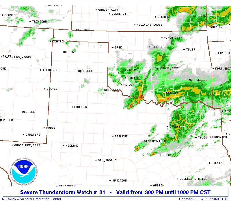
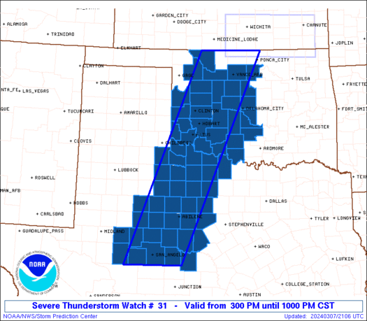
Severe Thunderstorm Watch Number 31
NWS Storm Prediction Center Norman OK
300 PM CST Thu Mar 7 2024
The NWS Storm Prediction Center has issued a
* Severe Thunderstorm Watch for portions of
Western Oklahoma
West-central and western North Texas
* Effective this Thursday afternoon and evening from 300 PM until
1000 PM CST.
* Primary threats include...
Scattered large hail likely with isolated very large hail events
to 2.5 inches in diameter possible
Scattered damaging wind gusts to 70 mph possible
A tornado or two possible
SUMMARY...Thunderstorms are slowly intensifying in vicinity of a
dryline over western Oklahoma and west Texas. This activity will
track eastward through the afternoon and early evening, posing a
risk of large hail and damaging winds.
The severe thunderstorm watch area is approximately along and 55
statute miles east and west of a line from 20 miles south of San
Angelo TX to 40 miles east northeast of Alva OK. For a complete
depiction of the watch see the associated watch outline update
(WOUS64 KWNS WOU1).
PRECAUTIONARY/PREPAREDNESS ACTIONS...
REMEMBER...A Severe Thunderstorm Watch means conditions are
favorable for severe thunderstorms in and close to the watch area.
Persons in these areas should be on the lookout for threatening
weather conditions and listen for later statements and possible
warnings. Severe thunderstorms can and occasionally do produce
tornadoes.
&&
OTHER WATCH INFORMATION...CONTINUE...WW 30...
AVIATION...A few severe thunderstorms with hail surface and aloft to
2.5 inches. Extreme turbulence and surface wind gusts to 60 knots. A
few cumulonimbi with maximum tops to 450. Mean storm motion vector
26030.
...Hart
   SEL1

   URGENT - IMMEDIATE BROADCAST REQUESTED
   Severe Thunderstorm Watch Number 31
   NWS Storm Prediction Center Norman OK
   300 PM CST Thu Mar 7 2024

   The NWS Storm Prediction Center has issued a

   * Severe Thunderstorm Watch for portions of
     Western Oklahoma
     West-central and western North Texas

   * Effective this Thursday afternoon and evening from 300 PM until
     1000 PM CST.

   * Primary threats include...
     Scattered large hail likely with isolated very large hail events
       to 2.5 inches in diameter possible
     Scattered damaging wind gusts to 70 mph possible
     A tornado or two possible

   SUMMARY...Thunderstorms are slowly intensifying in vicinity of a
   dryline over western Oklahoma and west Texas.  This activity will
   track eastward through the afternoon and early evening, posing a
   risk of large hail and damaging winds.

   The severe thunderstorm watch area is approximately along and 55
   statute miles east and west of a line from 20 miles south of San
   Angelo TX to 40 miles east northeast of Alva OK. For a complete
   depiction of the watch see the associated watch outline update
   (WOUS64 KWNS WOU1).

   PRECAUTIONARY/PREPAREDNESS ACTIONS...

   REMEMBER...A Severe Thunderstorm Watch means conditions are
   favorable for severe thunderstorms in and close to the watch area.
   Persons in these areas should be on the lookout for threatening
   weather conditions and listen for later statements and possible
   warnings. Severe thunderstorms can and occasionally do produce
   tornadoes.

   &&

   OTHER WATCH INFORMATION...CONTINUE...WW 30...

   AVIATION...A few severe thunderstorms with hail surface and aloft to
   2.5 inches. Extreme turbulence and surface wind gusts to 60 knots. A
   few cumulonimbi with maximum tops to 450. Mean storm motion vector
   26030.

   ...Hart
 Note:
The Aviation Watch (SAW) product is an approximation to the watch area.
The actual watch is depicted by the shaded areas.
Note:
The Aviation Watch (SAW) product is an approximation to the watch area.
The actual watch is depicted by the shaded areas.
   SAW1
   WW 31 SEVERE TSTM OK TX 072100Z - 080400Z
   AXIS..55 STATUTE MILES EAST AND WEST OF LINE..
   20S SJT/SAN ANGELO TX/ - 40ENE AVK/ALVA OK/
   ..AVIATION COORDS.. 50NM E/W /18S SJT - 39N END/
   HAIL SURFACE AND ALOFT..2.5 INCHES. WIND GUSTS..60 KNOTS.
   MAX TOPS TO 450. MEAN STORM MOTION VECTOR 26030.

   LAT...LON 31080143 36999900 36999700 31089957

   THIS IS AN APPROXIMATION TO THE WATCH AREA.  FOR A
   COMPLETE DEPICTION OF THE WATCH SEE WOUS64 KWNS
   FOR WOU1.
Watch 31 Status Report Messages:
STATUS REPORT #6 ON WW 31

VALID 080240Z - 080340Z

SEVERE WEATHER THREAT CONTINUES RIGHT OF A LINE FROM 70 WSW SJT
TO 45 E BGS TO 55 NW ABI TO 15 SE LTS TO 20 W CHK TO 35 NW CQB.

..THORNTON..03/08/24

ATTN...WFO...OUN...SJT...LUB...FWD...MAF...

&&

STATUS REPORT FOR WS 31

SEVERE WEATHER THREAT CONTINUES FOR THE FOLLOWING AREAS

OKC027-031-033-049-051-067-087-109-137-141-080340-

OK
.    OKLAHOMA COUNTIES INCLUDED ARE

CLEVELAND	     COMANCHE		 COTTON
GARVIN		     GRADY		 JEFFERSON
MCCLAIN 	     OKLAHOMA		 STEPHENS
TILLMAN
$$


TXC009-023-049-059-077-081-083-095-133-151-207-235-253-275-307-
353-399-417-429-431-441-447-451-485-487-503-080340-

TX
.    TEXAS COUNTIES INCLUDED ARE

ARCHER		     BAYLOR		 BROWN
CALLAHAN	     CLAY		 COKE
COLEMAN 	     CONCHO		 EASTLAND
FISHER		     HASKELL		 IRION
JONES		     KNOX		 MCCULLOCH
NOLAN		     RUNNELS		 SHACKELFORD
STEPHENS	     STERLING		 TAYLOR
THROCKMORTON	     TOM GREEN		 WICHITA
WILBARGER	     YOUNG
$$


THE WATCH STATUS MESSAGE IS FOR GUIDANCE PURPOSES ONLY.  PLEASE
REFER TO WATCH COUNTY NOTIFICATION STATEMENTS FOR OFFICIAL
INFORMATION ON COUNTIES...INDEPENDENT CITIES AND MARINE ZONES
CLEARED FROM SEVERE THUNDERSTORM AND TORNADO WATCHES.
$$

STATUS REPORT #5 ON WW 31

VALID 080140Z - 080240Z

SEVERE WEATHER THREAT CONTINUES RIGHT OF A LINE FROM 45 N CDS TO
25 ENE CSM TO 25 NNW OKC TO 25 N PNC.

FOR ADDITIONAL INFORMATION SEE MESOSCALE DISCUSSION 200

..THORNTON..03/08/24

ATTN...WFO...OUN...SJT...LUB...FWD...MAF...

&&

STATUS REPORT FOR WS 31

SEVERE WEATHER THREAT CONTINUES FOR THE FOLLOWING AREAS

OKC015-017-027-031-033-049-051-055-057-065-067-075-083-087-103-
109-137-141-149-080240-

OK
.    OKLAHOMA COUNTIES INCLUDED ARE

CADDO		     CANADIAN		 CLEVELAND
COMANCHE	     COTTON		 GARVIN
GRADY		     GREER		 HARMON
JACKSON 	     JEFFERSON		 KIOWA
LOGAN		     MCCLAIN		 NOBLE
OKLAHOMA	     STEPHENS		 TILLMAN
WASHITA
$$


TXC009-023-049-059-077-081-083-095-101-133-151-155-173-197-207-
235-253-269-275-307-335-353-383-399-415-417-429-431-433-441-447-
451-485-487-503-080240-

TX
.    TEXAS COUNTIES INCLUDED ARE

ARCHER		     BAYLOR		 BROWN
CALLAHAN	     CLAY		 COKE
COLEMAN 	     CONCHO		 COTTLE
EASTLAND	     FISHER		 FOARD
GLASSCOCK	     HARDEMAN		 HASKELL
IRION		     JONES		 KING
KNOX		     MCCULLOCH		 MITCHELL
NOLAN		     REAGAN		 RUNNELS
SCURRY		     SHACKELFORD	 STEPHENS
STERLING	     STONEWALL		 TAYLOR
THROCKMORTON	     TOM GREEN		 WICHITA
WILBARGER	     YOUNG
$$


THE WATCH STATUS MESSAGE IS FOR GUIDANCE PURPOSES ONLY.  PLEASE
REFER TO WATCH COUNTY NOTIFICATION STATEMENTS FOR OFFICIAL
INFORMATION ON COUNTIES...INDEPENDENT CITIES AND MARINE ZONES
CLEARED FROM SEVERE THUNDERSTORM AND TORNADO WATCHES.
$$

STATUS REPORT #4 ON WW 31

VALID 080045Z - 080140Z

SEVERE WEATHER THREAT CONTINUES RIGHT OF A LINE FROM 45 N CDS TO
30 ENE CSM TO 10 WSW PNC TO 25 N PNC.

FOR ADDITIONAL INFORMATION SEE MESOSCALE DISCUSSION 200

..THORNTON..03/08/24

ATTN...WFO...OUN...SJT...LUB...FWD...MAF...

&&

STATUS REPORT FOR WS 31

SEVERE WEATHER THREAT CONTINUES FOR THE FOLLOWING AREAS

OKC015-017-027-031-033-049-051-055-057-065-067-073-075-083-087-
103-109-137-141-149-080140-

OK
.    OKLAHOMA COUNTIES INCLUDED ARE

CADDO		     CANADIAN		 CLEVELAND
COMANCHE	     COTTON		 GARVIN
GRADY		     GREER		 HARMON
JACKSON 	     JEFFERSON		 KINGFISHER
KIOWA		     LOGAN		 MCCLAIN
NOBLE		     OKLAHOMA		 STEPHENS
TILLMAN 	     WASHITA
$$


TXC009-023-049-059-077-081-083-095-101-133-151-155-173-197-207-
235-253-269-275-307-335-353-383-399-415-417-429-431-433-441-447-
451-485-487-503-080140-

TX
.    TEXAS COUNTIES INCLUDED ARE

ARCHER		     BAYLOR		 BROWN
CALLAHAN	     CLAY		 COKE
COLEMAN 	     CONCHO		 COTTLE
EASTLAND	     FISHER		 FOARD
GLASSCOCK	     HARDEMAN		 HASKELL
IRION		     JONES		 KING
KNOX		     MCCULLOCH		 MITCHELL
NOLAN		     REAGAN		 RUNNELS
SCURRY		     SHACKELFORD	 STEPHENS
STERLING	     STONEWALL		 TAYLOR
THROCKMORTON	     TOM GREEN		 WICHITA
WILBARGER	     YOUNG
$$


THE WATCH STATUS MESSAGE IS FOR GUIDANCE PURPOSES ONLY.  PLEASE
REFER TO WATCH COUNTY NOTIFICATION STATEMENTS FOR OFFICIAL
INFORMATION ON COUNTIES...INDEPENDENT CITIES AND MARINE ZONES
CLEARED FROM SEVERE THUNDERSTORM AND TORNADO WATCHES.
$$

STATUS REPORT #3 ON WW 31

VALID 072340Z - 080040Z

SEVERE WEATHER THREAT CONTINUES RIGHT OF A LINE FROM 45 NNE CDS
TO 15 W CSM TO 25 SW AVK TO 30 WSW P28.

..THORNTON..03/07/24

ATTN...WFO...OUN...SJT...LUB...FWD...MAF...

&&

STATUS REPORT FOR WS 31

SEVERE WEATHER THREAT CONTINUES FOR THE FOLLOWING AREAS

OKC011-015-017-027-031-033-039-043-047-049-051-055-057-065-067-
073-075-083-087-093-103-109-137-141-149-151-080040-

OK
.    OKLAHOMA COUNTIES INCLUDED ARE

BLAINE		     CADDO		 CANADIAN
CLEVELAND	     COMANCHE		 COTTON
CUSTER		     DEWEY		 GARFIELD
GARVIN		     GRADY		 GREER
HARMON		     JACKSON		 JEFFERSON
KINGFISHER	     KIOWA		 LOGAN
MCCLAIN 	     MAJOR		 NOBLE
OKLAHOMA	     STEPHENS		 TILLMAN
WASHITA 	     WOODS
$$


TXC009-023-049-059-077-081-083-095-101-133-151-155-173-197-207-
235-253-269-275-307-335-353-383-399-415-417-429-431-433-441-447-
451-485-487-503-080040-

TX
.    TEXAS COUNTIES INCLUDED ARE

ARCHER		     BAYLOR		 BROWN
CALLAHAN	     CLAY		 COKE
COLEMAN 	     CONCHO		 COTTLE
EASTLAND	     FISHER		 FOARD
GLASSCOCK	     HARDEMAN		 HASKELL
IRION		     JONES		 KING
KNOX		     MCCULLOCH		 MITCHELL
NOLAN		     REAGAN		 RUNNELS
SCURRY		     SHACKELFORD	 STEPHENS
STERLING	     STONEWALL		 TAYLOR
THROCKMORTON	     TOM GREEN		 WICHITA
WILBARGER	     YOUNG
$$


THE WATCH STATUS MESSAGE IS FOR GUIDANCE PURPOSES ONLY.  PLEASE
REFER TO WATCH COUNTY NOTIFICATION STATEMENTS FOR OFFICIAL
INFORMATION ON COUNTIES...INDEPENDENT CITIES AND MARINE ZONES
CLEARED FROM SEVERE THUNDERSTORM AND TORNADO WATCHES.
$$

STATUS REPORT #2 ON WW 31

VALID 072250Z - 072340Z

SEVERE WEATHER THREAT CONTINUES RIGHT OF A LINE FROM 45 NNE CDS
TO 15 W CSM TO 25 SW AVK TO 30 WSW P28.

..THORNTON..03/07/24

ATTN...WFO...OUN...SJT...LUB...FWD...MAF...

&&

STATUS REPORT FOR WS 31

SEVERE WEATHER THREAT CONTINUES FOR THE FOLLOWING AREAS

OKC011-015-017-027-031-033-039-043-047-049-051-055-057-065-067-
073-075-083-087-093-103-109-137-141-149-151-072340-

OK
.    OKLAHOMA COUNTIES INCLUDED ARE

BLAINE		     CADDO		 CANADIAN
CLEVELAND	     COMANCHE		 COTTON
CUSTER		     DEWEY		 GARFIELD
GARVIN		     GRADY		 GREER
HARMON		     JACKSON		 JEFFERSON
KINGFISHER	     KIOWA		 LOGAN
MCCLAIN 	     MAJOR		 NOBLE
OKLAHOMA	     STEPHENS		 TILLMAN
WASHITA 	     WOODS
$$


TXC009-023-049-059-077-081-083-095-101-133-151-155-173-197-207-
235-253-269-275-307-335-353-383-399-415-417-429-431-433-441-447-
451-485-487-503-072340-

TX
.    TEXAS COUNTIES INCLUDED ARE

ARCHER		     BAYLOR		 BROWN
CALLAHAN	     CLAY		 COKE
COLEMAN 	     CONCHO		 COTTLE
EASTLAND	     FISHER		 FOARD
GLASSCOCK	     HARDEMAN		 HASKELL
IRION		     JONES		 KING
KNOX		     MCCULLOCH		 MITCHELL
NOLAN		     REAGAN		 RUNNELS
SCURRY		     SHACKELFORD	 STEPHENS
STERLING	     STONEWALL		 TAYLOR
THROCKMORTON	     TOM GREEN		 WICHITA
WILBARGER	     YOUNG
$$


THE WATCH STATUS MESSAGE IS FOR GUIDANCE PURPOSES ONLY.  PLEASE
REFER TO WATCH COUNTY NOTIFICATION STATEMENTS FOR OFFICIAL
INFORMATION ON COUNTIES...INDEPENDENT CITIES AND MARINE ZONES
CLEARED FROM SEVERE THUNDERSTORM AND TORNADO WATCHES.
$$

STATUS REPORT #1 ON WW 31

VALID 072125Z - 072240Z

THE SEVERE WEATHER THREAT CONTINUES ACROSS THE ENTIRE WATCH AREA.

..DEAN..03/07/24

ATTN...WFO...OUN...SJT...LUB...FWD...MAF...

&&

STATUS REPORT FOR WS 31

SEVERE WEATHER THREAT CONTINUES FOR THE FOLLOWING AREAS

OKC009-011-015-017-027-031-033-039-043-047-049-051-055-057-065-
067-073-075-083-087-093-103-109-129-137-141-149-151-153-
072240-

OK
.    OKLAHOMA COUNTIES INCLUDED ARE

BECKHAM 	     BLAINE		 CADDO
CANADIAN	     CLEVELAND		 COMANCHE
COTTON		     CUSTER		 DEWEY
GARFIELD	     GARVIN		 GRADY
GREER		     HARMON		 JACKSON
JEFFERSON	     KINGFISHER 	 KIOWA
LOGAN		     MCCLAIN		 MAJOR
NOBLE		     OKLAHOMA		 ROGER MILLS
STEPHENS	     TILLMAN		 WASHITA
WOODS		     WOODWARD
$$


TXC009-023-049-059-077-081-083-095-101-133-151-155-173-197-207-
235-253-269-275-307-335-353-383-399-415-417-429-431-433-441-447-
451-485-487-503-072240-

TX
.    TEXAS COUNTIES INCLUDED ARE

ARCHER		     BAYLOR		 BROWN
CALLAHAN	     CLAY		 COKE
COLEMAN 	     CONCHO		 COTTLE
EASTLAND	     FISHER		 FOARD
GLASSCOCK	     HARDEMAN		 HASKELL
IRION		     JONES		 KING
KNOX		     MCCULLOCH		 MITCHELL
NOLAN		     REAGAN		 RUNNELS
SCURRY		     SHACKELFORD	 STEPHENS
STERLING	     STONEWALL		 TAYLOR
THROCKMORTON	     TOM GREEN		 WICHITA
WILBARGER	     YOUNG
$$


THE WATCH STATUS MESSAGE IS FOR GUIDANCE PURPOSES ONLY.  PLEASE
REFER TO WATCH COUNTY NOTIFICATION STATEMENTS FOR OFFICIAL
INFORMATION ON COUNTIES...INDEPENDENT CITIES AND MARINE ZONES
CLEARED FROM SEVERE THUNDERSTORM AND TORNADO WATCHES.
$$
Note:
Click for Complete Product Text.
Tornadoes
Probability of 2 or more tornadoes
|
Low (20%)
|
Probability of 1 or more strong (EF2-EF5) tornadoes
|
Low (5%)
|
Wind
Probability of 10 or more severe wind events
|
Mod (40%)
|
Probability of 1 or more wind events > 65 knots
|
Low (20%)
|
Hail
Probability of 10 or more severe hail events
|
High (70%)
|
Probability of 1 or more hailstones > 2 inches
|
Mod (50%)
|
Combined Severe Hail/Wind
Probability of 6 or more combined severe hail/wind events
|
High (90%)
|
For each watch, probabilities for particular events inside the watch
(listed above in each table) are determined by the issuing forecaster.
The "Low" category contains probability values ranging from less than 2%
to 20% (EF2-EF5 tornadoes), less than 5% to 20% (all other probabilities),
"Moderate" from 30% to 60%, and "High" from 70% to greater than 95%.
High values are bolded and lighter in color to provide awareness of
an increased threat for a particular event.


 @NWSSPC