 Note:
The expiration time in the watch graphic is amended if the watch is
replaced, cancelled or extended.
Note:
Note:
The expiration time in the watch graphic is amended if the watch is
replaced, cancelled or extended.
Note: Click for
Watch Status Reports.
SEL7
URGENT - IMMEDIATE BROADCAST REQUESTED
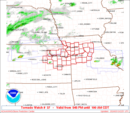
Tornado Watch Number 37
NWS Storm Prediction Center Norman OK
545 PM CDT Wed Mar 13 2024
The NWS Storm Prediction Center has issued a
* Tornado Watch for portions of
Eastern Kansas
Northern Missouri
* Effective this Wednesday afternoon and Thursday morning from
545 PM until 100 AM CDT.
* Primary threats include...
A couple tornadoes possible
Scattered large hail and isolated very large hail events to 2.5
inches in diameter likely
Scattered damaging wind gusts to 70 mph likely
SUMMARY...Scattered thunderstorms will affect the watch area through
the evening, with a few supercells possible. Very large hail and a
tornado or two may occur with the strongest cells.
The tornado watch area is approximately along and 55 statute miles
north and south of a line from 35 miles southwest of Manhattan KS to
60 miles east southeast of Chillicothe MO. For a complete depiction
of the watch see the associated watch outline update (WOUS64 KWNS
WOU7).
PRECAUTIONARY/PREPAREDNESS ACTIONS...
REMEMBER...A Tornado Watch means conditions are favorable for
tornadoes and severe thunderstorms in and close to the watch
area. Persons in these areas should be on the lookout for
threatening weather conditions and listen for later statements
and possible warnings.
&&
OTHER WATCH INFORMATION...CONTINUE...WW 35...WW 36...
AVIATION...Tornadoes and a few severe thunderstorms with hail
surface and aloft to 2.5 inches. Extreme turbulence and surface wind
gusts to 60 knots. A few cumulonimbi with maximum tops to 450. Mean
storm motion vector 25035.
...Hart

   SEL7

   URGENT - IMMEDIATE BROADCAST REQUESTED
   Tornado Watch Number 37
   NWS Storm Prediction Center Norman OK
   545 PM CDT Wed Mar 13 2024

   The NWS Storm Prediction Center has issued a

   * Tornado Watch for portions of
     Eastern Kansas
     Northern Missouri

   * Effective this Wednesday afternoon and Thursday morning from
     545 PM until 100 AM CDT.

   * Primary threats include...
     A couple tornadoes possible
     Scattered large hail and isolated very large hail events to 2.5
       inches in diameter likely
     Scattered damaging wind gusts to 70 mph likely

   SUMMARY...Scattered thunderstorms will affect the watch area through
   the evening, with a few supercells possible.  Very large hail and a
   tornado or two may occur with the strongest cells.

   The tornado watch area is approximately along and 55 statute miles
   north and south of a line from 35 miles southwest of Manhattan KS to
   60 miles east southeast of Chillicothe MO. For a complete depiction
   of the watch see the associated watch outline update (WOUS64 KWNS
   WOU7).

   PRECAUTIONARY/PREPAREDNESS ACTIONS...

   REMEMBER...A Tornado Watch means conditions are favorable for
   tornadoes and severe thunderstorms in and close to the watch
   area. Persons in these areas should be on the lookout for
   threatening weather conditions and listen for later statements
   and possible warnings.

   &&

   OTHER WATCH INFORMATION...CONTINUE...WW 35...WW 36...

   AVIATION...Tornadoes and a few severe thunderstorms with hail
   surface and aloft to 2.5 inches. Extreme turbulence and surface wind
   gusts to 60 knots. A few cumulonimbi with maximum tops to 450. Mean
   storm motion vector 25035.

   ...Hart
 Note:
The Aviation Watch (SAW) product is an approximation to the watch area.
The actual watch is depicted by the shaded areas.
Note:
The Aviation Watch (SAW) product is an approximation to the watch area.
The actual watch is depicted by the shaded areas.
SAW7
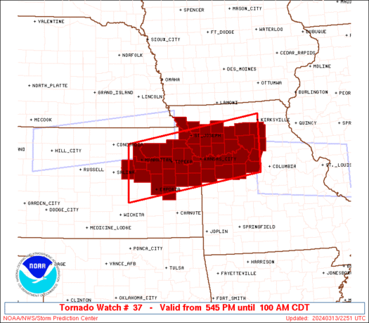
WW 37 TORNADO KS MO 132245Z - 140600Z
AXIS..55 STATUTE MILES NORTH AND SOUTH OF LINE..
35SW MHK/MANHATTAN KS/ - 60ESE CDJ/CHILLICOTHE MO/
..AVIATION COORDS.. 50NM N/S /25ESE SLN - 40S IRK/
HAIL SURFACE AND ALOFT..2.5 INCHES. WIND GUSTS..60 KNOTS.
MAX TOPS TO 450. MEAN STORM MOTION VECTOR 25035.
LAT...LON 39579713 40289254 38689254 37979713
THIS IS AN APPROXIMATION TO THE WATCH AREA. FOR A
COMPLETE DEPICTION OF THE WATCH SEE WOUS64 KWNS
FOR WOU7.
Watch 37 Status Report Messages:
STATUS REPORT #4 ON WW 37

VALID 140240Z - 140340Z

THE SEVERE WEATHER THREAT CONTINUES ACROSS THE ENTIRE WATCH AREA.

..BROYLES..03/14/24

ATTN...WFO...EAX...TOP...

&&

STATUS REPORT FOR WT 37

SEVERE WEATHER THREAT CONTINUES FOR THE FOLLOWING AREAS

KSC005-031-041-043-045-059-061-085-087-091-103-111-121-127-139-
149-161-177-197-209-140340-

KS
.    KANSAS COUNTIES INCLUDED ARE

ATCHISON	     COFFEY		 DICKINSON
DONIPHAN	     DOUGLAS		 FRANKLIN
GEARY		     JACKSON		 JEFFERSON
JOHNSON 	     LEAVENWORTH	 LYON
MIAMI		     MORRIS		 OSAGE
POTTAWATOMIE	     RILEY		 SHAWNEE
WABAUNSEE	     WYANDOTTE
$$


MOC003-021-025-033-037-041-047-049-053-061-063-087-089-095-101-
107-115-117-121-159-165-175-177-195-140340-

MO
.    MISSOURI COUNTIES INCLUDED ARE

ANDREW		     BUCHANAN		 CALDWELL
CARROLL 	     CASS		 CHARITON
CLAY		     CLINTON		 COOPER
DAVIESS 	     DEKALB		 HOLT
HOWARD		     JACKSON		 JOHNSON
LAFAYETTE	     LINN		 LIVINGSTON
MACON		     PETTIS		 PLATTE
RANDOLPH	     RAY		 SALINE
$$


THE WATCH STATUS MESSAGE IS FOR GUIDANCE PURPOSES ONLY.  PLEASE
REFER TO WATCH COUNTY NOTIFICATION STATEMENTS FOR OFFICIAL
INFORMATION ON COUNTIES...INDEPENDENT CITIES AND MARINE ZONES
CLEARED FROM SEVERE THUNDERSTORM AND TORNADO WATCHES.
$$

STATUS REPORT #3 ON WW 37

VALID 140215Z - 140340Z

THE SEVERE WEATHER THREAT CONTINUES ACROSS THE ENTIRE WATCH AREA.

..BROYLES..03/14/24

ATTN...WFO...EAX...TOP...

&&

STATUS REPORT FOR WT 37

SEVERE WEATHER THREAT CONTINUES FOR THE FOLLOWING AREAS

KSC005-031-041-043-045-059-061-085-087-091-103-111-121-127-139-
149-161-177-197-209-140340-

KS
.    KANSAS COUNTIES INCLUDED ARE

ATCHISON	     COFFEY		 DICKINSON
DONIPHAN	     DOUGLAS		 FRANKLIN
GEARY		     JACKSON		 JEFFERSON
JOHNSON 	     LEAVENWORTH	 LYON
MIAMI		     MORRIS		 OSAGE
POTTAWATOMIE	     RILEY		 SHAWNEE
WABAUNSEE	     WYANDOTTE
$$


MOC003-021-025-033-037-041-047-049-053-061-063-087-089-095-101-
107-115-117-121-159-165-175-177-195-140340-

MO
.    MISSOURI COUNTIES INCLUDED ARE

ANDREW		     BUCHANAN		 CALDWELL
CARROLL 	     CASS		 CHARITON
CLAY		     CLINTON		 COOPER
DAVIESS 	     DEKALB		 HOLT
HOWARD		     JACKSON		 JOHNSON
LAFAYETTE	     LINN		 LIVINGSTON
MACON		     PETTIS		 PLATTE
RANDOLPH	     RAY		 SALINE
$$


THE WATCH STATUS MESSAGE IS FOR GUIDANCE PURPOSES ONLY.  PLEASE
REFER TO WATCH COUNTY NOTIFICATION STATEMENTS FOR OFFICIAL
INFORMATION ON COUNTIES...INDEPENDENT CITIES AND MARINE ZONES
CLEARED FROM SEVERE THUNDERSTORM AND TORNADO WATCHES.
$$

STATUS REPORT #2 ON WW 37

VALID 140130Z - 140240Z

THE SEVERE WEATHER THREAT CONTINUES ACROSS THE ENTIRE WATCH AREA.

..BROYLES..03/14/24

ATTN...WFO...EAX...TOP...

&&

STATUS REPORT FOR WT 37

SEVERE WEATHER THREAT CONTINUES FOR THE FOLLOWING AREAS

KSC005-031-041-043-045-059-061-085-087-091-103-111-121-127-139-
149-161-177-197-209-140240-

KS
.    KANSAS COUNTIES INCLUDED ARE

ATCHISON	     COFFEY		 DICKINSON
DONIPHAN	     DOUGLAS		 FRANKLIN
GEARY		     JACKSON		 JEFFERSON
JOHNSON 	     LEAVENWORTH	 LYON
MIAMI		     MORRIS		 OSAGE
POTTAWATOMIE	     RILEY		 SHAWNEE
WABAUNSEE	     WYANDOTTE
$$


MOC003-021-025-033-037-041-047-049-053-061-063-087-089-095-101-
107-115-117-121-159-165-175-177-195-140240-

MO
.    MISSOURI COUNTIES INCLUDED ARE

ANDREW		     BUCHANAN		 CALDWELL
CARROLL 	     CASS		 CHARITON
CLAY		     CLINTON		 COOPER
DAVIESS 	     DEKALB		 HOLT
HOWARD		     JACKSON		 JOHNSON
LAFAYETTE	     LINN		 LIVINGSTON
MACON		     PETTIS		 PLATTE
RANDOLPH	     RAY		 SALINE
$$


THE WATCH STATUS MESSAGE IS FOR GUIDANCE PURPOSES ONLY.  PLEASE
REFER TO WATCH COUNTY NOTIFICATION STATEMENTS FOR OFFICIAL
INFORMATION ON COUNTIES...INDEPENDENT CITIES AND MARINE ZONES
CLEARED FROM SEVERE THUNDERSTORM AND TORNADO WATCHES.
$$

STATUS REPORT #1 ON WW 37

VALID 140025Z - 140140Z

THE SEVERE WEATHER THREAT CONTINUES ACROSS THE ENTIRE WATCH AREA.

..BROYLES..03/14/24

ATTN...WFO...EAX...TOP...

&&

STATUS REPORT FOR WT 37

SEVERE WEATHER THREAT CONTINUES FOR THE FOLLOWING AREAS

KSC005-031-041-043-045-059-061-085-087-091-103-111-121-127-139-
149-161-177-197-209-140140-

KS
.    KANSAS COUNTIES INCLUDED ARE

ATCHISON	     COFFEY		 DICKINSON
DONIPHAN	     DOUGLAS		 FRANKLIN
GEARY		     JACKSON		 JEFFERSON
JOHNSON 	     LEAVENWORTH	 LYON
MIAMI		     MORRIS		 OSAGE
POTTAWATOMIE	     RILEY		 SHAWNEE
WABAUNSEE	     WYANDOTTE
$$


MOC003-021-025-033-037-041-047-049-053-061-063-087-089-095-101-
107-115-117-121-159-165-175-177-195-140140-

MO
.    MISSOURI COUNTIES INCLUDED ARE

ANDREW		     BUCHANAN		 CALDWELL
CARROLL 	     CASS		 CHARITON
CLAY		     CLINTON		 COOPER
DAVIESS 	     DEKALB		 HOLT
HOWARD		     JACKSON		 JOHNSON
LAFAYETTE	     LINN		 LIVINGSTON
MACON		     PETTIS		 PLATTE
RANDOLPH	     RAY		 SALINE
$$


THE WATCH STATUS MESSAGE IS FOR GUIDANCE PURPOSES ONLY.  PLEASE
REFER TO WATCH COUNTY NOTIFICATION STATEMENTS FOR OFFICIAL
INFORMATION ON COUNTIES...INDEPENDENT CITIES AND MARINE ZONES
CLEARED FROM SEVERE THUNDERSTORM AND TORNADO WATCHES.
$$
Note:
Click for Complete Product Text.
Tornadoes
Probability of 2 or more tornadoes
|
Mod (40%)
|
Probability of 1 or more strong (EF2-EF5) tornadoes
|
Low (20%)
|
Wind
Probability of 10 or more severe wind events
|
Mod (60%)
|
Probability of 1 or more wind events > 65 knots
|
Low (20%)
|
Hail
Probability of 10 or more severe hail events
|
High (70%)
|
Probability of 1 or more hailstones > 2 inches
|
Mod (60%)
|
Combined Severe Hail/Wind
Probability of 6 or more combined severe hail/wind events
|
High (>95%)
|
For each watch, probabilities for particular events inside the watch
(listed above in each table) are determined by the issuing forecaster.
The "Low" category contains probability values ranging from less than 2%
to 20% (EF2-EF5 tornadoes), less than 5% to 20% (all other probabilities),
"Moderate" from 30% to 60%, and "High" from 70% to greater than 95%.
High values are bolded and lighter in color to provide awareness of
an increased threat for a particular event.


 @NWSSPC


