 Note:
The expiration time in the watch graphic is amended if the watch is
replaced, cancelled or extended.
Note:
Note:
The expiration time in the watch graphic is amended if the watch is
replaced, cancelled or extended.
Note: Click for
Watch Status Reports.
SEL1
URGENT - IMMEDIATE BROADCAST REQUESTED
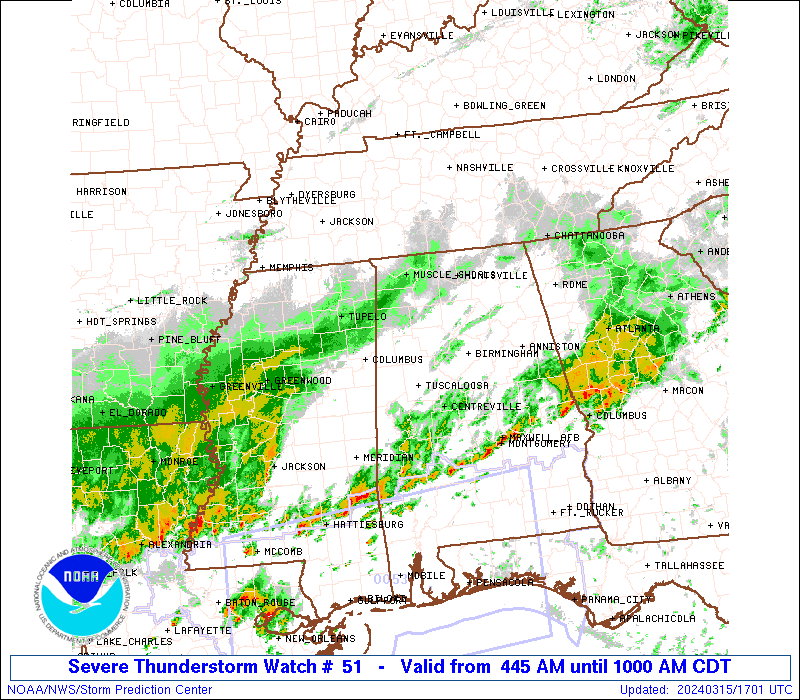
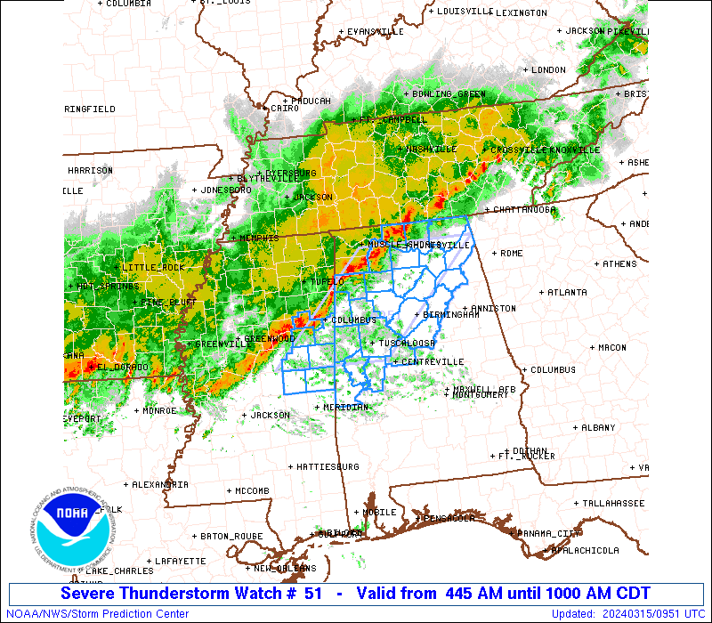
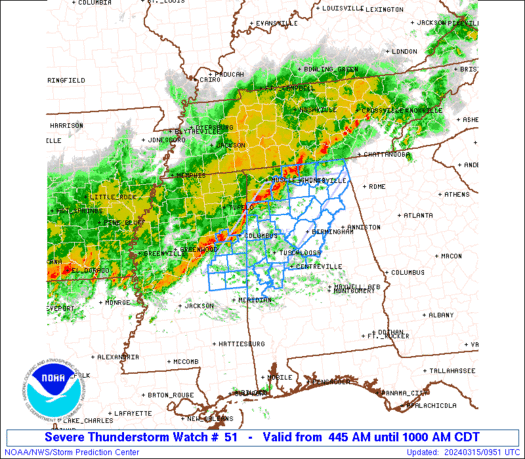
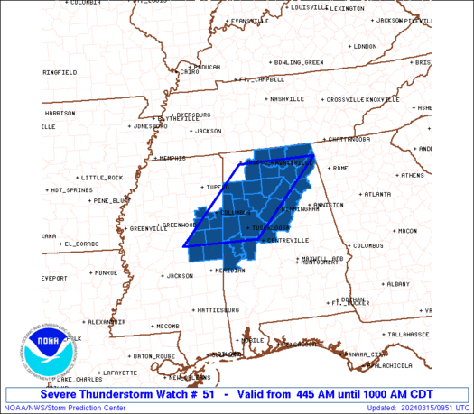
Severe Thunderstorm Watch Number 51
NWS Storm Prediction Center Norman OK
445 AM CDT Fri Mar 15 2024
The NWS Storm Prediction Center has issued a
* Severe Thunderstorm Watch for portions of
Northern and central Alabama
East central Mississippi
* Effective this Friday morning from 445 AM until 1000 AM CDT.
* Primary threats include...
Scattered damaging wind gusts to 70 mph possible
A tornado or two possible
SUMMARY...A squall line with embedded north-south segments will pose
a threat for damaging gusts of 60-70 mph, as well as a brief tornado
or two with embedded circulations.
The severe thunderstorm watch area is approximately along and 60
statute miles east and west of a line from 10 miles east northeast
of Huntsville AL to 50 miles west southwest of Tuscaloosa AL. For a
complete depiction of the watch see the associated watch outline
update (WOUS64 KWNS WOU1).
PRECAUTIONARY/PREPAREDNESS ACTIONS...
REMEMBER...A Severe Thunderstorm Watch means conditions are
favorable for severe thunderstorms in and close to the watch area.
Persons in these areas should be on the lookout for threatening
weather conditions and listen for later statements and possible
warnings. Severe thunderstorms can and occasionally do produce
tornadoes.
&&
AVIATION...A few severe thunderstorms with hail surface and aloft to
0.5 inches. Extreme turbulence and surface wind gusts to 60 knots. A
few cumulonimbi with maximum tops to 500. Mean storm motion vector
28035.
...Thompson
   SEL1

   URGENT - IMMEDIATE BROADCAST REQUESTED
   Severe Thunderstorm Watch Number 51
   NWS Storm Prediction Center Norman OK
   445 AM CDT Fri Mar 15 2024

   The NWS Storm Prediction Center has issued a

   * Severe Thunderstorm Watch for portions of
     Northern and central Alabama
     East central Mississippi

   * Effective this Friday morning from 445 AM until 1000 AM CDT.

   * Primary threats include...
     Scattered damaging wind gusts to 70 mph possible
     A tornado or two possible

   SUMMARY...A squall line with embedded north-south segments will pose
   a threat for damaging gusts of 60-70 mph, as well as a brief tornado
   or two with embedded circulations.

   The severe thunderstorm watch area is approximately along and 60
   statute miles east and west of a line from 10 miles east northeast
   of Huntsville AL to 50 miles west southwest of Tuscaloosa AL. For a
   complete depiction of the watch see the associated watch outline
   update (WOUS64 KWNS WOU1).

   PRECAUTIONARY/PREPAREDNESS ACTIONS...

   REMEMBER...A Severe Thunderstorm Watch means conditions are
   favorable for severe thunderstorms in and close to the watch area.
   Persons in these areas should be on the lookout for threatening
   weather conditions and listen for later statements and possible
   warnings. Severe thunderstorms can and occasionally do produce
   tornadoes.

   &&

   AVIATION...A few severe thunderstorms with hail surface and aloft to
   0.5 inches. Extreme turbulence and surface wind gusts to 60 knots. A
   few cumulonimbi with maximum tops to 500. Mean storm motion vector
   28035.

   ...Thompson
 Note:
The Aviation Watch (SAW) product is an approximation to the watch area.
The actual watch is depicted by the shaded areas.
Note:
The Aviation Watch (SAW) product is an approximation to the watch area.
The actual watch is depicted by the shaded areas.
   SAW1
   WW 51 SEVERE TSTM AL MS 150945Z - 151500Z
   AXIS..60 STATUTE MILES EAST AND WEST OF LINE..
   10ENE HSV/HUNTSVILLE AL/ - 50WSW TCL/TUSCALOOSA AL/
   ..AVIATION COORDS.. 50NM E/W /43E MSL - 33S IGB/
   HAIL SURFACE AND ALOFT..0.5 INCH. WIND GUSTS..60 KNOTS.
   MAX TOPS TO 500. MEAN STORM MOTION VECTOR 28035.

   LAT...LON 34708556 32938738 32938945 34708767

   THIS IS AN APPROXIMATION TO THE WATCH AREA.  FOR A
   COMPLETE DEPICTION OF THE WATCH SEE WOUS64 KWNS
   FOR WOU1.
Watch 51 Status Report Messages:
STATUS REPORT #2 ON WW 51

VALID 151225Z - 151340Z

SEVERE WEATHER THREAT CONTINUES RIGHT OF A LINE FROM 40 SE GWO TO
20 S CBM TO 20 W TCL TO 25 NW BHM TO 15 WNW GAD TO 10 W CHA.

..DEAN..03/15/24

ATTN...WFO...BMX...HUN...JAN...

&&

STATUS REPORT FOR WS 51

SEVERE WEATHER THREAT CONTINUES FOR THE FOLLOWING AREAS

ALC007-049-055-063-065-073-107-115-117-119-125-151340-

AL
.    ALABAMA COUNTIES INCLUDED ARE

BIBB		     DEKALB		 ETOWAH
GREENE		     HALE		 JEFFERSON
PICKENS 	     ST. CLAIR		 SHELBY
SUMTER		     TUSCALOOSA
$$


MSC069-099-103-159-151340-

MS
.    MISSISSIPPI COUNTIES INCLUDED ARE

KEMPER		     NESHOBA		 NOXUBEE
WINSTON
$$


THE WATCH STATUS MESSAGE IS FOR GUIDANCE PURPOSES ONLY.  PLEASE
REFER TO WATCH COUNTY NOTIFICATION STATEMENTS FOR OFFICIAL
INFORMATION ON COUNTIES...INDEPENDENT CITIES AND MARINE ZONES
CLEARED FROM SEVERE THUNDERSTORM AND TORNADO WATCHES.
$$

STATUS REPORT #1 ON WW 51

VALID 151130Z - 151240Z

SEVERE WEATHER THREAT CONTINUES RIGHT OF A LINE FROM 45 ESE GWO
TO 30 NW TCL TO 45 S MSL TO 35 SSW HSV TO 40 W CHA.

..DEAN..03/15/24

ATTN...WFO...BMX...HUN...JAN...

&&

STATUS REPORT FOR WS 51

SEVERE WEATHER THREAT CONTINUES FOR THE FOLLOWING AREAS

ALC007-009-049-055-057-063-065-071-073-095-107-115-117-119-125-
127-151240-

AL
.    ALABAMA COUNTIES INCLUDED ARE

BIBB		     BLOUNT		 DEKALB
ETOWAH		     FAYETTE		 GREENE
HALE		     JACKSON		 JEFFERSON
MARSHALL	     PICKENS		 ST. CLAIR
SHELBY		     SUMTER		 TUSCALOOSA
WALKER
$$


MSC069-099-103-159-151240-

MS
.    MISSISSIPPI COUNTIES INCLUDED ARE

KEMPER		     NESHOBA		 NOXUBEE
WINSTON
$$


THE WATCH STATUS MESSAGE IS FOR GUIDANCE PURPOSES ONLY.  PLEASE
REFER TO WATCH COUNTY NOTIFICATION STATEMENTS FOR OFFICIAL
INFORMATION ON COUNTIES...INDEPENDENT CITIES AND MARINE ZONES
CLEARED FROM SEVERE THUNDERSTORM AND TORNADO WATCHES.
$$
Note:
Click for Complete Product Text.
Tornadoes
Probability of 2 or more tornadoes
|
Low (20%)
|
Probability of 1 or more strong (EF2-EF5) tornadoes
|
Low (5%)
|
Wind
Probability of 10 or more severe wind events
|
Mod (40%)
|
Probability of 1 or more wind events > 65 knots
|
Low (20%)
|
Hail
Probability of 10 or more severe hail events
|
Low (10%)
|
Probability of 1 or more hailstones > 2 inches
|
Low (10%)
|
Combined Severe Hail/Wind
Probability of 6 or more combined severe hail/wind events
|
Mod (60%)
|
For each watch, probabilities for particular events inside the watch
(listed above in each table) are determined by the issuing forecaster.
The "Low" category contains probability values ranging from less than 2%
to 20% (EF2-EF5 tornadoes), less than 5% to 20% (all other probabilities),
"Moderate" from 30% to 60%, and "High" from 70% to greater than 95%.
High values are bolded and lighter in color to provide awareness of
an increased threat for a particular event.


 @NWSSPC