 Note:
The expiration time in the watch graphic is amended if the watch is
replaced, cancelled or extended.
Note:
Note:
The expiration time in the watch graphic is amended if the watch is
replaced, cancelled or extended.
Note: Click for
Watch Status Reports.
SEL5
URGENT - IMMEDIATE BROADCAST REQUESTED
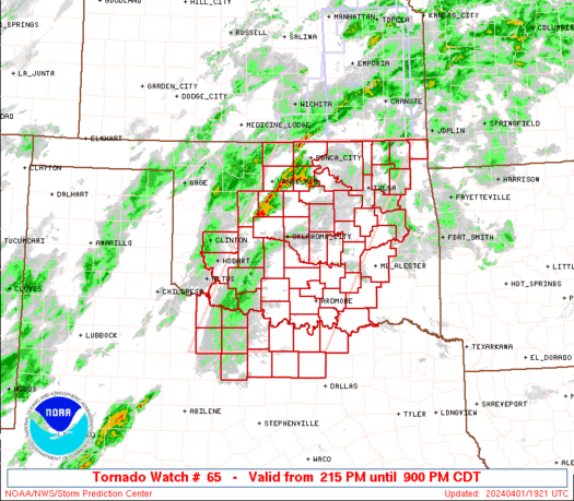
Tornado Watch Number 65
NWS Storm Prediction Center Norman OK
215 PM CDT Mon Apr 1 2024
The NWS Storm Prediction Center has issued a
* Tornado Watch for portions of
Southern, central and northeast Oklahoma
Northwest Texas
* Effective this Monday afternoon and evening from 215 PM until
900 PM CDT.
* Primary threats include...
A few tornadoes likely with a couple intense tornadoes possible
Widespread large hail and scattered very large hail events to 4
inches in diameter likely
Scattered damaging winds likely with isolated significant gusts
to 80 mph possible
SUMMARY...Scattered supercell development is expected this afternoon
through this evening from central/southwest Oklahoma into northwest
Texas. The storms will move east-northeastward and intensify by
late afternoon, with the potential to produce very large hail (3-4
inches in diameter). With time into this evening, there will be an
increase in the threat for tornadoes (up to EF2) with persistent
supercells, as well as damaging winds (60-80 mph) once upscale
growth into clusters occurs.
The tornado watch area is approximately along and 80 statute miles
east and west of a line from 25 miles northwest of Bartlesville OK
to 40 miles south southeast of Wichita Falls TX. For a complete
depiction of the watch see the associated watch outline update
(WOUS64 KWNS WOU5).
PRECAUTIONARY/PREPAREDNESS ACTIONS...
REMEMBER...A Tornado Watch means conditions are favorable for
tornadoes and severe thunderstorms in and close to the watch
area. Persons in these areas should be on the lookout for
threatening weather conditions and listen for later statements
and possible warnings.
&&
OTHER WATCH INFORMATION...CONTINUE...WW 64...
AVIATION...Tornadoes and a few severe thunderstorms with hail
surface and aloft to 4 inches. Extreme turbulence and surface wind
gusts to 70 knots. A few cumulonimbi with maximum tops to 550. Mean
storm motion vector 24040.
...Thompson

   SEL5

   URGENT - IMMEDIATE BROADCAST REQUESTED
   Tornado Watch Number 65
   NWS Storm Prediction Center Norman OK
   215 PM CDT Mon Apr 1 2024

   The NWS Storm Prediction Center has issued a

   * Tornado Watch for portions of
     Southern, central and northeast Oklahoma
     Northwest Texas

   * Effective this Monday afternoon and evening from 215 PM until
     900 PM CDT.

   * Primary threats include...
     A few tornadoes likely with a couple intense tornadoes possible
     Widespread large hail and scattered very large hail events to 4
       inches in diameter likely
     Scattered damaging winds likely with isolated significant gusts
       to 80 mph possible

   SUMMARY...Scattered supercell development is expected this afternoon
   through this evening from central/southwest Oklahoma into northwest
   Texas.  The storms will move east-northeastward and intensify by
   late afternoon, with the potential to produce very large hail (3-4
   inches in diameter).  With time into this evening, there will be an
   increase in the threat for tornadoes (up to EF2) with persistent
   supercells, as well as damaging winds (60-80 mph) once upscale
   growth into clusters occurs.

   The tornado watch area is approximately along and 80 statute miles
   east and west of a line from 25 miles northwest of Bartlesville OK
   to 40 miles south southeast of Wichita Falls TX. For a complete
   depiction of the watch see the associated watch outline update
   (WOUS64 KWNS WOU5).

   PRECAUTIONARY/PREPAREDNESS ACTIONS...

   REMEMBER...A Tornado Watch means conditions are favorable for
   tornadoes and severe thunderstorms in and close to the watch
   area. Persons in these areas should be on the lookout for
   threatening weather conditions and listen for later statements
   and possible warnings.

   &&

   OTHER WATCH INFORMATION...CONTINUE...WW 64...

   AVIATION...Tornadoes and a few severe thunderstorms with hail
   surface and aloft to 4 inches. Extreme turbulence and surface wind
   gusts to 70 knots. A few cumulonimbi with maximum tops to 550. Mean
   storm motion vector 24040.

   ...Thompson
 Note:
The Aviation Watch (SAW) product is an approximation to the watch area.
The actual watch is depicted by the shaded areas.
Note:
The Aviation Watch (SAW) product is an approximation to the watch area.
The actual watch is depicted by the shaded areas.
SAW5
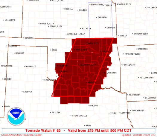
WW 65 TORNADO OK TX 011915Z - 020200Z
AXIS..80 STATUTE MILES EAST AND WEST OF LINE..
25NW BVO/BARTLESVILLE OK/ - 40SSE SPS/WICHITA FALLS TX/
..AVIATION COORDS.. 70NM E/W /55W OSW - 38SSE SPS/
HAIL SURFACE AND ALOFT..4 INCHES. WIND GUSTS..70 KNOTS.
MAX TOPS TO 550. MEAN STORM MOTION VECTOR 24040.
LAT...LON 37029489 33439685 33439962 37029779
THIS IS AN APPROXIMATION TO THE WATCH AREA. FOR A
COMPLETE DEPICTION OF THE WATCH SEE WOUS64 KWNS
FOR WOU5.
Watch 65 Status Report Messages:
STATUS REPORT #4 ON WW 65

VALID 020040Z - 020140Z

SEVERE WEATHER THREAT CONTINUES RIGHT OF A LINE FROM 40 WSW END
TO 20 E END TO 40 NE PNC.

..WEINMAN..04/02/24

ATTN...WFO...OUN...TSA...FWD...

&&

STATUS REPORT FOR WT 65

SEVERE WEATHER THREAT CONTINUES FOR THE FOLLOWING AREAS

OKC005-011-013-015-017-019-027-029-031-033-035-037-047-049-051-
063-067-069-071-073-075-081-083-085-087-091-095-097-099-101-103-
105-107-109-111-113-115-117-119-121-123-125-131-133-137-141-143-
145-147-149-020140-

OK
.    OKLAHOMA COUNTIES INCLUDED ARE

ATOKA		     BLAINE		 BRYAN
CADDO		     CANADIAN		 CARTER
CLEVELAND	     COAL		 COMANCHE
COTTON		     CRAIG		 CREEK
GARFIELD	     GARVIN		 GRADY
HUGHES		     JEFFERSON		 JOHNSTON
KAY		     KINGFISHER 	 KIOWA
LINCOLN 	     LOGAN		 LOVE
MCCLAIN 	     MCINTOSH		 MARSHALL
MAYES		     MURRAY		 MUSKOGEE
NOBLE		     NOWATA		 OKFUSKEE
OKLAHOMA	     OKMULGEE		 OSAGE
OTTAWA		     PAWNEE		 PAYNE
PITTSBURG	     PONTOTOC		 POTTAWATOMIE
ROGERS		     SEMINOLE		 STEPHENS
TILLMAN 	     TULSA		 WAGONER
WASHINGTON	     WASHITA
$$


TXC009-023-077-097-121-181-237-337-485-487-497-503-020140-

TX
.    TEXAS COUNTIES INCLUDED ARE

ARCHER		     BAYLOR		 CLAY
COOKE		     DENTON		 GRAYSON
JACK		     MONTAGUE		 WICHITA
WILBARGER	     WISE		 YOUNG
$$


THE WATCH STATUS MESSAGE IS FOR GUIDANCE PURPOSES ONLY.  PLEASE
REFER TO WATCH COUNTY NOTIFICATION STATEMENTS FOR OFFICIAL
INFORMATION ON COUNTIES...INDEPENDENT CITIES AND MARINE ZONES
CLEARED FROM SEVERE THUNDERSTORM AND TORNADO WATCHES.
$$

STATUS REPORT #3 ON WW 65

VALID 012345Z - 020040Z

THE SEVERE WEATHER THREAT CONTINUES ACROSS THE ENTIRE WATCH AREA.

FOR ADDITIONAL INFORMATION SEE MESOSCALE DISCUSSION 328

..WEINMAN..04/01/24

ATTN...WFO...OUN...TSA...FWD...

&&

STATUS REPORT FOR WT 65

SEVERE WEATHER THREAT CONTINUES FOR THE FOLLOWING AREAS

OKC005-011-013-015-017-019-027-029-031-033-035-037-047-049-051-
053-063-067-069-071-073-075-081-083-085-087-091-095-097-099-101-
103-105-107-109-111-113-115-117-119-121-123-125-131-133-137-141-
143-145-147-149-020040-

OK
.    OKLAHOMA COUNTIES INCLUDED ARE

ATOKA		     BLAINE		 BRYAN
CADDO		     CANADIAN		 CARTER
CLEVELAND	     COAL		 COMANCHE
COTTON		     CRAIG		 CREEK
GARFIELD	     GARVIN		 GRADY
GRANT		     HUGHES		 JEFFERSON
JOHNSTON	     KAY		 KINGFISHER
KIOWA		     LINCOLN		 LOGAN
LOVE		     MCCLAIN		 MCINTOSH
MARSHALL	     MAYES		 MURRAY
MUSKOGEE	     NOBLE		 NOWATA
OKFUSKEE	     OKLAHOMA		 OKMULGEE
OSAGE		     OTTAWA		 PAWNEE
PAYNE		     PITTSBURG		 PONTOTOC
POTTAWATOMIE	     ROGERS		 SEMINOLE
STEPHENS	     TILLMAN		 TULSA
WAGONER 	     WASHINGTON 	 WASHITA
$$


TXC009-023-077-097-121-181-237-337-485-487-497-503-020040-

TX
.    TEXAS COUNTIES INCLUDED ARE

ARCHER		     BAYLOR		 CLAY
COOKE		     DENTON		 GRAYSON
JACK		     MONTAGUE		 WICHITA
WILBARGER	     WISE		 YOUNG
$$


THE WATCH STATUS MESSAGE IS FOR GUIDANCE PURPOSES ONLY.  PLEASE
REFER TO WATCH COUNTY NOTIFICATION STATEMENTS FOR OFFICIAL
INFORMATION ON COUNTIES...INDEPENDENT CITIES AND MARINE ZONES
CLEARED FROM SEVERE THUNDERSTORM AND TORNADO WATCHES.
$$

STATUS REPORT #2 ON WW 65

VALID 012245Z - 012340Z

THE SEVERE WEATHER THREAT CONTINUES ACROSS THE ENTIRE WATCH AREA.

..WEINMAN..04/01/24

ATTN...WFO...OUN...TSA...FWD...

&&

STATUS REPORT FOR WT 65

SEVERE WEATHER THREAT CONTINUES FOR THE FOLLOWING AREAS

OKC005-011-013-015-017-019-027-029-031-033-035-037-047-049-051-
053-063-067-069-071-073-075-081-083-085-087-091-095-097-099-101-
103-105-107-109-111-113-115-117-119-121-123-125-131-133-137-141-
143-145-147-149-012340-

OK
.    OKLAHOMA COUNTIES INCLUDED ARE

ATOKA		     BLAINE		 BRYAN
CADDO		     CANADIAN		 CARTER
CLEVELAND	     COAL		 COMANCHE
COTTON		     CRAIG		 CREEK
GARFIELD	     GARVIN		 GRADY
GRANT		     HUGHES		 JEFFERSON
JOHNSTON	     KAY		 KINGFISHER
KIOWA		     LINCOLN		 LOGAN
LOVE		     MCCLAIN		 MCINTOSH
MARSHALL	     MAYES		 MURRAY
MUSKOGEE	     NOBLE		 NOWATA
OKFUSKEE	     OKLAHOMA		 OKMULGEE
OSAGE		     OTTAWA		 PAWNEE
PAYNE		     PITTSBURG		 PONTOTOC
POTTAWATOMIE	     ROGERS		 SEMINOLE
STEPHENS	     TILLMAN		 TULSA
WAGONER 	     WASHINGTON 	 WASHITA
$$


TXC009-023-077-097-121-181-237-337-485-487-497-503-012340-

TX
.    TEXAS COUNTIES INCLUDED ARE

ARCHER		     BAYLOR		 CLAY
COOKE		     DENTON		 GRAYSON
JACK		     MONTAGUE		 WICHITA
WILBARGER	     WISE		 YOUNG
$$


THE WATCH STATUS MESSAGE IS FOR GUIDANCE PURPOSES ONLY.  PLEASE
REFER TO WATCH COUNTY NOTIFICATION STATEMENTS FOR OFFICIAL
INFORMATION ON COUNTIES...INDEPENDENT CITIES AND MARINE ZONES
CLEARED FROM SEVERE THUNDERSTORM AND TORNADO WATCHES.
$$

STATUS REPORT #1 ON WW 65

VALID 012150Z - 012240Z

THE SEVERE WEATHER THREAT CONTINUES ACROSS THE ENTIRE WATCH AREA.

..WEINMAN..04/01/24

ATTN...WFO...OUN...TSA...FWD...

&&

STATUS REPORT FOR WT 65

SEVERE WEATHER THREAT CONTINUES FOR THE FOLLOWING AREAS

OKC005-011-013-015-017-019-027-029-031-033-035-037-047-049-051-
053-063-067-069-071-073-075-081-083-085-087-091-095-097-099-101-
103-105-107-109-111-113-115-117-119-121-123-125-131-133-137-141-
143-145-147-149-012240-

OK
.    OKLAHOMA COUNTIES INCLUDED ARE

ATOKA		     BLAINE		 BRYAN
CADDO		     CANADIAN		 CARTER
CLEVELAND	     COAL		 COMANCHE
COTTON		     CRAIG		 CREEK
GARFIELD	     GARVIN		 GRADY
GRANT		     HUGHES		 JEFFERSON
JOHNSTON	     KAY		 KINGFISHER
KIOWA		     LINCOLN		 LOGAN
LOVE		     MCCLAIN		 MCINTOSH
MARSHALL	     MAYES		 MURRAY
MUSKOGEE	     NOBLE		 NOWATA
OKFUSKEE	     OKLAHOMA		 OKMULGEE
OSAGE		     OTTAWA		 PAWNEE
PAYNE		     PITTSBURG		 PONTOTOC
POTTAWATOMIE	     ROGERS		 SEMINOLE
STEPHENS	     TILLMAN		 TULSA
WAGONER 	     WASHINGTON 	 WASHITA
$$


TXC009-023-077-097-121-181-237-337-485-487-497-503-012240-

TX
.    TEXAS COUNTIES INCLUDED ARE

ARCHER		     BAYLOR		 CLAY
COOKE		     DENTON		 GRAYSON
JACK		     MONTAGUE		 WICHITA
WILBARGER	     WISE		 YOUNG
$$


THE WATCH STATUS MESSAGE IS FOR GUIDANCE PURPOSES ONLY.  PLEASE
REFER TO WATCH COUNTY NOTIFICATION STATEMENTS FOR OFFICIAL
INFORMATION ON COUNTIES...INDEPENDENT CITIES AND MARINE ZONES
CLEARED FROM SEVERE THUNDERSTORM AND TORNADO WATCHES.
$$
Note:
Click for Complete Product Text.
Tornadoes
Probability of 2 or more tornadoes
|
Mod (60%)
|
Probability of 1 or more strong (EF2-EF5) tornadoes
|
Mod (30%)
|
Wind
Probability of 10 or more severe wind events
|
Mod (60%)
|
Probability of 1 or more wind events > 65 knots
|
Mod (30%)
|
Hail
Probability of 10 or more severe hail events
|
High (90%)
|
Probability of 1 or more hailstones > 2 inches
|
High (90%)
|
Combined Severe Hail/Wind
Probability of 6 or more combined severe hail/wind events
|
High (>95%)
|
For each watch, probabilities for particular events inside the watch
(listed above in each table) are determined by the issuing forecaster.
The "Low" category contains probability values ranging from less than 2%
to 20% (EF2-EF5 tornadoes), less than 5% to 20% (all other probabilities),
"Moderate" from 30% to 60%, and "High" from 70% to greater than 95%.
High values are bolded and lighter in color to provide awareness of
an increased threat for a particular event.


 @NWSSPC


