|
Storm Prediction Center WCM Page
Intro | State Summaries | U.S. Annual Tornado Maps | 2016 Preliminary Reports to Date
Monthly Tornadoes Since 1950 | Bi-monthly Tornadoes by ENSO Phase Strength
Watch Frequency Maps | 20y Annual Average Watches by County | SPC AWIPS Products | Data | SVR GIS |
| Warning Coordination Meteorologist's Introduction |
|---|
Welcome to the WCM Page for the SPC. This page has charts of the latest preliminary severe storm reports, annual summaries, and links to comma-separated-value (csv) data files from the SPC severe weather database back to 1950. As time allows, this page may occasionally serve as a place for preliminary severe weather event assessments.
| 2015 Total Severe Weather Reports |
|---|
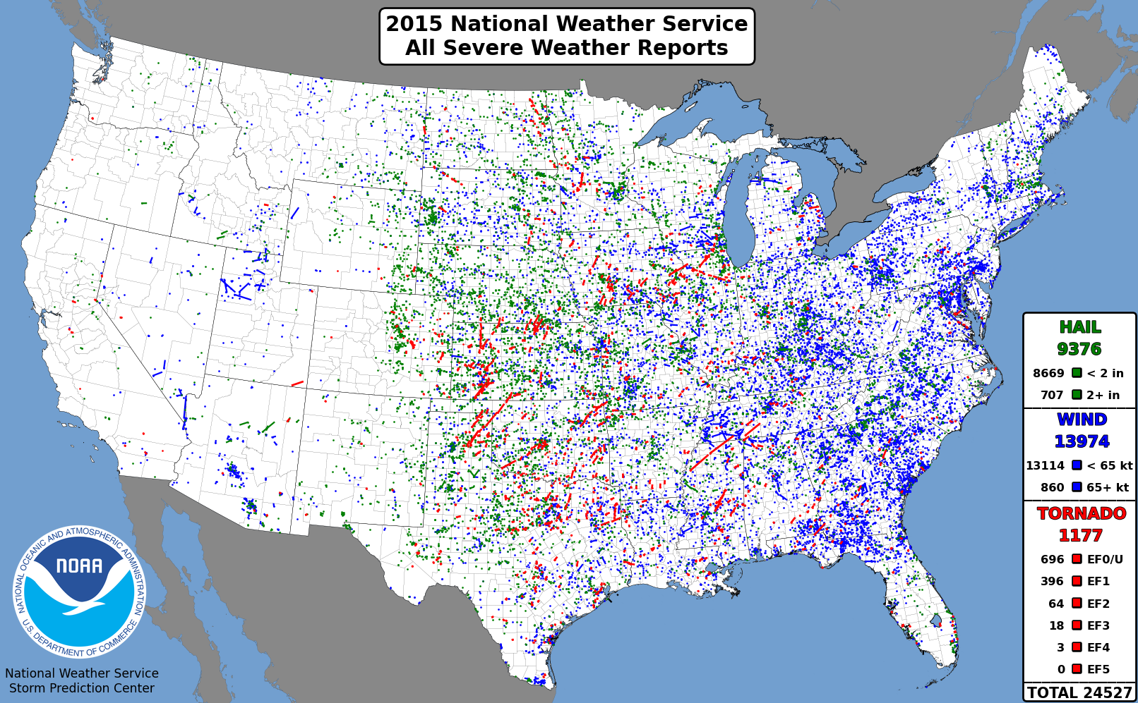
A map of all tornado (red), hail (green), and thunderstorm wind gust (blue) reports from NWS offices in 2015.
| | Cool Season Watch Days and El Niño Southern Oscillation (ENSO) Phase |
|---|
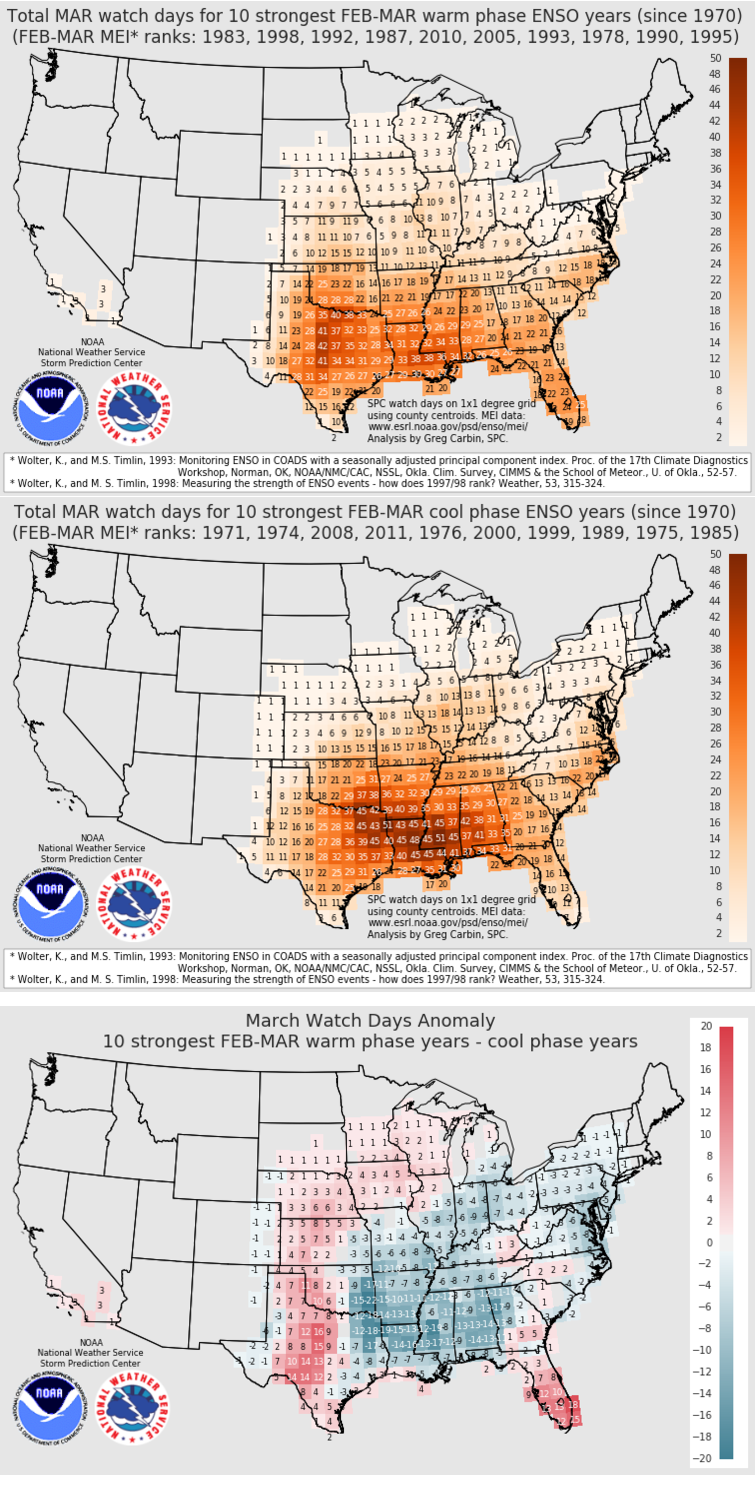
With strong El Niño (ENSO warm phase) conditions continuing into the winter months, here's an analysis of how those conditions may influence the number of watch days in December.
The ENSO phase strength was ranked using the Multivariate ENSO Index, or MEI.
The years with the 10 warmest (El Niño) and 10 coldest (La Niña) phases for the December to January time frame, back to 1970, were used to select the total* January watch days within each phase. (*Divide grid cell numbers by 10 to arrive at monthly mean watch days in each phase).
The top map shows the total watch days in the ten Januarys corresponding to the most pronounced El Niño conditions during December-January.
The middle map shows the total watch days for the ten Januarys with most pronounced La Niña conditions during December-January.
The bottom map shows the difference in total watch days between the strongest El Niño months and the strongest La Niña months.
The total watch day summary maps for December, January, February, April, and May also reveal how ENSO phase can influence severe weather potential during the cool season and early warm season.
Lastest information on MEI: http://www.esrl.noaa.gov/psd/enso/mei/.
Lastest on ENSO from CPC: http://www.cpc.ncep.noaa.gov/products/analysis_monitoring/enso_advisory/.
| | SPC WCM Page Content Archive |
|---|
2016
Outlook Forecasts for February 2, 2016
2015
Probability of a Tornado Watch during Week of Christmas
July 17-18, 2015 Radar/Wind Gust Summary
July 17-18, 2015 Radar/Wind Gust Summary
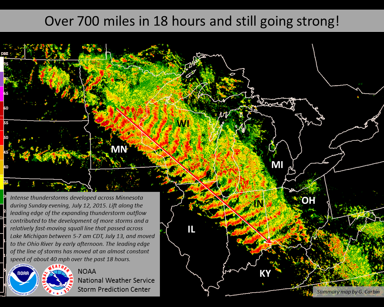
July 12-13, 2015 Radar Composite
A look at May 2015 Watch Anomalies
April 2013, 2014, 2015 Radar-based hail maps
March 2013, 2014, 2015 Radar-based hail maps
No March 2015 Watches through the 23rd
Longest Spans Between Watches
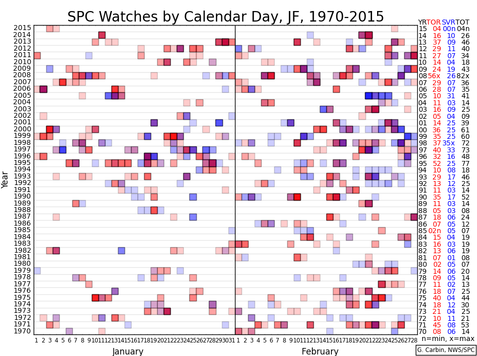
JF Watch Counts 1970-2015
2014
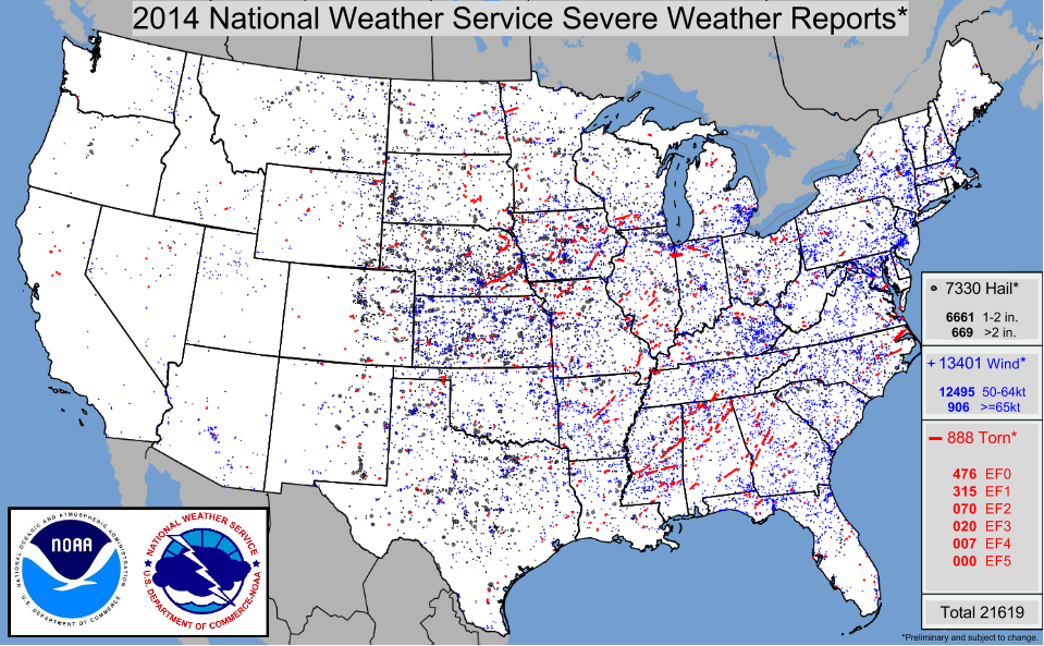
All storm reports across the continental U.S. in 2014
2014 Tornadoes and State Departures through October
Watch counts by month/type (through early September)
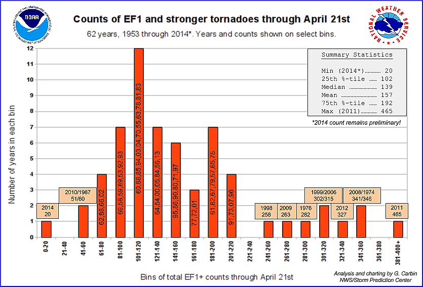
Histogram of tornado counts through April 21
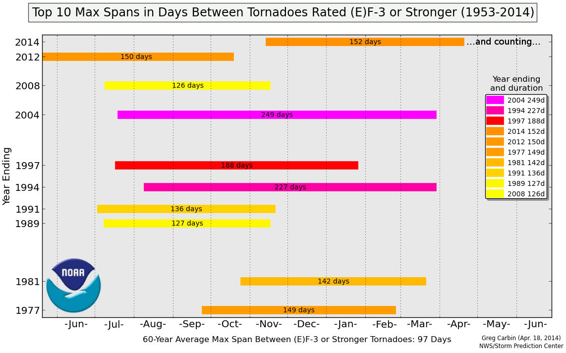
Spans without (E)F3-rated tornadoes
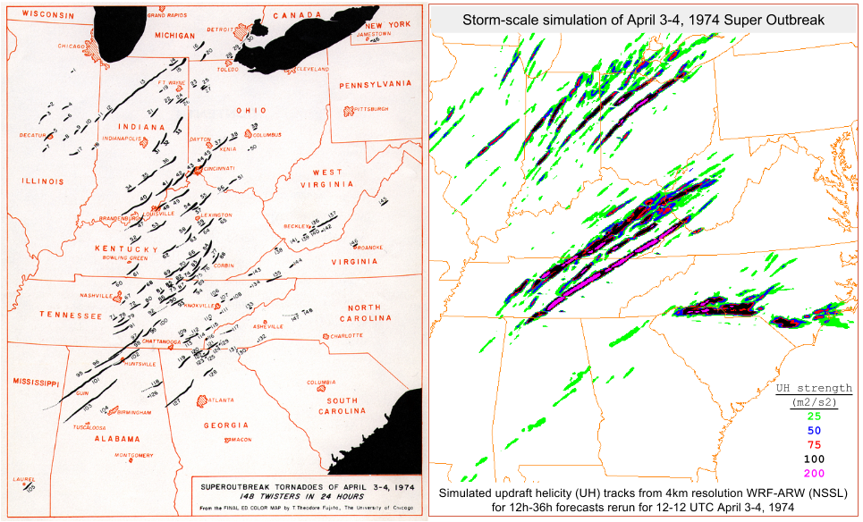
A look back at April 3-4, '74 with high resolution model
Analysis of partial season watch counts (pdf)
Midwest Derecho Event(s) of June 30, 2014
ND/MN Derecho of July 21-22, 2014
U.S. Tornado Counts thru May (1953-3014)
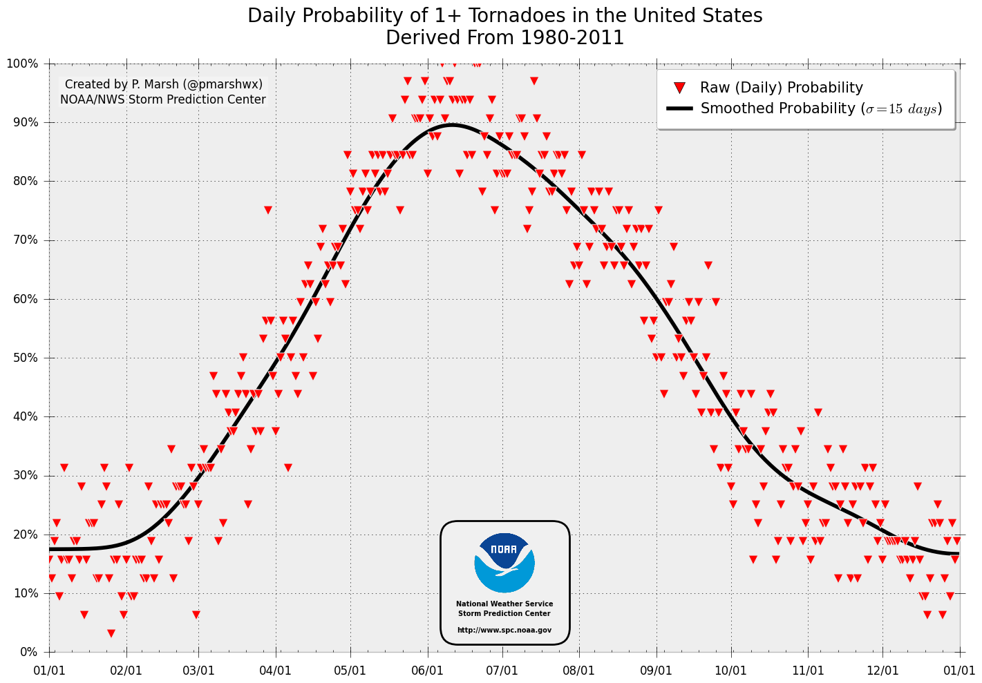
Daily Tornado Probability Curve
De-trended U.S. tornado counts through Nov.
2013
2013 Tornadoes by EF-scale Map
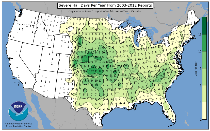
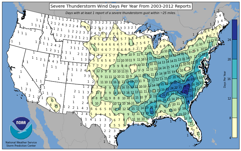
| | Severe Weather Reports Per Year (2003-2012) |
|---|
These maps were created by gridding the total number of daily severe weather reports (Midnight to 11:59pm CDT) over the 10-year period from
2003 through 2012 on a 80km grid. The resulting grid numbers are then divided by 10 and smoothed to arrive at the annual average number of
days with a report of severe weather based on official NWS Storm Data records. The 80km grid-point value corresponds to the number of events within
25 miles of a point. While the resulting maps generally match our understanding of severe weather climatology, there are a few exceptions
that come about as a result of how the severe weather event is quantified. Even through the data are smoothed, severe weather reports cluster
around population centers. This can be seen on the "any" or "all" severe weather map in the upper left. Maximum values show up around Charlotte,
NC, Huntsville, AL, Jackson, MS, Springfield, MO, and Dallas, TX. These are locations where more severe weather is reported because more people
live in those areas. The hail reports used to generate the hail frequency map are from reports of hail 1 inch or greater in diameter. Large hail
reports are most common from Rapid City, SD to Denver, CO, Dodge City, KS, and Springfield, MO. The wind report map perhaps poses the greatest
challenge in terms of representing where a greater severe thunderstorm wind threat may exist. The majority of severe thunderstorm wind reports
are verified by falling trees *not* by observed wind gusts of 50 knots or greater. Thus, there is a distinct tendency for severe
thunderstorm winds to be reported in areas with more trees. Recent peer-reviewed studies have compared the severe weather reports used to make
these maps with automated observations (for wind), and radar data (for hail). These studies have found that greater concentrations/frequencies
of severe hail (based on radar) and 50kt or greater severe thunderstorm wind gusts (based on automated observations) are more likely to occur
over parts of the Great Plains and Midwest than what might be indicated in the maps shown here. (Click each map for full resolution version.)
References:
An Objective High-Resolution Hail Climatology of the Contiguous United States
John L. Cintineo, Travis M. Smith, Valliappa Lakshmanan, Harold E. Brooks, Kiel L. Ortega
Weather and Forecasting
Volume 27, Issue 5 (October 2012) pp. 1235-1248
Measured Severe Convective Wind Climatology and Associated Convective Modes of Thunderstorms in the Contiguous United States, 2003-09
Bryan T. Smith, Tomas E. Castellanos, Andrew C. Winters, Corey M. Mead, Andrew R. Dean, Richard L. Thompson
Weather and Forecasting (Also here.)
Volume 28, Issue 1 (February 2013) pp. 229-236
| | Monthly Tornadoes by State |
|---|
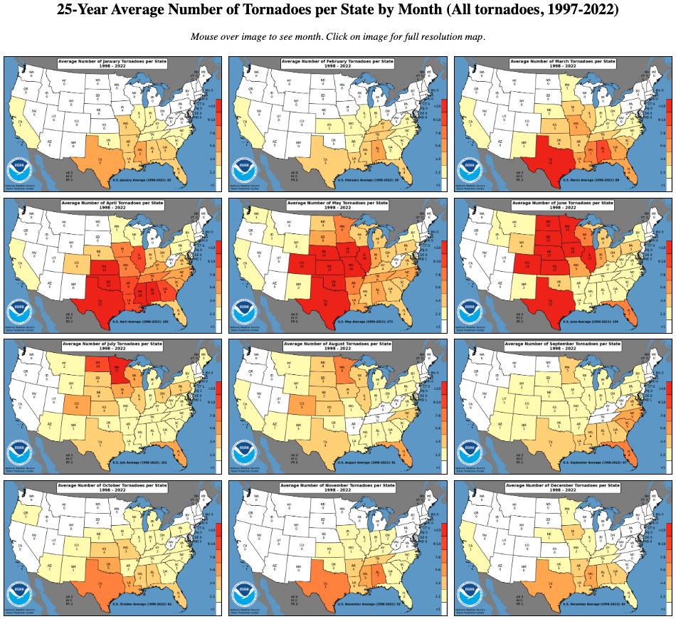
(Click on the maps to go to the maps page.)
| | Annual Tornado Maps (1952-2011) |
|---|
(Click on the maps to go to the Annual Tornado Maps page.)
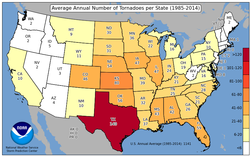
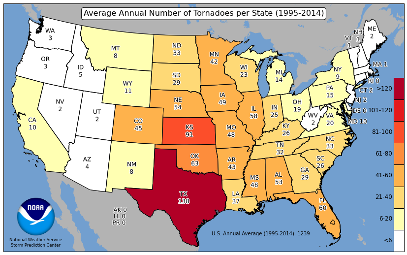
| | Annual Averages: Tornadoes by State |
|---|
|
| | Annual Averages: Tornado Fatalities by State |
|---|
|
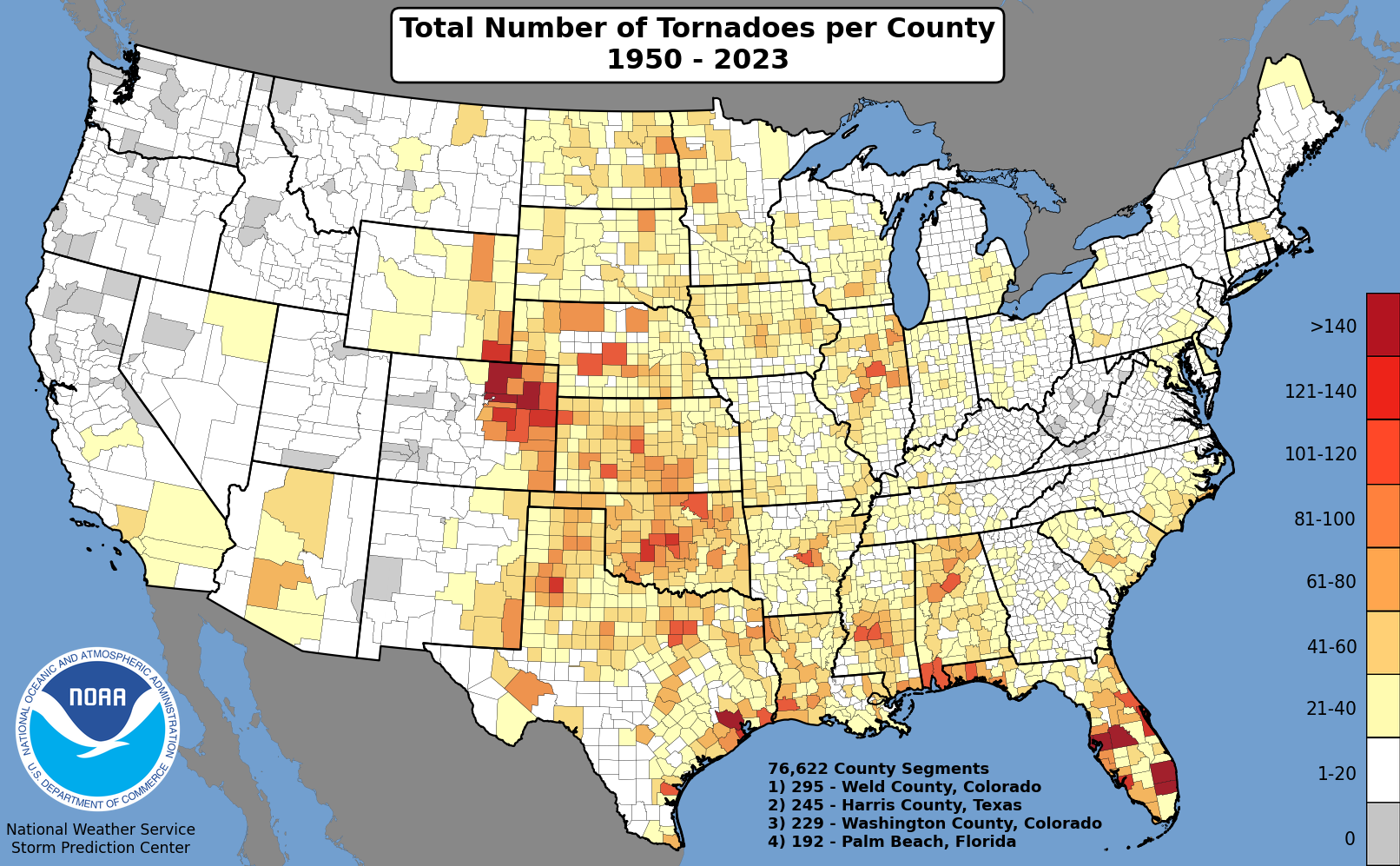
| | Other U.S. Tornado Summaries |
|---|
|
| | U.S. Monthly Tornado Counts, 1950-2010 |
|---|
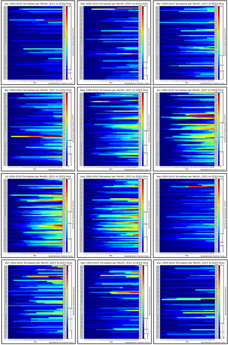
Monthly tornado sums (excluding (E)F0 tornadoes) for each month, 1950-2010.
(Click to go to calendar page.)
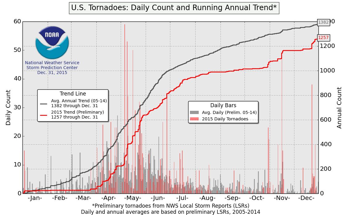
| | Daily Counts and Annual Running Trend (Updated Frequently) |
|---|
|
Mouse over or click for full image --->
Tornado Reports |
Hail Reports |
Wind Reports
|
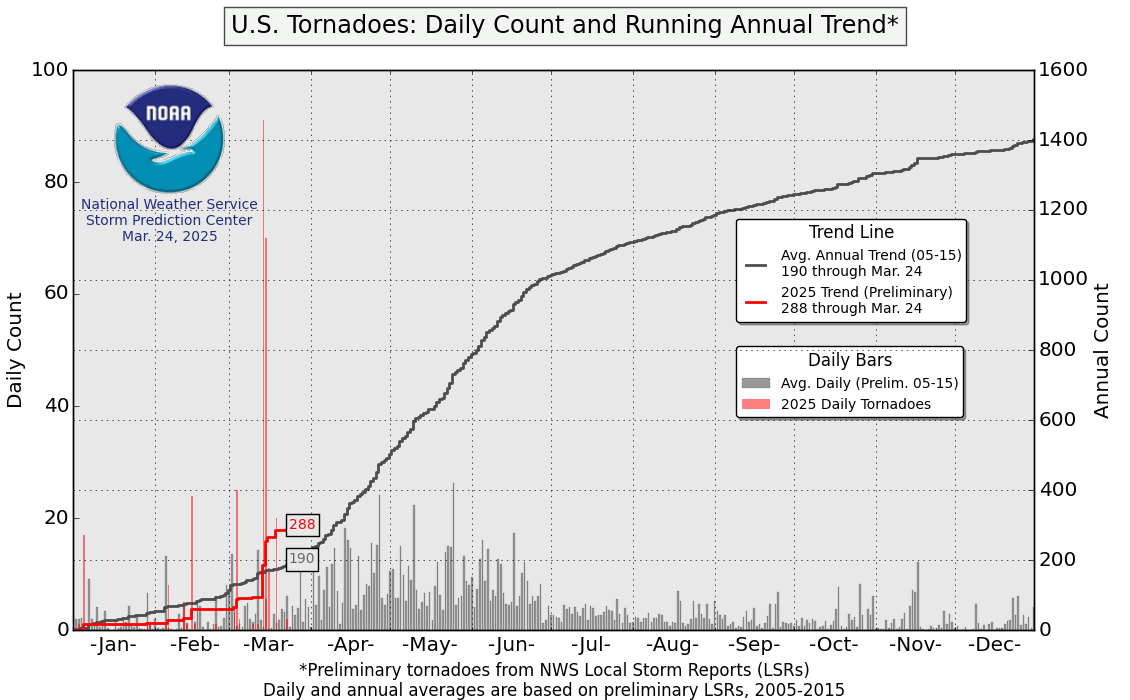
|
End of year charts for 2015: Tornadoes, Hail, and Wind.
End of year charts for 2014: Tornadoes, Hail, and Wind.
End of year charts for 2013: Tornadoes, Hail, and Wind.
End of year charts for 2012: Tornadoes, Hail, and Wind.
End of year charts for 2011: Tornadoes, Hail, and Wind.
|
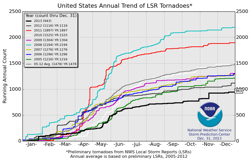
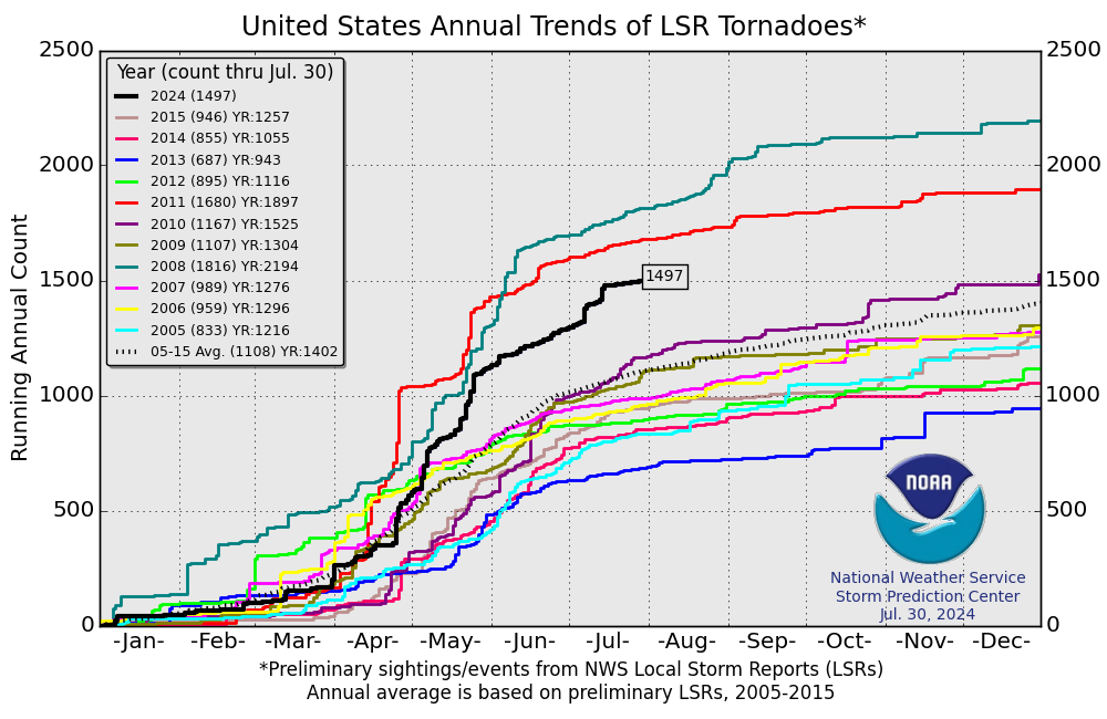 Plot of the annual running total of U.S. tornadoes. (Click on image for a full resolution version.)
End of year chart for 2015
End of year chart for 2014
End of year chart for 2013
End of year chart for 2012
End of year chart for 2011
|
 Plot of the annual running total of tornado reports compared to inflation adjusted values.
(Click on graph for a full description.)
End of year chart for 2015
End of year chart for 2014
End of year chart for 2013
End of year chart for 2012
End of year chart for 2011
|
| ENSO Strength and Bi-monthly U.S. Tornadoes since 1950
(Click link above to go to ENSO page.) |
|---|
|
| | 2015 SPC Watch Frequency Maps |
|---|

2015 Tornado and Severe Watch Count by County and Anomaly
(Click for full-resolution version.)
| | 2014 SPC Watch Frequency Maps |
|---|

2014 Tornado and Severe Watch Count by County and Anomaly
(Click for full-resolution version.)
| | 2013 SPC Watch Frequency Maps |
|---|

2013 Tornado and Severe Watch Count by County and Anomaly
(Click for full-resolution version.)
| | 2012 SPC Watch Frequency Maps |
|---|

2012 Tornado and Severe Watch Count by County and Anomaly
(Click for full-resolution version.)
| | 2011 SPC Watch Frequency Maps |
|---|
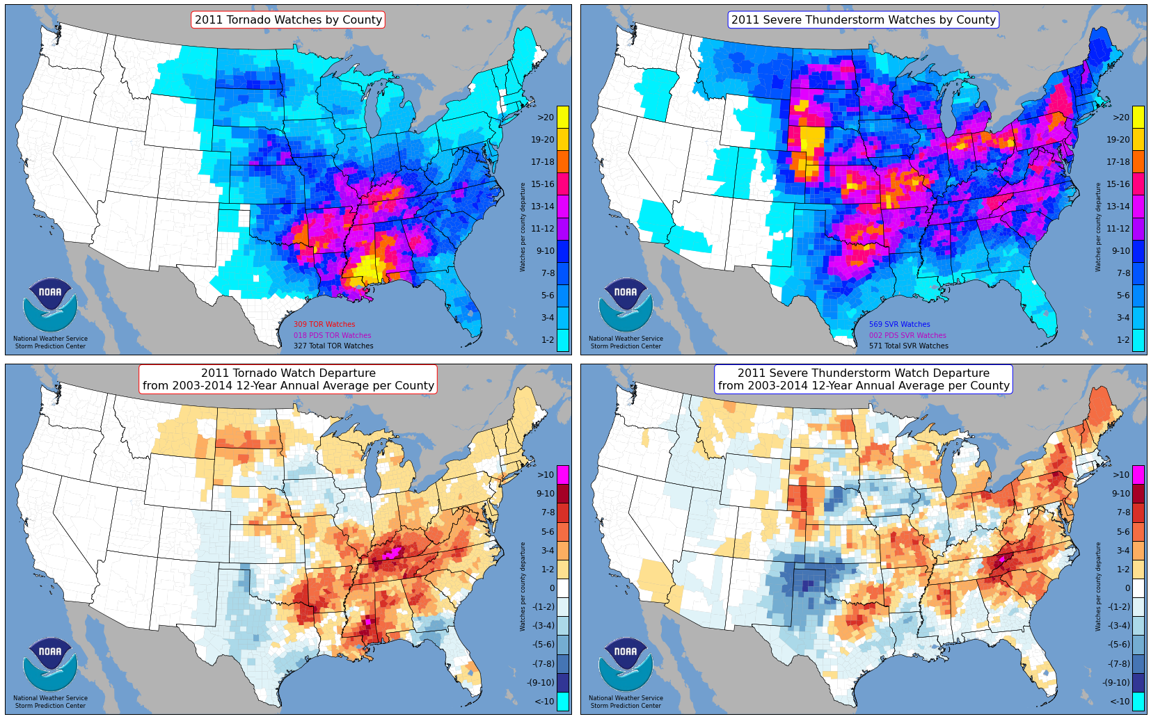
2011 Tornado and Severe Watch Count by County and Anomaly
(Click for full-resolution version.)
| | 2010 SPC Watch Frequency Maps |
|---|
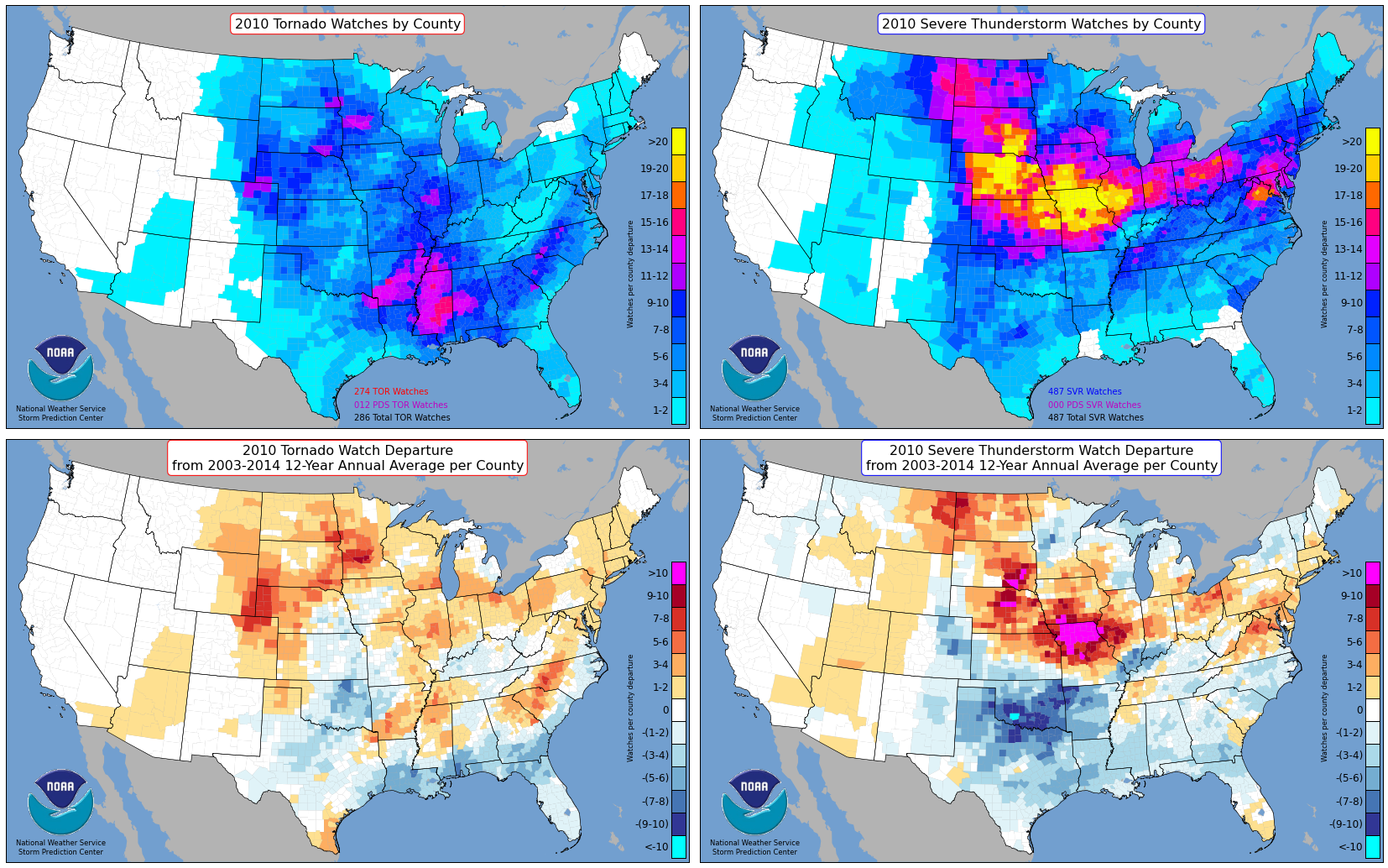
2010 Tornado and Severe Watch Count by County and Anomaly
(Click for full-resolution version.)
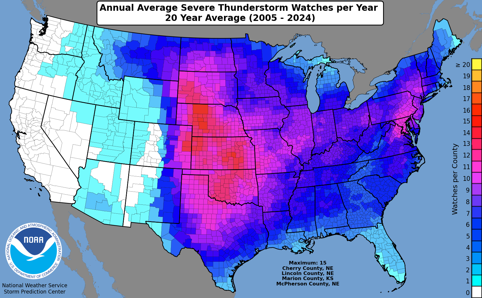
| | 20y SPC Watch Climatology |
|---|
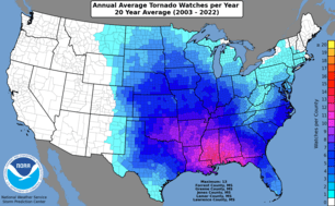
Average number of tornado watches per year (1993-2012).
(Click for full-resolution version.)
|
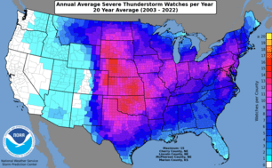
Average number of severe thunderstorm watches per year (1993-2012).
(Click for full-resolution version.)
|
| | SPC Tornado and Severe Weather Statistical Products on AWIPS |
|---|
Monthly Tornado Statistics are maintained in the AWIPS product STAMTS. Use this product to
find out how many tornadoes have occured so far this year and how
this year compares to past years.
Killer Tornado Statistics are listed in the AWIPS product STATIJ. Use this product for
information about killer tornadoes this year and in the past.
|
| Severe Weather Database Files (1950-2015) |
|---|
*** Annual updates occurred on March 9, 2016***
A few early tornado records have been added and/or corrected as part of the annual update to the tornado record. If you use the tornado csv files in any application, it is recommended that you download the updated "All_tornadoes.csv" file or "Actual_tornadoes.csv" file (see docs) from the link below and update your data accordingly.
*** Annual updates occurred on March 9, 2016 ***
*** Other changes to 1950-2015 U.S. tornado records ***
Estimated F-scale ratings were calculated for over 1800 tornadoes in the database previously rated with an F-scale entry of -9 (unknown). The scheme used to modify unknown F-scale to estimated F-scale is described in this document:
www.spc.noaa.gov/wcm/OneTor_F-scale-modifications.pdf
For all tornadoes modified in the database, a new information field was added to the database in 2016. The "fc" field (29th column of information in OneTor). "fc" is set to 1 for any tornado with a prior F-scale rating of -9. Thus, it is easy to filter previously unknown ratings, if desired. Please note! Tornadoes were likely underreported prior to 1953. Many tornado statistics are derived from 1953 (or later) to the present. Also, keep in mind that off-CONUS tornadoes are included in the latest version of the 1950-2016 tornado data. These events, while small in total count, include tornadoes in AK, HI, PR, and DC. It is best to filter results carefully when making queries on the tornado database.
The tables below provide the links to comma separated value (.csv) files for tornadoes, hail, and damaging wind, as compiled from NWS Storm Data. Tornado reports exist back to 1950 while hail and damaging wind events date from 1955. The full hail and wind datasets are very large. To facilitate quicker downloads these data have been parsed by decade (1950s through 1990s), and half-decade, or less (from 2000 to the present). Tornado data are provided in raw csv file format below. Actual tornado tracks only (not including individual state segments) are provided in the "Actual_tornadoes.csv" file. Again, please read the format specification for the tornado data.
Please read this document carefully as it describes the format of the .csv files (especially important for tornadoes!). Note 1: The NWS changed criteria for severe hail from 0.75 inch minimum to 1.00 inch minimum in 2010. For legacy purposes, 0.75 inch hail reports will continue to be included in the annual hail csv files. Download the files and sort accordingly if needed. Note 2: See last two pages of the database specification document about the addition of the estimated F-scale column "fc", added to tornado.csv data in 2015.
It should also be noted that these data are used by the NWS for verification purposes and may not accurately reflect all storm events. Monetary loss information is highly suspect and should be used with caution, if at all. This article provides a good overview about the shortcomings in the NWS severe weather data provided here.
|
All hail in one 5.5 mb zip file.
All wind in one 6.6 mb zip file.
Map of State FIPS Numbers here.
Text list of County FIPS Numbers here.
Better list of County FIPS Numbers (as xls file) here.
| | SPC Severe GIS Page |
|---|
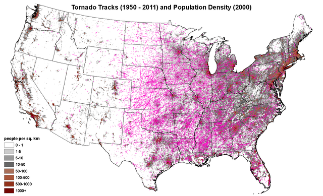
U.S. map depicting tornado tracks and population density.
(Click to go to SPC Severe GIS Page.)
|
Top/Forecast Products/Home
|
|


 @NWSSPC
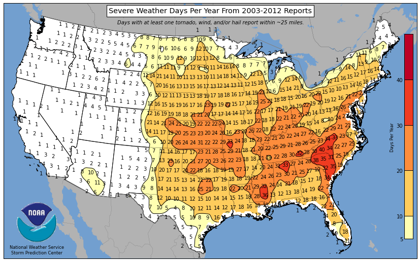


