| Radar:
Caribou ME |
46.03 N
- 67.80W
|
Period:
1980
-
2006
Range: 124 nm
|
Database Overview
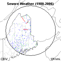 All severe weather
reports during the period are plotted. Blue dots represent damaging
wind, green dots represent large hail, and red dots represent tornadoes.
[Click to enlarge]
All severe weather
reports during the period are plotted. Blue dots represent damaging
wind, green dots represent large hail, and red dots represent tornadoes.
[Click to enlarge] |
| |
All
Rpts |
Sig
Rpts |
Avg
Days |
| Hail |
192
|
9 |
3 |
| Wind |
461
|
12 |
5 |
| Tornadoes |
14
|
1 |
0 |
| Total |
667
|
22 |
7 |
|
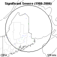 Significant
severe weather reports during the period are plotted. Only tornadoes
F2 or stronger, wind gusts of 65 knots or stronger, and hail of
2" diameter or larger are plotted. [Click to enlarge]
Significant
severe weather reports during the period are plotted. Only tornadoes
F2 or stronger, wind gusts of 65 knots or stronger, and hail of
2" diameter or larger are plotted. [Click to enlarge] |
| Category |
Rank*
|
Freq/mi2
|
| Any
Severe |
N/A
|
1:1,955
|
| Sig
Severe |
N/A
|
1:59,283
|
| Tornadoes |
N/A
|
1:93,160
|
| F2+
Torn |
N/A
|
1:1,304,235
|
* Compared to
141 national radar coverage areas studied. |
Annual
Report Information
|
|
Plot
of annual severe weather reports in the search area. The dashed
magenta line denotes a 5 year running average of all reports.
20 year report increase: 539%
10 year report increase: 1125%
5 year report increase: 819%
See
annual table below
|
Daily
Report Information
|
|
Plot
of daily severe weather reports in the search area. Lines denote
a 7 day running mean.
Maximum daily value:
0.6
on 01 Jul
Primary Season:
Jun 08
- Aug 23
See
monthly table below
|
Hourly
Report Information
|
|
Plot
of hourly severe weather reports in the search area. Values are
in percent of total, and have been rounded to the nearest hour (UTC).
Maximum hourly value:
18%
at 20 UTC
See
hourly table below
|
Climatological
Threat Potential
|
Threat
|
Avg Prob of Occurrence
|
Return Interval
|
Natl Rank
|
| Any
Tornado |
0.000%
|
N/A
|
N/A
|
| F2+
Tornado |
0.000%
|
N/A
|
N/A
|
|
This
table represents the average annual probability and return interval
of each event for any point within the search domain.
Read details of computational
method
|
Annual
Totals
|
Year
|
Hail
|
Wind
|
Tornado
|
Total
|
| |
Rpt
|
Days
|
Rpt
|
Days
|
Rpt
|
Days
|
Rpt
|
Days
|
|
1980
|
1
|
1
|
4
|
3
|
0
|
0
|
1
|
4
|
|
1981
|
1
|
1
|
1
|
1
|
0
|
0
|
1
|
2
|
|
1982
|
0
|
0
|
3
|
1
|
0
|
0
|
0
|
1
|
|
1983
|
10
|
4
|
22
|
5
|
0
|
0
|
10
|
7
|
|
1984
|
1
|
1
|
4
|
2
|
1
|
1
|
3
|
3
|
|
1985
|
4
|
3
|
4
|
3
|
0
|
0
|
4
|
5
|
|
1986
|
11
|
4
|
12
|
3
|
0
|
0
|
11
|
5
|
|
1987
|
3
|
3
|
1
|
1
|
0
|
0
|
3
|
4
|
|
1988
|
5
|
1
|
15
|
5
|
0
|
0
|
5
|
5
|
|
1989
|
1
|
1
|
15
|
7
|
1
|
1
|
3
|
7
|
|
1990
|
1
|
1
|
5
|
3
|
0
|
0
|
1
|
4
|
|
1991
|
10
|
5
|
15
|
6
|
1
|
1
|
12
|
8
|
|
1992
|
8
|
4
|
8
|
5
|
0
|
0
|
8
|
8
|
|
1993
|
4
|
2
|
4
|
4
|
1
|
1
|
6
|
5
|
|
1994
|
13
|
3
|
26
|
6
|
3
|
2
|
19
|
8
|
|
1995
|
2
|
2
|
11
|
4
|
0
|
0
|
2
|
4
|
|
1996
|
5
|
3
|
7
|
2
|
0
|
0
|
5
|
4
|
|
1997
|
1
|
1
|
9
|
2
|
3
|
3
|
7
|
5
|
|
1998
|
7
|
4
|
2
|
2
|
0
|
0
|
7
|
6
|
|
1999
|
10
|
3
|
32
|
5
|
0
|
0
|
10
|
5
|
|
2000
|
7
|
6
|
15
|
7
|
1
|
1
|
9
|
13
|
|
2001
|
4
|
2
|
11
|
7
|
1
|
1
|
6
|
9
|
|
2002
|
20
|
8
|
43
|
10
|
2
|
2
|
24
|
14
|
|
2003
|
13
|
6
|
37
|
8
|
0
|
0
|
13
|
10
|
|
2004
|
4
|
4
|
12
|
4
|
0
|
0
|
4
|
8
|
|
2005
|
6
|
5
|
36
|
10
|
0
|
0
|
6
|
12
|
|
2006
|
40
|
10
|
107
|
22
|
0
|
0
|
40
|
22
|
|
AVG
|
7
|
3
|
17
|
5
|
1
|
0
|
25
|
7
|
|
|
Violent
Tornadoes
|
|
Monthly
Averages
|
Month
|
Hail
|
Wind
|
Torn
|
Total
|
|
Jan
|
0
|
0
|
0
|
0
|
|
Feb
|
0
|
0
|
0
|
0
|
|
Mar
|
0
|
0
|
0
|
0
|
|
Apr
|
0
|
0
|
0
|
0
|
|
May
|
0
|
1
|
0
|
1
|
|
Jun
|
2
|
5
|
0
|
8
|
|
Jul
|
4
|
7
|
0
|
11
|
|
Aug
|
1
|
4
|
0
|
5
|
|
Sep
|
0
|
1
|
0
|
1
|
|
Oct
|
0
|
0
|
0
|
0
|
|
Nov
|
0
|
0
|
0
|
0
|
|
Dec
|
0
|
0
|
0
|
0
|
|
Hourly
Averages
|
UTC
|
Hail
|
Wind
|
Torn
|
Total
|
|
00
|
15
|
51
|
2
|
68
|
|
01
|
6
|
22
|
1
|
29
|
|
02
|
1
|
8
|
0
|
9
|
|
03
|
6
|
10
|
0
|
16
|
|
04
|
3
|
4
|
0
|
7
|
|
05
|
1
|
3
|
0
|
4
|
|
06
|
0
|
3
|
0
|
3
|
|
07
|
0
|
3
|
0
|
3
|
|
08
|
0
|
2
|
0
|
2
|
|
09
|
0
|
15
|
0
|
15
|
|
10
|
0
|
5
|
0
|
5
|
|
11
|
0
|
0
|
0
|
0
|
|
12
|
0
|
0
|
0
|
0
|
|
13
|
0
|
0
|
0
|
0
|
|
14
|
2
|
1
|
0
|
3
|
|
15
|
2
|
3
|
0
|
5
|
|
16
|
4
|
8
|
3
|
15
|
|
17
|
9
|
10
|
1
|
20
|
|
18
|
22
|
31
|
1
|
54
|
|
19
|
35
|
52
|
1
|
88
|
|
20
|
45
|
74
|
2
|
121
|
|
21
|
17
|
53
|
2
|
72
|
|
22
|
14
|
59
|
0
|
73
|
|
23
|
10
|
44
|
1
|
55
|
|
Click Here for tabular data (F2+ tornadoes).
|