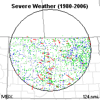
Radar:       Or click here for map
Radar: Minot AFB ND
48.38 N - 100.85W
Period: 1980 - 2006      Range: 124 nm

Database Overview
All reports in the domain All severe weather reports during the period are plotted. Blue dots represent damaging wind, green dots represent large hail, and red dots represent tornadoes. [Click to enlarge]
  All Rpts Sig Rpts Avg Days
Hail
2459
215 22
Wind
1243
225 14
Tornadoes
454
24 8
Total
4156
464 29
Significant severe reports Significant severe weather reports during the period are plotted. Only tornadoes F2 or stronger, wind gusts of 65 knots or stronger, and hail of 2" diameter or larger are plotted. [Click to enlarge]
Category
Rank*
Freq/mi2
Any Severe
N/A
1:314
Sig Severe
66
1:2,811
Tornadoes
N/A
1:2,873
F2+ Torn
N/A
1:54,343
* Compared to 141 national radar coverage areas studied.

Annual Report Information
Annual severe weather reports
Plot of annual severe weather reports in the search area. The dashed magenta line denotes a 5 year running average of all reports.

20 year report increase: 124%
10 year report increase: 73%
5 year report increase: -20%

See annual table below

Daily Report Information
Annual severe weather reports
Plot of daily severe weather reports in the search area. Lines denote a 7 day running mean.

Maximum daily value:
2.3 on 18 Jul

Primary Season:
May 16 - Sep 06

See monthly table below

Hourly Report Information
Annual severe weather reports
Plot of hourly severe weather reports in the search area. Values are in percent of total, and have been rounded to the nearest hour (UTC).

Maximum hourly value:
12% at 00 UTC

See hourly table below

Climatological Threat Potential
Threat
Avg Prob of Occurrence
Return Interval
Natl Rank
Any Tornado
0.003%
32706 yrs
N/A
F2+ Tornado
0.002%
48547 yrs
N/A
This table represents the average annual probability and return interval of each event for any point within the search domain.

Read details of computational method

Annual Totals
Year
Hail
Wind
Tornado
Total
 
Rpt
Days
Rpt
Days
Rpt
Days
Rpt
Days
1980
57
23
45
20
20
7
97
31
1981
47
18
29
15
11
6
69
26
1982
60
17
38
16
11
10
82
27
1983
49
16
69
21
15
10
79
31
1984
18
9
25
13
11
9
40
24
1985
24
10
11
4
21
7
66
16
1986
63
21
34
20
16
9
95
31
1987
18
9
15
7
10
4
38
14
1988
29
15
23
14
17
7
63
22
1989
40
16
42
15
9
7
58
24
1990
52
15
40
15
19
7
90
22
1991
71
21
46
19
6
3
83
29
1992
37
11
6
5
5
4
47
16
1993
24
12
15
11
31
11
86
23
1994
78
29
25
15
16
10
110
37
1995
42
17
52
11
8
6
58
20
1996
89
22
38
14
19
11
127
28
1997
89
27
54
21
22
10
133
34
1998
106
25
14
7
17
9
140
28
1999
155
29
71
19
41
10
237
30
2000
181
30
69
13
22
9
225
34
2001
176
29
112
19
30
12
236
34
2002
253
34
83
18
11
8
275
40
2003
147
29
66
10
18
11
183
32
2004
166
41
43
8
20
7
206
42
2005
197
40
122
21
22
9
241
44
2006
191
35
56
19
6
3
203
40
AVG
91
22
46
14
17
8
154
29


Violent Tornadoes
Date
F
Deaths
Injuries
1999 06-Jun 2020 UTC
F4
0
0
2002 11-Aug 2100 UTC
F4
0
0

Monthly Averages
Month
Hail
Wind
Torn
Total
Jan
0
0
0
0
Feb
0
0
0
0
Mar
0
0
0
0
Apr
1
0
0
1
May
8
2
1
12
Jun
24
12
7
43
Jul
29
18
6
53
Aug
25
12
2
39
Sep
4
1
0
5
Oct
0
0
0
0
Nov
0
0
0
0
Dec
0
0
0
0

Hourly Averages
UTC
Hail
Wind
Torn
Total
00
322
97
82
501
01
309
114
45
468
02
278
126
39
443
03
167
108
27
302
04
97
90
19
206
05
96
101
11
208
06
49
93
7
149
07
38
77
2
117
08
55
48
1
104
09
38
35
0
73
10
44
53
5
102
11
40
39
2
81
12
27
13
0
40
13
32
8
0
40
14
23
8
0
31
15
31
9
1
41
16
21
5
0
26
17
18
19
1
38
18
21
10
8
39
19
47
13
33
93
20
84
15
47
146
21
114
47
26
187
22
181
50
39
270
23
327
65
59
451

Click Here for tabular data (F2+ tornadoes).
Page Updated: Saturday 10-27-2007
If you have comments regarding this information, contact John Hart of the Storm Prediction Center.
Go to SPC web page Go to NWS web site Go to NOAA web site