|
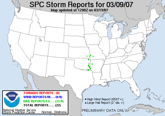
20070309's Storm Reports
|
< 070308 Reports
070310 Reports >
|
|
| Note: All data are considered preliminary |
| Tornado Reports (in CSV format) |
|---|
| No reports received |
| Hail Reports (in CSV format) |
|---|
Time | Size | Location | County | State | Lat | Lon | Comments |
| 2250 | 75 | 5 N NEODESHA | WILSON | KS | 3750 | 9568 | (ICT) |
| 2329 | 75 | MOUNDVILLE | VERNON | MO | 3777 | 9445 | (SGF) |
| 2345 | 100 | WILBURTON | LATIMER | OK | 3492 | 9531 | (TSA) |
| 2345 | 75 | 2 N LEQUIRE | HASKELL | OK | 3513 | 9511 | (TSA) |
| 2350 | 88 | VIAN | SEQUOYAH | OK | 3550 | 9497 | (TSA) |
| 0000 | 100 | BRONAUGH | VERNON | MO | 3769 | 9447 | (SGF) |
| 0005 | 100 | 5 NW VINITA | CRAIG | OK | 3669 | 9522 | HAILED FOR ABOUT 20 MIN...WITH A FEW STONES LARGER THAN 1 INCH. (TSA) |
| 0037 | 88 | 1 S VINITA | CRAIG | OK | 3662 | 9515 | (TSA) |
| 0045 | 100 | 1 W TALIHINA | LATIMER | OK | 3475 | 9507 | (TSA) |
| 0049 | 88 | WHITESBORO | LE FLORE | OK | 3469 | 9489 | (TSA) |
| 0109 | 100 | 1 N LANGLEY | MAYES | OK | 3648 | 9505 | AT HWY 82 AND 28 NEAR LANGLEY. (TSA) |
| 0110 | 100 | BRANCH | FRANKLIN | AR | 3531 | 9395 | (TSA) |
| 0120 | 75 | 2 S POWDERLY | LAMAR | TX | 3378 | 9553 | SPOTTER REPORT FROM ROAD 2648 AND US 261 SOUTH OF POWDERLY. (FWD) |
| 0120 | 100 | FRONTENAC | CRAWFORD | KS | 3746 | 9469 | (SGF) |
| 0135 | 88 | 1 N PITTSBURG | CRAWFORD | KS | 3743 | 9470 | (SGF) |
| 0143 | 88 | DETROIT | RED RIVER | TX | 3366 | 9527 | (SHV) |
| 0208 | 100 | 6 ESE DETROIT | RED RIVER | TX | 3363 | 9517 | US 82 NEAR LITTLE CHICAGO. (SHV) |
| 0215 | 100 | HOCHATOWN | MCCURTAIN | OK | 3420 | 9467 | BROKEN BOW LAKE. (SHV) |
| 0225 | 100 | BATTIEST | MCCURTAIN | OK | 3440 | 9493 | (SHV) |
| 0250 | 88 | HOCHATOWN | MCCURTAIN | OK | 3420 | 9467 | SOUTHWEST SIDE OF BROKEN BOW LAKE. (SHV) |
| 0305 | 88 | 3 ENE BROKEN BOW | MCCURTAIN | OK | 3404 | 9469 | US 70. (SHV) |
| 0351 | 75 | 1 W WALNUT GROVE | GREENE | MO | 3741 | 9357 | (SGF) |
| Wind Reports (in CSV format) |
|---|
| No reports received |
| Full report
in comma-separated values (CSV) format |
| Fields marked UNK are unknown |
| All Times UTC |
| Wind Gusts in MPH |
| Hail Sizes in 1/100 of an Inch (75 = 0.75") |
| List of Weather Forecast Office 3-letter IDs appear in the report comments section |
|
|
|
Top/Storm Reports/Home
|
|


 @NWSSPC