|
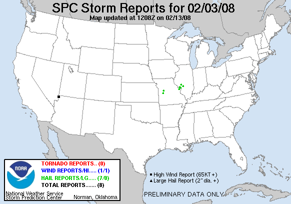
20080203's Storm Reports
|
< 080202 Reports
080204 Reports >
|
|
| Note: All data are considered preliminary |
| Tornado Reports (in CSV format) |
|---|
| No reports received |
| Hail Reports (in CSV format) |
|---|
Time | Size | Location | County | State | Lat | Lon | Comments |
| 1641 | 75 | 5 ESE CLINTON | HENRY | MO | 3835 | 9369 | (EAX) |
| 1755 | 100 | WHITEMAN AFB | JOHNSON | MO | 3873 | 9355 | ONE INCH HAIL REPORTED AT WHITEMAN AIR FORCE BASE. (EAX) |
| 2153 | 75 | ST. CHARLES | ST. CHARLES | MO | 3879 | 9052 | PEA TO DIME SIZE, LASTED LESS THAN 3 MINUTES (LSX) |
| 2200 | 75 | GODFREY | MADISON | IL | 3897 | 9019 | UP TO 3/4 INCH HAIL, COVERING THE GROUND. (LSX) |
| 2208 | 100 | 15 NW ALTON | JERSEY | IL | 3906 | 9035 | DIME TO QUARTER SIZE HAIL. BRIEF. (LSX) |
| 2216 | 75 | PALMYRA | MACOUPIN | IL | 3943 | 9000 | DIME TO PENNY SIZE, LASTED LESS THAN A MINUTE. (LSX) |
| 2225 | 100 | LITCHFIELD | MONTGOMERY | IL | 3918 | 8966 | NICKEL TO QUARTER SIZE COVERING THE GROUND. (LSX) |
| Wind Reports (in CSV format) |
|---|
Time | Speed | Location | County | State | Lat | Lon | Comments |
| 0030 | 75 | MESQUITE | CLARK | NV | 3679 | 11407 | (VEF) |
| Full report
in comma-separated values (CSV) format |
| Fields marked UNK are unknown |
| All Times UTC |
| Wind Gusts in MPH |
| Hail Sizes in 1/100 of an Inch (75 = 0.75") |
| List of Weather Forecast Office 3-letter IDs appear in the report comments section |
|
|
|
Top/Storm Reports/Home
|
|


 @NWSSPC